Significant Northeast Snowstorm Likely Tomorrow
The biggest snowstorm for parts of the nor’easter-prone New England and Mid-Atlantic in several years still appears set to deliver a wide swath of 1-2 feet of snow and strong wind to millions along and northwest of parts of the I-95 corridor.
If you’re curious as to how the pieces behind this snowstorm are making their way to the eastern seaboard, check out Meghan’s blog from yesterday. This blog will concern more with the specifics of forecasting where the heaviest snow will fall.
This write up will start Wednesday afternoon. Cold air damming will see surface low redevelopment east of the Appalachians, and an immature nor’easter will deepen while moving almost due north near the Chesapeake.
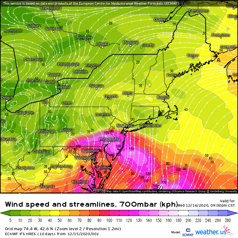
While the midlevel support isn’t all that exciting, dynamics directly relevant to snowfall at this time will be impressive. One important one is midlevel frontogenesis, a function of change in wind direction and speed along a streamline that can inject hefty lift directly into the parts of the column most favorable for snow growth. Generally one can see the fiercest zones of 700mb frontogenesis, which correspond well with the type of snow bands that drop 1-3″/hr, just by looking at 700mb flow fields. The point of all that is to say that, with a roaring 700mb jet slowing dramatically over parts of MD and PA, midlevel lift will be absolutely thumping as the surface low begins pushing north into an expansive surface high.
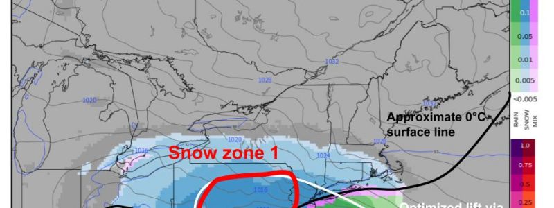
This means that the storm will probably start with the bang of an impressive snow band, immediately to the north and west of the surface low and associated freezing line. As the surface low slows towards nightfall near Delaware, an impressive curved band of snow will correspondingly slow over PA. This will make ‘zone one’ of snow forecasting, with significant accumulations possible amidst persistent overlapping of moisture, lift, and cold air as the surface low slowly pulls away over the next 12 hours.
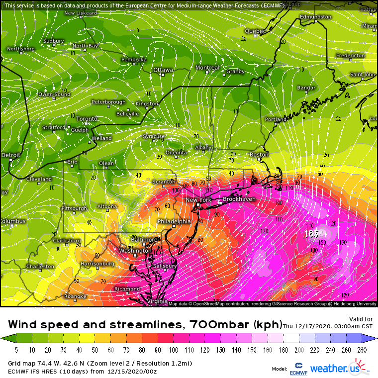
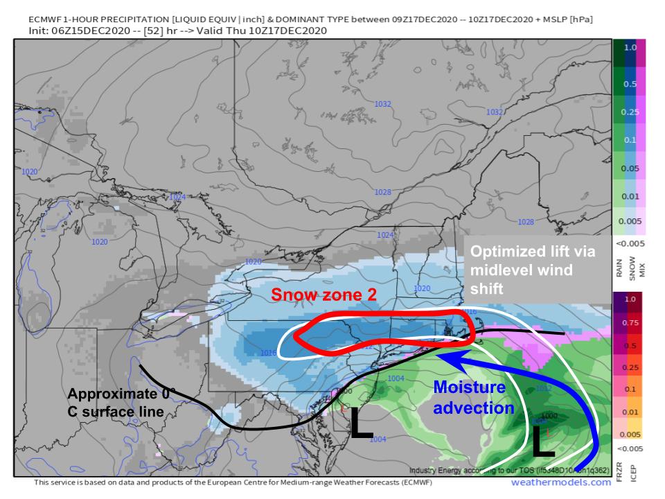
Overnight tomorrow, the midlevel energy will begin stretching out and weakening as the surface low occludes. This combination will allow a secondary depression to develop SE of Long Island, and the result will be a somewhat unusual band of forcing that’s nearly horizontally oriented. This is fairly reminiscent of 3/22/2018 and 1/24/2016, for some recent examples, but most northeast snow bands are oriented N/S more than E/W.
We can see this 700mb wind shift very clearly across parts of NY, CT, RI, and MA on a flow map at that level, and it will correspond with another zone quite favorable for significant snow accumulations in powerful banding. This is zone 2 of our forecast.
This zone will also feature persistent banding with efficient snowfall production at the hands of an overlap between moisture, strong lift, and cold air.
The reason I’ve broken our storm into two distinctive ‘snow zones’ is because each will have distinctive forecast issues.
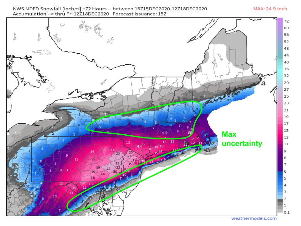
Zone 1 will feature the most snow out of this storm, almost certainly, as the pivoting bands see significantly persistent snowfall. Someone in this region will probably see >24″ out of this storm. But forecasting snow zone 1 will involve, of course, conditionality on the surface low’s placement. A further NW track will bump the significant band NW, and vice versa, with the highest snowfall accumulations reacting in tandem. A more significant forecast challenge here, though, will be in placing the rain/snow transition zone. The proximity of significant banding to the surface low in zone 1 will mean the SE cutoff of totals will be very steep, and will likely occur near population centers like Philadelphia and Baltimore. Right now, this gradient looks likely north of a line from Washington, DC to Monmouth County, NJ, but small track adjustments here will mean potential for big impacts or big disappointments.
Zone 2 will look on snow maps like an extension of zone 1 to the east and northeast, with a long, increasingly narrow swath of 12+” of snow stretching from NE PA to somewhere in S. New England. Amounts here will likely be lower than zone 1, with less persistence of lift and less intense snowfall ratios expected, but somebody will probably see 18″. Because of the nature of this snow zone, forecasting will be tricky, though. Steep moisture cutoffs to the north, due to the horizontal orientation of banding, will likely lead to a sharp, nearly vertical, snowfall accumulation gradient in New England, This gradient looks most likely from near or south of Albany through central or northern MA, although it could easily end up in CT or northern New England depending on relatively minor track adjustments. Meanwhile, another gradient will develop to the south of the band, where precipitation type issues and dry slotting will cause totals to drop off considerably. This will probably remain immediately near the coast in parts of LI, RI, and SE MA, although some models like the NAM want to bring it into south-central New England. That’s right- some models show the southern snow gradient where others show the northern snowfall gradient. The biggest bust potential with this zone will therefore be in parts of southern New England adjacent to the coast, and inland central New England.
Combining the uncertainty in our two snow zones layering them over a map of NWS snowfall forecasts gives us the map I will leave you with today.
Stay tuned to our twitter and blog for more as the storm progresses!
