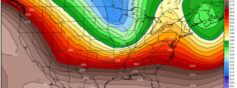
Quick-Hitting System to Impact the US Before the Big Chill
The long-duration nor’easter that dropped a widespread 1, 2, even 3 feet of snow is finally on it’s way out. But there is no rest for the weather-weary as the next system is already cranking up on the west coast this morning.
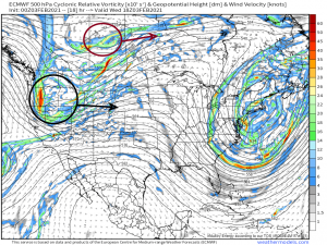
Two areas of vorticity, one over western Canada and one over the western US, will perpetuate eastward to form our next system. They will not phase, though, and the southern low will eventually become the dominant one as it lifts over the Great Lakes into Canada.
This system won’t be a huge problem for the northeast as they dig out from the prolonged snowfall of the past few days, however, and here’s why:
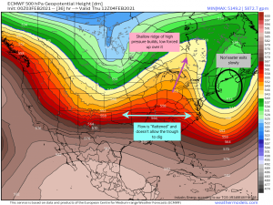
The trough associated with the nor’easter is taking its sweet time moving out. The longer it hangs around, the flatter the flow between the two troughs will be. The absence of a strong ridge between the two troughs means that the second system can’t “dig” south. It will dig just a little as it crosses the Rockies in response to a building ridge behind it and the shallow ridge ahead. The ridge ahead then deflates, forcing a more zonal flow and flattening the trough, keeping the low locked up north of the jet stream.
This system won’t be hanging around, either. No prolonged periods of snowfall are expected as it will cross the country and be gone by early Saturday.
So that’s the set up, but what are the implications?
Well, for the northern plains, this means snow and cold, windy conditions. The northwest flow will be roaring behind this low and bringing in some frigid air with it. Blizzard conditions are possible today and tomorrow as this event gets going. Snow totals will be fairly low here as the real moisture gets added later on.
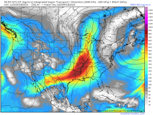
This system will have plenty of access to moisture as it perpetuates eastward. The majority of the heavy snow from this system will be seen over the Great Lakes as the southerly flow from low draws from the Gulf of Mexico. The northernmost parts of the Great Lakes will see the most snow while the southern parts will struggle with mixing or just plain cold rain due to the position of the low and warm air advection aloft around it.
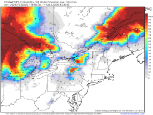
By the time this reaches the northeast, not only will it be moving quickly, but it will be running out of moisture. As it lifts north, it moves further away from it’s source (the Gulf) and will produce less in the way of precipitation, so heavy snowfall is not expected. We will also encounter mixing issues over the southern parts of the northeast, again, due to the position of the low and the warm air being advected in.
So, taking into account all I’ve mentioned above, there is very little chance for any plowable (3+ inches) snow across the northeast. The exception would be the parts prone to lake effect snow, and that will come on the back side of the system. Hefty northwest winds could produce decent snowfall downwind of the lakes. Otherwise, residents of this area of the country get a break from shoveling out their properties for a bit.
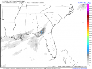
But what about the south? Typically, this would be an excellent set up for a severe threat. Fortunately (or unfortunately, should you be one that enjoys severe weather), a cold, stable air mass is in place over the south right now. For reference: Florida dipped into the 30s last night and will likely do so again tonight. So, yeah, it’s cold; the mountains in north Georgia saw snow yesterday. This system is moving quickly so the south won’t spend enough time in the favorable southerly flow for decent destabilization to happen. We’re mainly looking at plain old rain.
There is one minor exception:
Southern Georgia and Northern Florida could see enough destabilization to produce a few thunderstorms. Currently, it doesn’t look like enough to allow for severe storms, only general thunderstorms and even that might be a stretch. But, the atmosphere being what it is and constantly changing, we will keep an eye on this area since, as we’ve seen numerous times this winter, even a marginal threat can produce serious severe weather.
Beyond it’s immediate effects, this system will serve to usher in the coldest air we’ve seen so far this season.
As the system exits, a cross-polar flow allows it to pull in Arctic air behind it. Yes, I said Arctic. Northern parts of the country will most definitely be dipping below zero at some point as long as this air mass is in place. It is somewhat unclear how far south the cold air will plunge, however, as more recent guidance suggests a less southerly solution than was previously modeled at the beginning of the week. We’ll look more closely at this toward the end of the week.
Now go enjoy your last few days of warm-ish weather (depending on where you are) before the real cold makes an appearance. Have a wonderful day!
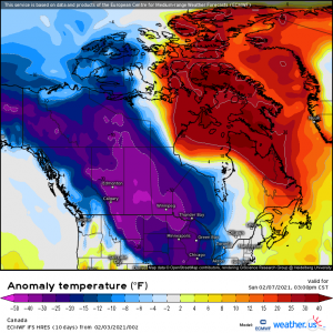


I am curious on your thoughts on how far west this artic air could push? gfs18z and the the last few runs have it trending more and more west, as far west as the pacific north west coast. waiting on 00z right now. wondering what your thoughts are and how much the high pressure of the coast of the western states might play in the placement of this cold air.
thank you,
Austin Gonzales
Hi, Austin! So, I took a quick look this morning and it seems to me that the high building off the west coast will keep the really cold air confined just barely east of the Pacific Northwest. It seems to almost make it out there but then the high builds in and pushes it east. Though the NW looks chilly, it doesn’t get the brunt of the Arctic blast. Of course that could change since guidance on this air mass has been a little iffy, but for now at least, it doesn’t look to directly impact the NW.