Powerful Winter Storm To Bring Blizzard Conditions to Parts of Midwest
It isn’t easy for one storm system to create significant, impactful weather on both sides of the rocky mountains, but a trough currently deepening into the north-central US is managing it. After slamming the Pacific Northwest with heavy rain and snow and then bringing a significant windstorm to the north-central Plains, the system will allow an impactful winter storm to develop across parts of the midwest today.
A reconfiguration of the low level pressure field at the hands of the digging longwave is happening across the central US as I write this. It will prove very important over the next 24 hours of sensible weather.
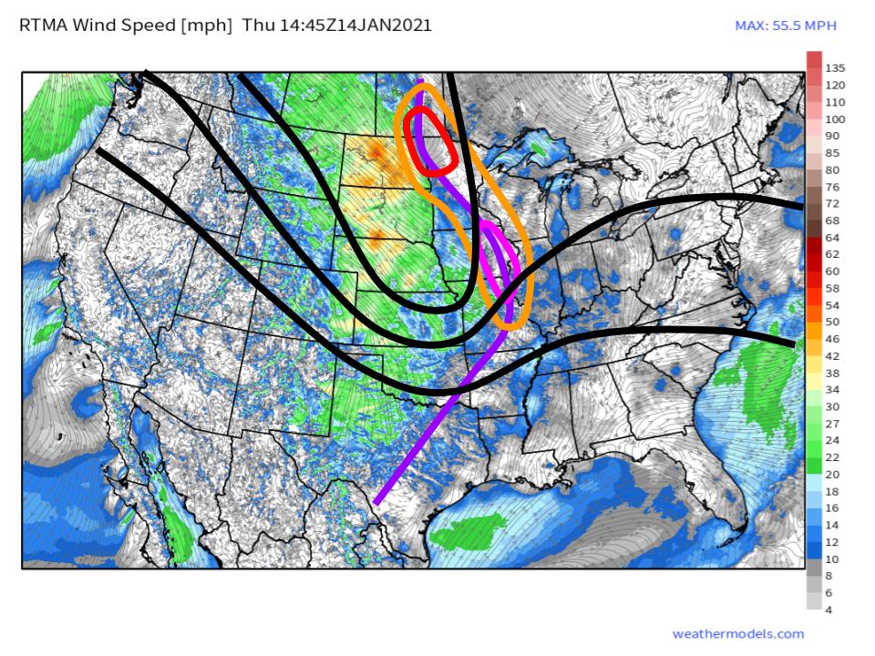
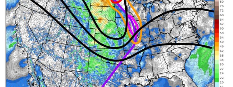
Over the north-central US and adjacent Canada, a broad, mature cyclone (red) rests close to the center of a 500mb trough (black) axis. As the trough digs into the central Plains, an exit region with tremendous directional divergence is allowing for a secondary pressure minimum to develop over the midwest, around Iowa (pink). Both zones of low pressure extend along a significant wind shift (purple), which is serving as the focal axis for moderately intense rain and snow showers this morning.
As the trough continues to deepen today, the very favorable dynamics will allow the secondary (pink) cyclone to intensify quite quickly. The primary (red) cyclone, meanwhile, is largely without midlevel support, having retrograded towards the center of the attendant trough. As a result, it will increasingly ‘open up’ to the south. The result will be a pressure field increasingly centered over the secondary cyclone, which will become dominant later today. As this process occurs, an elongated zone of low pressure (orange) will slowly consolidate south, as the primary cyclone is ‘absorbed’ into the secondary one. The steady precipitation along the surface boundary will increase in intensity as the secondary cyclone strengthens, eventually evolving into banding with impressive snowfall rates as the system consolidates.
This will set the stage for a powerful blizzard.
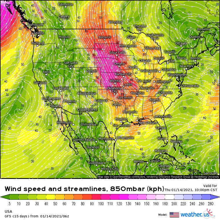
Behind the increasingly contorted surface boundary, which exists along a trough of low surface pressure, a powerful low level dome of high pressure over the Rockies has allowed an impressive pressure gradient to develop. This was responsible, in part, for a strong low level jet that developed absolutely roaring winds over the northern Plains last night.
As the low-level cyclone develops southward into the midwest today, the LLJ will shift southward, where it will serve to advect air from the north into parts of the midwest.
Notice I say “air from the north” instead of something like “frigid continental air”. Typically, this kind of northerly advection regime would see wind chills weeeeell into the negatives for the region, but this is an exceptional event.
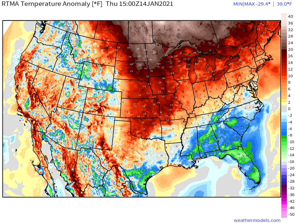
The exceptional aspect of this blizzard? How warm antecedent temperatures are to the north!
Current anomalies well in excess of +20°F at the entrance region of this advection regime are the norm, where several record high daily temperatures have been met over the last couple days. This will help prevent the snowstorm from being a truly blockbuster, absolutely frigid midwest blizzard. It will also mean that precipitation will start off as a mix of rain and snow, even to the northwest of the developing cyclone.
Eventually, by late this afternoon, dynamic cooling at the hands of increasingly intense banding and strengthening northerly flow will ensure all precipitation to the cyclone’s northwest turns to snow. This snow will often be heavy tonight, and will coincide with ripping winds. Blizzard conditions are likely, especially in a swath from far NW MO through much of W IA, SW MN, far NE NE (haha), and E SD.
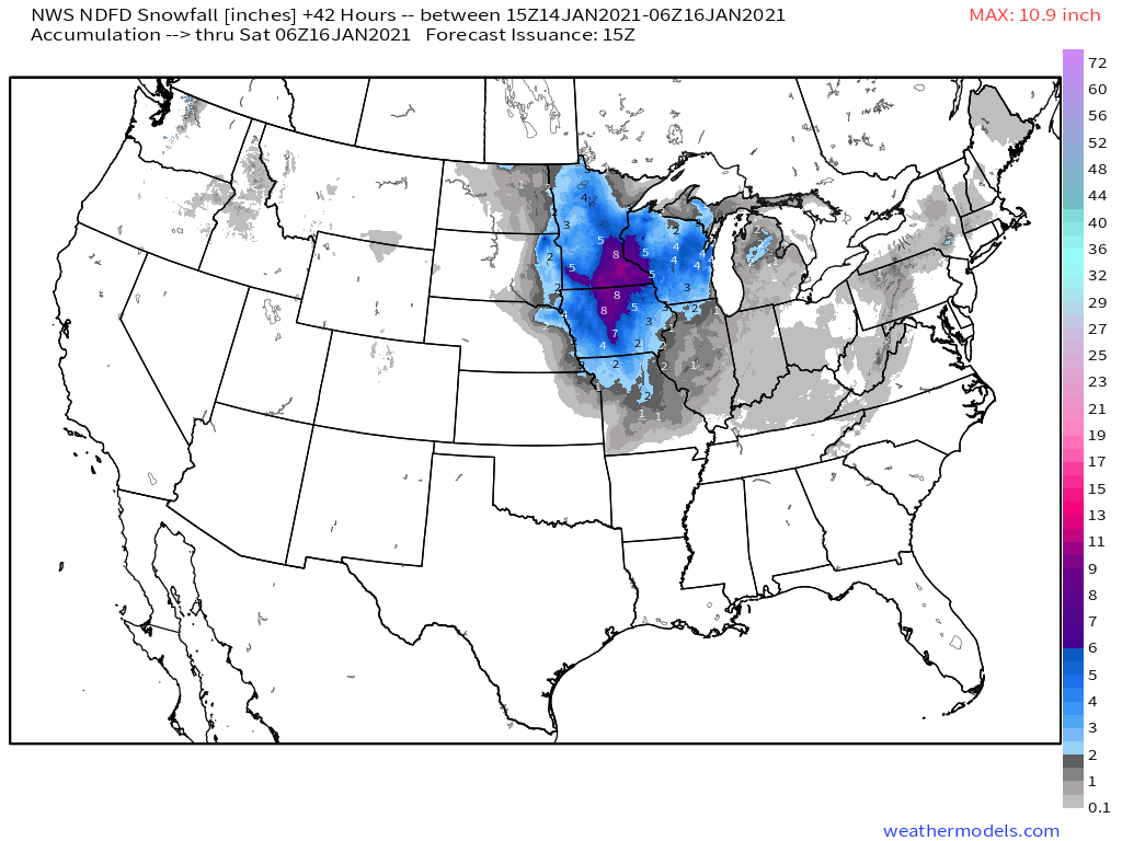
The snow will stick around for a while, too. The 500mb trough will amplify to such an extent that it will close off late tonight into an expansive midlevel low, a process that will allow the low level cyclone to basically sit still for ~12 hours, perhaps moving in a small loop over IA while occluding. By tomorrow afternoon, a plowable amount of snow will have fallen- model consensus calls for 6-12″ in a swath from Minnesota to Iowa. Howling winds will create snow drifts much larger, and blowing snow will create conditions outsized for the relatively moderate snow accumulations.
As occlusion wraps up tomorrow and the cyclone becomes increasingly mature and stacked vertically, snowfall rates will decrease and spread south and west in increasingly diffuse banding. Near-blizzard conditions will likely occur with this band across a wide swath of the central US, although relatively minimal duration and moderate intensity will keep accumulations low. By late tomorrow night, the surface low will essentially dissipate near Kentucky.
