Nor’easter Continues With Heavy Snow, Strong Wind, Significant Power Outage Threat
Well, here we are. A significant southern stream cyclone has completely phased with a large northern stream trough, and a significant, negatively tilted midlevel shortwave axis now lies over the northeastern US. Incredible divergence ahead of the system, a combination of rapidly spreading isoheights and a jet streak stretching from Maine into SE Canada, is allowing for the type of rapid deepening of a surface low that’s familiar to New England winters. In other words, a classic nor’easter.
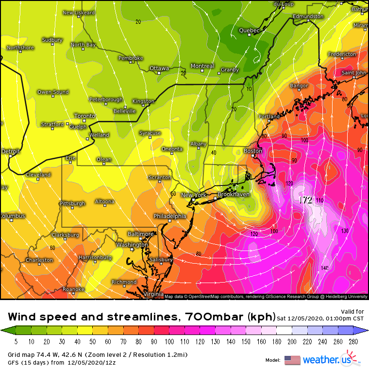
A band of powerful midlevel lift has developed over a swath of the Northeast, like we expected. It formed along a strong zone of shifting winds, where the roaring southerly jet smashed into northerly flow. At the surface, this would be called a warm front, and when it happens at 700mb, it produces many of the same impacts: broad, sometimes very significant lift conducive to heavy stratiform precipitation. In this map, the wind shift can be seen where the colors bunch really close together, as this is where wind dramatically slows.
The main benefit of looking at 700mb is that it shows where this lift is strongest in places where snow can develop efficiently, a place known as the “dendrite growth zone”.
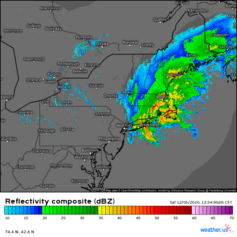
Anyway, a band of very heavy precipitation has developed along this wind shift.
Some of the higher reflectivity with this band is simply “bright banding”, in which high-reflectivity melting snow reflects a lot of energy back at the RADAR, giving the appearance of unreasonably heavy precipitation. But there is also a band of genuinely very strong precipitation, stretching from Long Island through central CT and MA, and into E NH and ME. Where it’s cold enough, snow here is falling quite hard, likely approaching 2″/hr in central MA into parts of SE ME. As the surface low continues to move northeast, this zone of very heavy precipitation will too, eventually impacting Maine, where it will sit through the night and drop the heaviest snow of the storm.
Most of the nuance with this forecast involved the aggressively marginal thermal profile, which allowed much of the precipitation to fall as rain across portions of Connecticut and Massachusetts, and made the snowfall forecast significantly trickier elsewhere. In fact, temperatures in most places are still at least a bit above freezing. If antecedent temperatures were more seasonal, this would probably be the most impactful New England snowstorm since 2015. But alas.
Regardless of how much I wish it were colder, it isn’t, and temperatures will be the backbone of this discussion.
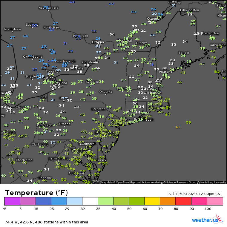
This image of current (as of 1:00pm) surface temperatures is really interesting for a couple reasons.
First of all, almost universally, temperatures are above freezing across New England. The fact that it’s snowing at all is because the incredible dynamics of the system serve to create its own cold air, if you will. This mostly happens via melting snowflakes, which remove heat from the air- kind of like how condensing air creates heat in thunderstorms, but the opposite. Latent heat really is the gift that always gives! Anyway, these processes are depressing temperatures where the heaviest precipitation is falling, which is why a band of relative cold has developed from New Haven, CT north to Bangor, ME. Notice that it isn’t actually below freezing, typically. However, with heavy snow falling, the 32° precipitation should be able to bring the surface down to 32°, and allow for accumulations, reasonably quickly. These feedback loops mean that, where banding is strongest, snow will be most likely to fall, which will mean snow is most likely to accumulate, too.
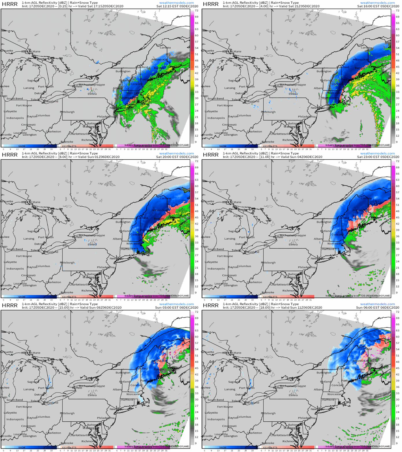
I’ve just said a lot of things about what’s happening now, and hinted a bit about what will happen next. I think a good way to crystallize all of it is to show you what the HRRR thinks will happen through tonight.
Today’s big precipitation story will be the band of heavy snow slowly pivoting through New England, described and then depicted above. But another significant weather maker will be the wind!
Bombogenesis to this degree definitionally comes with rapidly intensifying pressure gradients, which means very strong low level flow! This flow will be roaring most notably close to the low and near low-friction water, as usual, where it will deliver 50-60mph NW wind gusts to much of far E MA this afternoon. But a much more potentially significant threat will be slightly weaker gusts, likely 40-50mph, which blow where the snow is falling.
Water is heavy! The only reason trees don’t all collapse whenever it rains is because rain drips off of things. This is why freezing rain causes so many power outages; when the rain is frozen, it sticks, and forces structures to collapse under the weight of all that stuck water. Some snow, typically wet, heavy snow in marginal thermodynamic profiles, can stick similarly well to ice, and can then also cause huge weight loads on trees and other structures. This looks likely to happen today, especially where 10+” of very heavy, wet snow accumulate within the track of the significant band I’ve been talking about.
Where strong, gusty winds overlap with the heaviest snow, significant and potentially widespread power outages may occur. This kind of snow can snap pine branches!
Clearly, this storm looks intent on bringing numerous significant impacts to the northeast today, with snowfall exceeding a foot in places, strong winds, and potentially significant power outages. We will, of course, keep you posted on twitter!


