Multi-Day Severe Threat Takes Aim at the South
Another system, eerily similar to the one we saw not two days ago, is making it’s way across the country this morning. It brings with it multiple hazards: ice, snow, and a multi-day severe threat. If you’re interested in the winter weather portion of this system, please hop on over to Jacob’s blog from yesterday, where he outlined the forecast in detail. I’ll be focusing on the severe threat embedded in the southerly portion of this system.
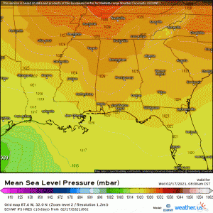
As a longwave trough swings eastward today, embedded shortwaves will incite the development of a surface low over the western Gulf. This low will then perpetuate eastward along the coast and up into the southeast. As it moves, the associated warm front will lift over parts of the southeast, beginning with the central Gulf coast this evening, with a speedy southerly low level jet advecting in warmth and moisture.
As mentioned, this will translate to a multi-day severe threat.
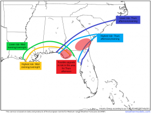
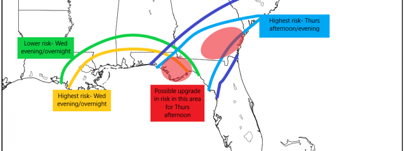
The timing and associated threats look a bit like this. Since the threats are a bit different for each day, we’ll address them separately.
Wednesday Evening/Night
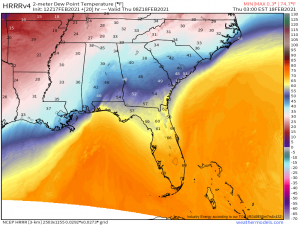
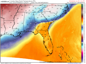
Wednesday’s threat will remain mostly confined to the immediate central Gulf coast and is likely to be the lesser of the two events. Currently, this area, from Louisiana to the western part of the Florida panhandle, is cold. When I say cold, I mean their lows this morning were in the 20s and 30s. Cold air has much lower dew points and is also stable air. Due to the location of the developing low, the warm front won’t lift very far inland, and where it does, it has quite a bit of work to do to advect in enough instability for severe storms. Abundant cloud cover prevails, meaning there will be little to no help from diurnal heating.
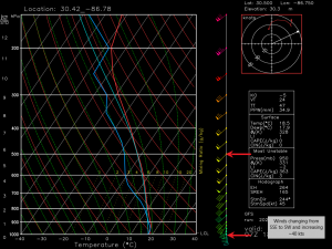
Still, the areas that do reach the warm sector could see dew points nearing 60 which is enough for some weaker destabilization. Lapse rates look to be less than impressive but deep layer shear of 50-60 kts plus CAPE in the 500-1000 J/kg range is likely adequate to support the formation of a few supercells. Storms that interact with the warm front boundary are most likely to intensify. Also, supercells able to form offshore in slightly more favorable conditions and move inland could pose a greater threat, much like we saw on Monday.
The main threats are expected to be damaging winds, however, where supercells are able to form, tornadoes are absolutely a possibility.
We are forecast to have good speed and directional shear supportive of rotation.
Don’t sleep on this threat. It may not look terribly impressive on paper but we have seen damaging tornadoes come from similar set ups. In fact, we saw that not two days ago in North Carolina where a high-end EF3 hit near Wilmington in the middle of the night. Use the rest of the day to make sure you have a plan in place to shelter and have MULTIPLE ways to receive warnings. Be as weather aware as possible tonight when you go to bed.
Thursday
Thursday’s event looks slightly more impressive as compared to Wednesday’s. The warm front will be able to lift further inland putting more real estate potentially in harm’s way and, as it is occurring during day time, any breaks in cloud cover will allow for further destabilization at the surface. As far as timing goes, we are looking at morning in the western Florida panhandle and then progressing eastward through the day before finally lessening toward the evening.
Lapse rates still look less than impressive which may limit destabilization but adequate shear of 40 to 50 kts and CAPE possibly topping 1000 J/kg can still support the formation of supercells. Though damaging winds mixing down from aloft are the main defined threat, should these supercells be able to form, tornadoes are also possible.
In the graphic I created outlining the threat areas, I identified two areas I felt might be most likely to see a more significant tornado threat than the others. These areas will see dew points rise near 70 and have the benefit (or detriment, maybe) of being close to the warm front boundary. These would be the eastern FL panhandle and southeast GA, perhaps more specifically SE GA as their threat comes later in the day and there is a greater chance for added destabilization due to any significant diurnal heating.
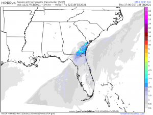
The supercell parameter isn’t off the charts, but it does show some concentrated possibilities. I know I say this all the time but, we’ve seen less ideal set ups produce before. It’s important to keep in mind that conditions don’t have to be perfect for severe weather to materialize. The two most intense tornadoes seen so far this year both came from separate, less-than-ideal, conditional set ups.
So that’s what we’re looking at, currently, for today and tomorrow. If you live in these areas, be on alert, especially for the overnight threat tonight. Overnight threats are always the most dangerous as people are generally less weather aware. Have multiple ways to receive warnings and take shelter if a warning is issued for your location.
Stay safe!!
