Multi-Day Severe Threat: Day One
Last week we took a look a set-up for what could be a potentially potent multi-day severe threat. Unfortunately for those in the way who aren’t storm chasers, it seems this event will play out as expected Monday, Tuesday, and Wednesday.
As with most severe threats, mesoscale details that work themselves out the day before/the day of can control how the event goes. For that reason, we’ll be looking at each threat in separate blogs the day before it occurs. I’ll cover Monday’s today, Tuesday’s tomorrow (with and update on any changes for Monday), and Wednesday’s on Tuesday (with an update on the current threat).
So let’s get right down to it.
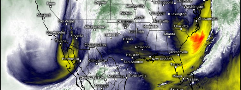
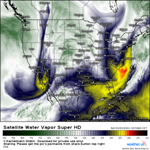
As we can see in real time via water vapor imagery, a deep-digging trough is swinging eastward. As it descends the Rockies, the system that will drive this severe threat will be born.
We know it will move toward eastern Texas by Monday afternoon and evening. But what will the atmosphere be like when it gets there?
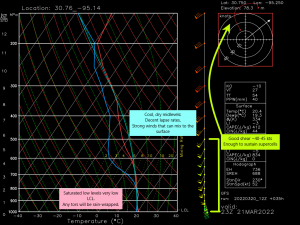
This is a GFS sounding from the weather.us site for just east of Bryan, TX around 5 pm central. It’s not high resolution like the CAMs (HRRR/NAM/etc), but we can still glean some important information about the state of the atmosphere from it.
- Ample shear is expected. That wide, arcing hodograph is an indicator of an environment supportive of tornadoes. The 40 to 45 kts of shear this sounding depicts is more than enough to sustain supercells. Additionally, winds back from the southeast, adding to low level shear.
- Low levels are saturated. This puts the LCL, or the level at which water vapor condenses into clouds, very low to the ground. Instability doesn’t have to travel very far before it enters the storm itself. Low LCLs are a common factor in stronger tornadoes.
- Low levels are saturated, part two – the moist environment means that any tornadoes that form will likely be rain-wrapped. This can be dangerous if you’re chasing or if you want “visual confirmation” before you take shelter.
- Cool, dry air exists in the mid-levels. This is good for steep lapse rates which help a storm strengthen and for damaging winds. As rain falls into this drier air, evaporative cooling takes place and the cool, dry air rushes to the surface. This could occur as a rear inflow jet in a bow echo or even a microburst.
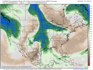
We touched on this a bit above when I mentioned the saturated low levels but, these storms are going to have access to quite a bit of moisture.
PWAT values are forecasted to be between 200 and 300% of normal in some places. We’ll be seeing values that are normally around in deep summer when you’re wearing the air rather than breathing it.
If you haven’t guessed where I’m going with this yet, here is it: flooding will be possible, especially if storms begin to train.
So the hazards on the table for Monday are damaging winds, flash flooding, large hail, and tornadoes – a few of which that could be strong. To add to this, the threat is forecast to materialize closer to sunset and then persist through the night. You know what I’m going to say next: have ways to receive warnings including at least one that will wake you!
Let’s take a look at the HRRR’s version of timing.
Scattered showers and storms will be possible in the morning as the warm front lifts north. These are generally expected to be elevated and under severe limits. The exception would be if any is able to become surface-based along the warm front.
These morning storms will keep the available energy down some so afternoon clearing will be key here. Where ever that clearing sets up, the strongest storms will be possible later on. Extra instability through heating = extra fuel.
By late afternoon, we see the strong storms begin to fire off the dryline in eastern Texas. This is the main show. Again, all hazards including flash flooding are on the table. The longer these storms can remain discrete before growing upscale, the longer the strong tornado threat will persist.
Upscale growth is expected as the night wears on and instability wanes. Damaging winds will be possible during this phase as will a QLCS tornado or two, but flash flooding may become the greater concern, especially if storm motion is parallel to the boundary as some models suggest.
To recap:
Severe storms are expected tomorrow. All hazards are on the table initially, beginning with a hail threat and a tornado threat, then transitioning to flash flooding with some damaging winds mixed in.
Timing is late afternoon through the overnight hours. Have multiple ways to receive warnings, including at least one that will wake you. Have your plan in place and your safe space ready in case you need to use it. Be ready to act quickly.
If there are any significant changes to the forecast, I will update in the first part of tomorrow’s blog. Otherwise, look for more information on Tuesday’s portion of the threat in a blog out later tomorrow.


Thank you!