Major Southeast Tornado Event Possible Through Thursday
If you live in the southeastern US, take time to review Meghan’s severe storm preparation tips here.
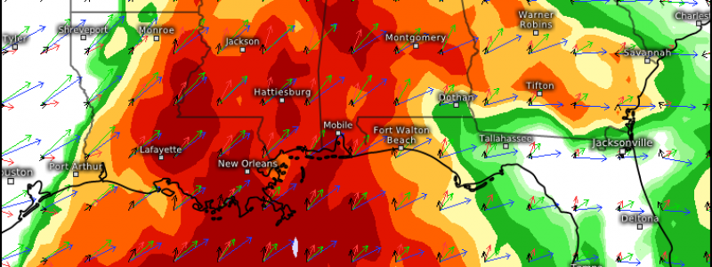
A very dangerous situation seems increasingly likely to evolve across the Southeast tonight into Thursday, with a substantial risk for numerous tornadoes, which could be strong or even violent, across a wide warm sector.
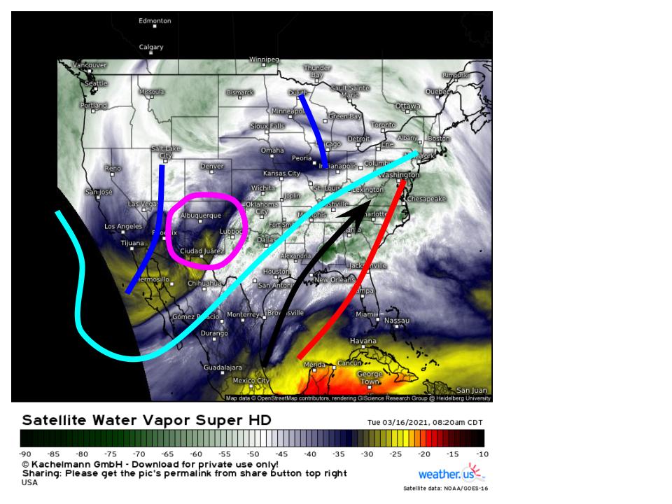
The set-up responsible will be triggered at large by a jet setup already apparent this morning, which can be seen on water vapor imagery.
A little bit of a messy hand analysis of the features of interest this morning reveals an expansive longwave spanning much of the United States, with two more consolidated packets of energy along the periphery. One, over the northern Midwest, is allowing the jet to stretch into a positive tilt, forcing ridging to the southeast of the longwave to assume a SW->NE orientation. The other, a much stronger closed low rounding the base of the longwave into the four corners region, is responsible for an expansive area of diffuse, immature cyclogenesis in the vicinity of New Mexico. As this closed low bowls east, the jet structure at large will promote persistent mass removal in an orientation that promotes low level SW-ly flow. Sensibly, several days of persistent southerly advection will precede the impulse’s ejection. This will set the stage for the surface development of a wide warm sector, which will be injected with some degree of kinematic support with the approach of the evolving Great Plains impulse. The seeds for a major severe thunderstorm outbreak are therefore planted, well ahead of time, in an unusual double-barreled jet orientation.
As the southwestern US impulse moves east, it will promote a multi-day string of severe thunderstorm risk as various orientations of forcing for ascent and kinematic support interact with long-fetch southerly flow.
Round 1: 7 am today (or whenever this blog ends up published) to 7 am CST tomorrow
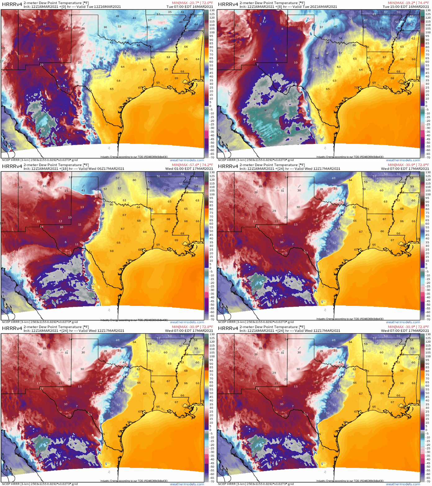
The first leg of sensible weather with our system will evolve as cyclogenesis continues east of the southwestern terrain, from New Mexico into the Texas panhandle. As often happens, inherent source differences between southerly flow originating in the high deserts of Mexico and southwesterly flow from the Gulf will promote a dryline, which will sharpen with time as the advection regime intensifies in response to increasing divergence aloft with the trough’s approach, eventually being overtaken by the increasingly consolidated cyclone’s cold front.
Moisture return limitations with westerly extent and robust convective inhibition will prevent much of a dryline-initiated storm threat this afternoon, but two distinct threats for severe storms, including tornadoes, will still find ways to develop into the overnight period. The first will evolve as increasing warm air advection amidst low convective inhibition promotes the development of scattered convective showers in the ArkLaTex vicinity a few hours after dark along a diffuse wind shift associated with a reinforcing warm front. These storms will be under the influence of increasingly powerful low level flow, and will be well sheared by a belt of strong midlevel flow ahead of the ejecting impulse. Deep moisture, fairly good kinematics, and localized helicity maxima in the vicinity of the warm front mean a strong tornado could occur with messy convection, which could be especially hazardous considering the nocturnal occurrence. Those in a swath from Louisiana and Arkansas into northern Mississippi should be sure to turn emergency alerts on for tonight!
A secondary area of mostly elevated storms will evolve near the cyclone over Oklahoma late tonight. Large hail and flooding will be the biggest threats with these storms, as they train to the north of a slow-moving warm front and exist within a zone of surface inhibition but powerful instability aloft.
By sunrise tomorrow, a cluster of storms with imbedded supercells will probably be waning in intensity over northern Mississippi and Alabama, as a band of showers and largely weak convective storms spans just east of the cold front from eastern Texas north into central Oklahoma. Arced between these features, the northern periphery of the most intense southerly flow will be marked with a few diffuse multicellular clusters. To the south, over much of Louisiana, Mississippi, and Alabama, and parts of Arkansas and Georgia, the morning will be partly cloudy, windy, and muggy. Those from the area will recognize this type of spring morning as a warning sign.
Round 2: 7 am tomorrow until 7 am Thursday
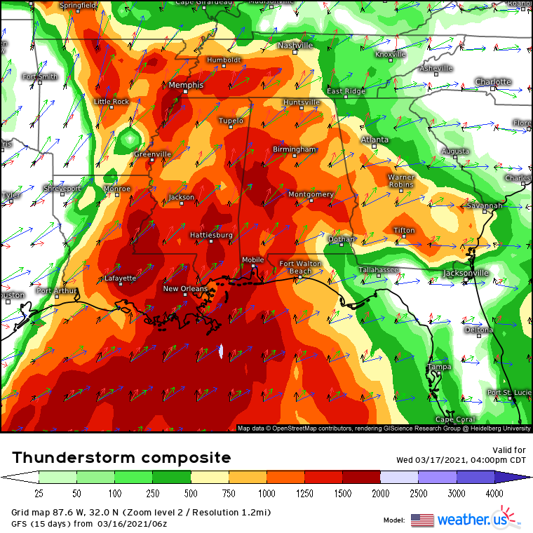
As the intense midlevel low pivots east tomorrow mid-morning, increasing divergence and flow aloft will both overspread much of the southeast with time. Without any clear forcing for ascent aside from minimal synoptic-scale incentive, precipitation should largely remain absent over the warm sector initially. In fact, scattered to widely scattered cloud breaks should allow for relatively robust surface heating, which will work with a stout EML and associated high lapse rates aloft alongside impressive advected surface moisture to encourage high-end instability for this time of year. The result will be an environment quite favorable for severe thunderstorms.
By the early to mid afternoon, amidst a steadily intensifying low level jet and well to the east of the occluding cold front, clusters of multicellular convection should begin firing in earnest as convective temperatures are exceeded in the minimally capped environment. With cool midlevels and impressive dewpoint return, instability will almost certainly not be the limiting factor. Robust updrafts, with unusual confidence, will likely develop.
They will move quickly northeast, as impressive shear encourages updraft organization and plentiful instability maintains healthy inflow. Fairly favorable, looping hodographs due to a moderate low level jet will promote rotation of these long-lived updrafts where they can remain discrete, which shouldn’t be much of an issue given diffuse forcing over the open warm sector. It is, at the moment, too early to say exactly where in the expansive warm sector these cells could develop, given a lack of forcing and the likelihood of dominance from rain-cooled outflow boundaries inherently unpredictable this far out.
But it seems probable that several of these storms, where they do develop, could produce long-track strong to violent tornadoes given the parameter space at hand.
Given the excess of instability and shear, the ‘least favorable’ factor for high-end storms will probably be the fairly moderate low level jet, not as much a limitation as it is a lack of support for violent tornadoes. This means that locally enhanced or turning low level flow will promote the highest-end impacts, which will probably be seen along both topographical support and any atmospheric boundaries that form as a result of earlier convection.
So, during the afternoon, several clusters of strong to severe storms could develop, several of which could spin up into supercells capable of producing strong tornadoes. Where helicity, the limiting factor, is locally maximized, a violent tornado could occur.
This equation will shift with sunset.
As night falls, tornado threats typically wane. That will not be the case tomorrow night. Rather, an increasingly strong low level jet will develop into the overnight, and the unusually impressive instability will be sufficient to overcome the loss of diurnal heating. The result could be an incredibly dangerous situation should discrete convection exist to take advantage of a parameter space extremely favorable for strong to violent tornadoes amidst the loss of situational awareness that comes at night. Please, if you live in the southeast, make sure you have multiple ways to receive weather warnings. Make sure these warnings have a way to reach you while you sleep. The severe threat over Alabama late on Wednesday could well end up one of the most volatile overnight tornado outbreaks in recent memory, if discrete convection persists.
This is not a ‘perfect’ tornado outbreak. But it is about as favorable as a setup can get for significant overnight tornadoes that overlap with population centers of the Southeast.
To the west of any of these dangerous discrete storms, linear convection along the surging cold front will bring a threat for widespread wind damage and scattered imbedded strong tornadoes, especially overnight. Even if the discrete storm mode ends up faltering, expect fairly significant impacts with this line of storms. These impacts will be amplified where stronger line segments move through areas previously impacted by evening tornadoes.
The severe threat, including the possibility for numerous strong tornadoes, will continue after 7am Thursday across the southeast and mid-Atlantic. Expect more on that tomorrow.
Thanks for reading. Please be sure to stay weather aware, especially tomorrow into the overnight. Stay tuned to the national weather service and our twitter for more. Fortune favors the prepared.


Jacob – very helpful context – – thanks!