Long-Duration Nor’easter Continues Today
Welcome to Day 2 of our long-duration Nor’easter! Hope y’all are enjoying your snow. The storm has underperformed in some areas (looking at you, DC) and is set to overperform in others. If you’re interested in a seriously in-depth analysis of the storm, check out Jacob’s blog from Saturday. I will just be adding on today to include recent developments.
Yesterday’s snowfall was just a warm-up. We will see our heaviest rates today as the coastal low intensifies.
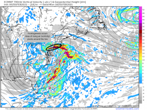
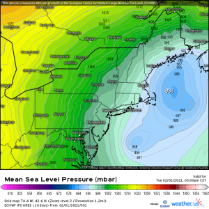
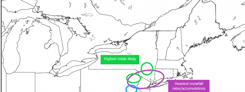
As the low forms off the east coast today and begins to deepen, it will undergo frontogenesis. Frontal forcing will allow for a band of rising air to occur north and west of the low. This area will then pivot around the center while launching extra moisture aloft to enhance snowfall. Locations underneath this band will experience snowfall rates of 1 to 3 inches an hour and the heaviest storm totals.
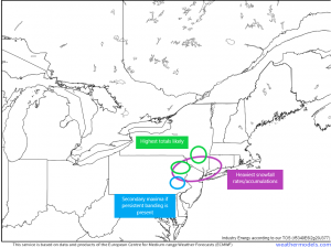
I’ve outlined above what I’m expecting as far as that persistent, heavy snowfall goes. The lift associated with frontogenesis will pivot through W CT/SE NY/E PA today. However, guidance also suggests that there could be some persistent banding over SE PA as well so I’ve added that as a spot to watch. Our highest totals will be seen in the elevations of the Poconos and Catskills where we get an assist from orographic lifting. Here we could be looking at accumulations of up to/locally over 2 feet.
You may have noticed that New York City is included in the area of heavy banding. For the city, this will be a high impact storm. Over a foot of snow is expected and will likely shut the city down to a degree for a day or two.
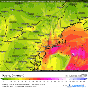
As this low gets going, the winds will intensify as well. It’s not outside the realm of possibility that we could be looking at blizzard conditions, especially along the coast, later today. Quick review: Blizzard conditions occur when frequent gusts/sustained winds are 35 mph or greater and visibility is reduced to 0.25 or less for a period of three or more hours. So, you know, miserable conditions. If you can stay home today, do so. It’s not a great day to be out and about.
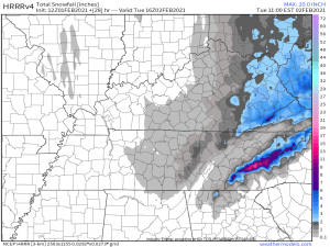
This storm’s effects isn’t just confined to the northeast, though. The wrap around moisture will trigger an upslope snow event for the Southern Appalachians throughout the day today.
This will also be a long-duration event with snowfall occurring continuously over the next 24 hours or so. Though the valley areas will likely see at least an inch, the big show will be in the Smokies where over a foot is expected in the highest elevations. The Blue Ridge sees accumulations as well, though, again, the heaviest will be seen in the peaks right along the TN/NC border. Places like Mt. LeConte, Clingman’s Dome, Newfound Gap, etc., are the bullseye this time.
As the storm perpetuates northeastward tomorrow, a secondary area of low pressure will form southeast of the primary low and essentially take over. This will continue the threat of heavy snow into northern New England, though totals will be somewhat less than what is expected in the lower Northeast.
The secondary low brings with it air that is a bit warmer than the air found in the primary low. We will need to watch the coastal areas from Cape Cod through Maine for mixing issues as warm air aloft may put a damper on an all-snow event and cut down on total accumulation.
All that’s left now is to sit back, watch it all unfold, and most of all, ENJOY it! If you like snow, anyway. If you’re reading this from an area set to get a lot of snow, please comment later with your totals. I’d love to see how accurate our predictions/analysis were!
