Iota Rapidly Intensifies Over Southwest Caribbean
It is November 15th, 2020, and the 30th storm of the Atlantic hurricane season is rapidly intensifying, with landfall more than a day away.
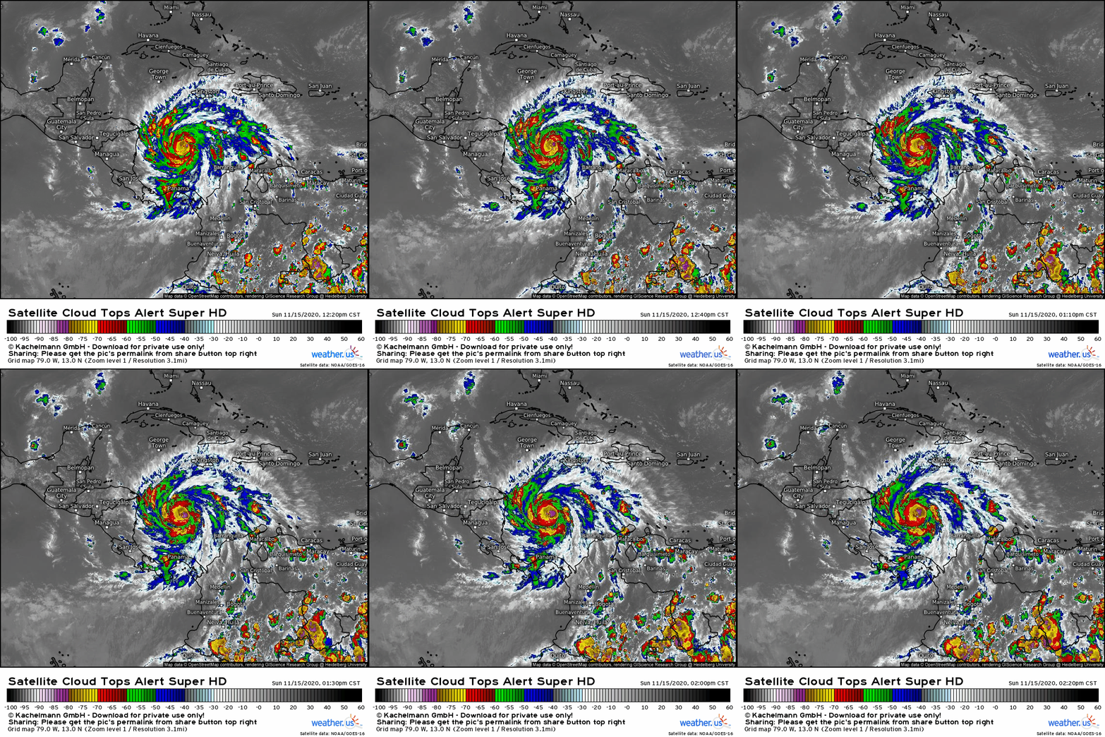
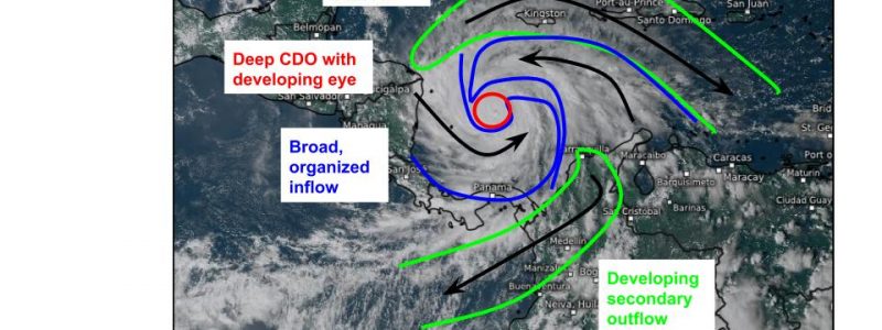
Iota’s CDO itself is quickly organizing this afternoon, with a “donut” of -70 to -80 degree cloud tops surrounding a clearing eye. Deeper convection, to -90 degrees, is rotating around the eyewall, and I expect a solid ring of -80 to -90 degree cloud tops to soon surround a clearing, small eye.
This CDO structure tells me that Iota will likely make a run at major hurricane status soon, if it is not already almost there. The NHC predicts an almost unheard of (or maybe actually unheard of) 50mph wind increase in the next 24 hours, and it’s clear why.
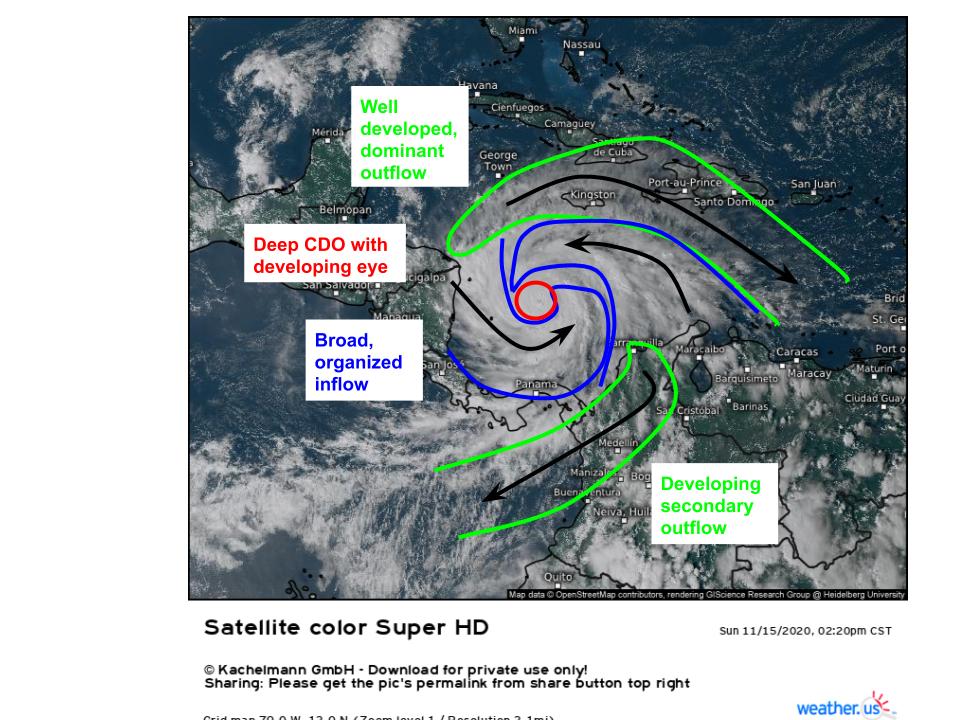
Zooming out on the storm, it’s clear why Iota is able to rapidly strengthen today. With the help of a well-oriented midlevel anticyclone, the storm has been able to organize a very favorable broad structure for continued intensification. Satellite imagery shows two large feeder bands, a well-established outflow band to the north, and a developing outflow band to the south.
The mass removal from the vertical column that this kind of dual-outflow structure allows will really help push the storm to rapidly intensify. Not like Iota needs much help. The storm exists in an environment of very warm SSTs and extremely low wind shear (largely due to the same anticyclone that’s encouraging the impressive outflow regime). This very favorable environment will largely continue until Iota reaches the Nicaragua/Honduras border, likely a little north of where Eta made landfall, late tomorrow night or early Tuesday morning.
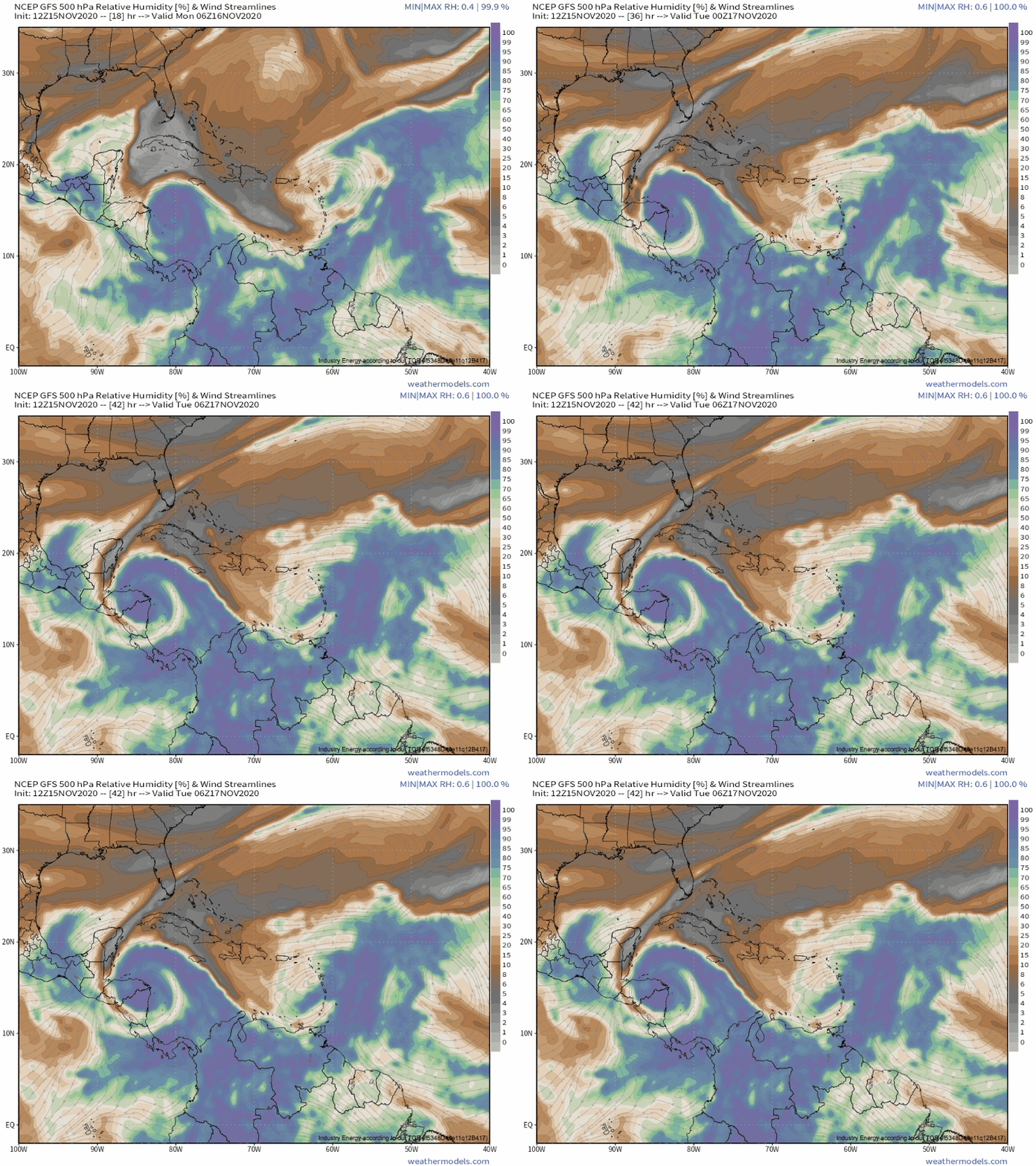
There is really only one thing I can think of that could prevent continued quick intensification until landfall, besides a hard-to-predict eyewall replacement cycle, is the potential for dry air to intrude into the storm’s outer circulation starting tomorrow evening.
With limited shear and what will likely be a very well organized CDO, it’s unlikely this will have any impact on intensification at all. However, if the dry air intrusion threat corresponds with sneaky shear or a strong eyewall replacement cycle, it’s possible that the storm could noticeably weaken before landfall. This is unlikely, but should be noted.
With the disclaimer out of the way: it’s becoming increasingly obvious that the Honduras/Nicaragua border region is at risk of yet another major hurricane landfall, likely at an intensity of category four or maybe even five. Iota will be making landfall quite close to where Eta did, which should magnify impacts from surge and wind. As these impacts include extreme winds and 10-15 foot surges likely near where the center moves onshore, this will be a truly devastating one-two punch of major hurricanes.
But, as I’ve been writing about, the worst impacts of Iota probably won’t be in the wind and surge, as devastating as they may be. A catastrophic episode of rain appears likely to impact Honduras and parts of Nicaragua, with 20-30+” not out of the question, especially across near-coastal mountainous terrain. You can read my blog from yesterday if you’re curious about the mechanisms at play. As much of this will fall on areas recently inundated by Eta, it is unfortunately becoming clear that a major humanitarian crisis is possible.
To reiterate a little of what I talked about yesterday, the main culprit will be persistent northerly advection of very moist tropical air into the favorable geometry of coastal Honduras, where it will be lifted into rain along the mountainous coastal terrain. As mountains don’t move, very significant rainfall will be possible where topography is favorably oriented to the coast.
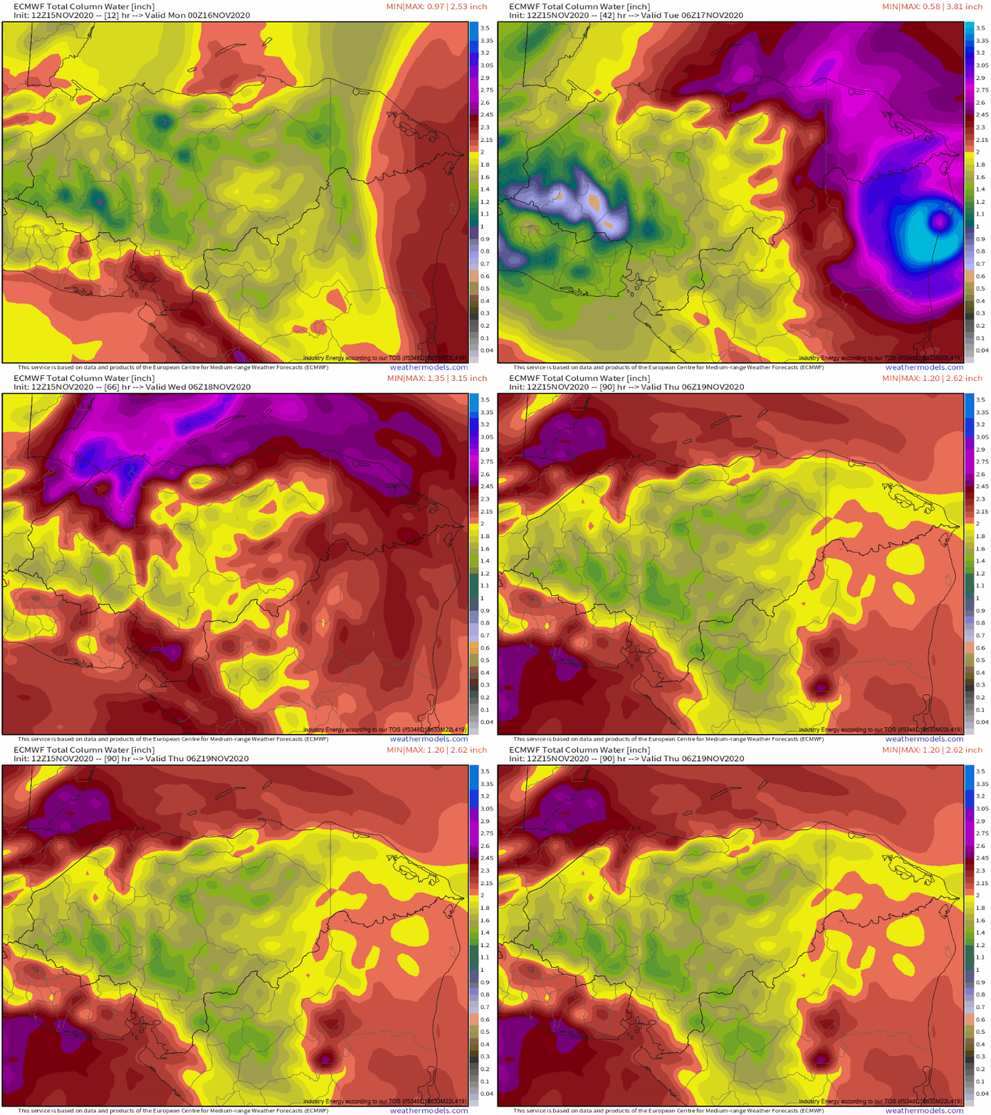
The only real update with the rain is that my scenario #2, with a landfall near the Nicaragua/Honduras border, is becoming more and more locked in. This, as I mentioned, is not the worst case scenario of a coast-parallel storm, but it’s still likely to be very bad. Many models have a wide swath of 20-30″ of rain across northern Honduras and northeast Nicaragua.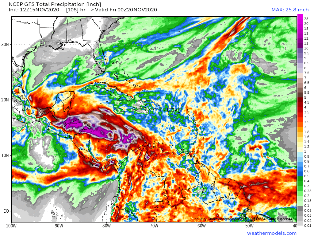
Sadly, this will likely prove tragic, as areas already quite vulnerable from recent inundations and mudslides with Eta see extreme additional rain. I can’t really see a scenario in which many landslides and widespread inundation don’t lead to widespread destruction, damage, and death.
Iota is rapidly intensifying this afternoon, with an increasingly organized core coinciding with a large-scale structure very favorable for continued strengthening. For the most part, conditions will remain very favorable for additional deepening, and a major hurricane landfall of around category four intensity will be likely near the Nicaragua/Honduras coast in around 30 hours. Iota will bring devastating wind and surge near its landfall site, but the most serious threat should be another round of potentially catastrophic rainfall, and it is appearing unfortunately likely that parts of Honduras and Nicaragua will see tragic outcomes as 20-30 inches of rain fall where Eta only recently dropped similar totals.
