Iota, A Potential Catastrophe, Lurches Closer to Landfall in Central America
I will not mince words here: there is a significant possibility of a disastrous, tragic humanitarian crisis in parts of Central America, likely centered on Honduras, with Iota.
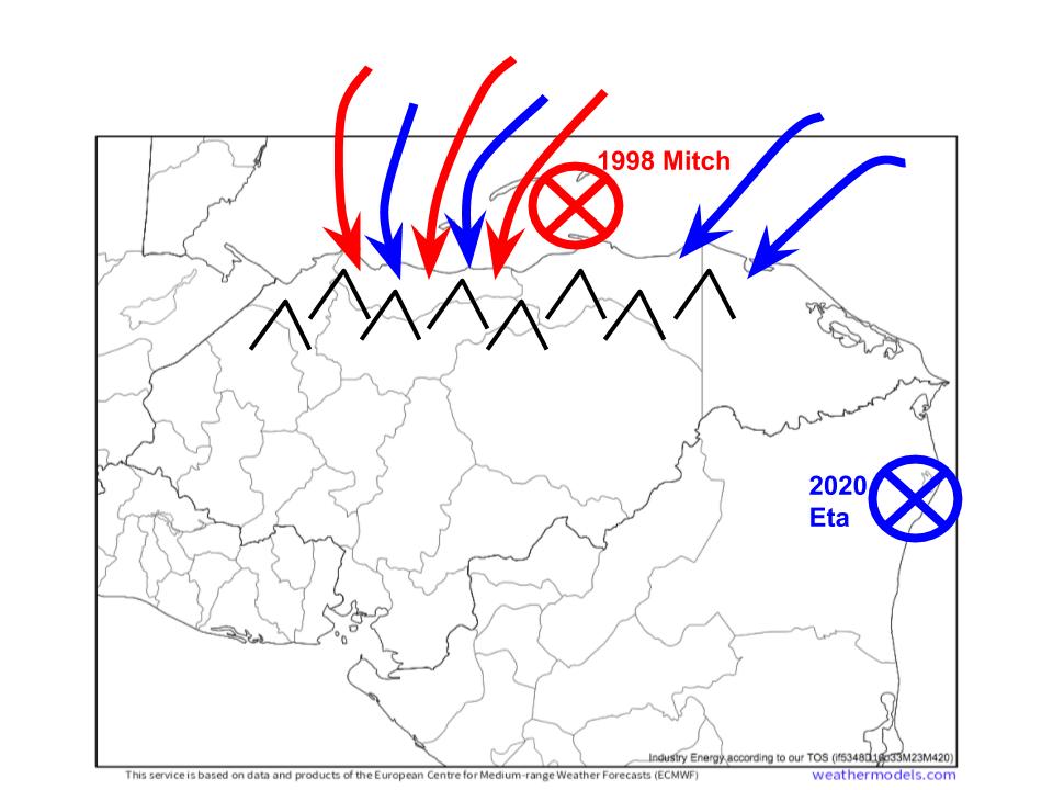
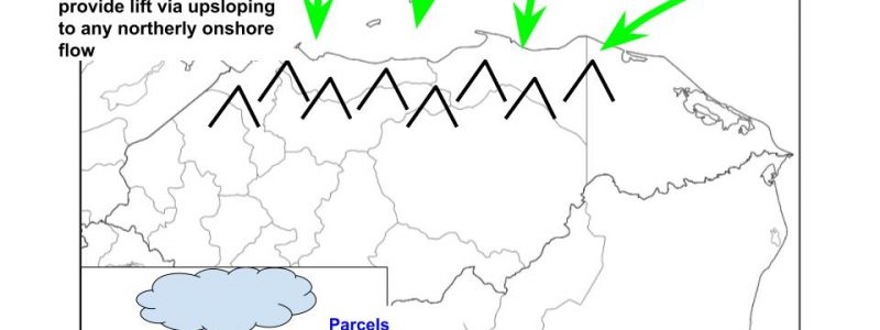
Honduras’s topography and coastal geometry make it unusually vulnerable to very heavy rain events given northerly, onshore flow. Any of this flow will typically be very moist, originating over the warm waters of the southern Caribbean. And the mountainous terrain just onshore can serve as lift, forcing parcels to condense water vapor into rain in the same way a cold front might over Indiana. This all means that the coast of Honduras can act like a machine of sorts, turning an input of northerly flow into an output of rain. Long lasting northerly flow, then, can cause significant rain with catastrophic flooding relatively easily; unlike over, say, most of North America, no significant moisture advection or unusually slow-moving atmospheric lift (ie, front) is required. 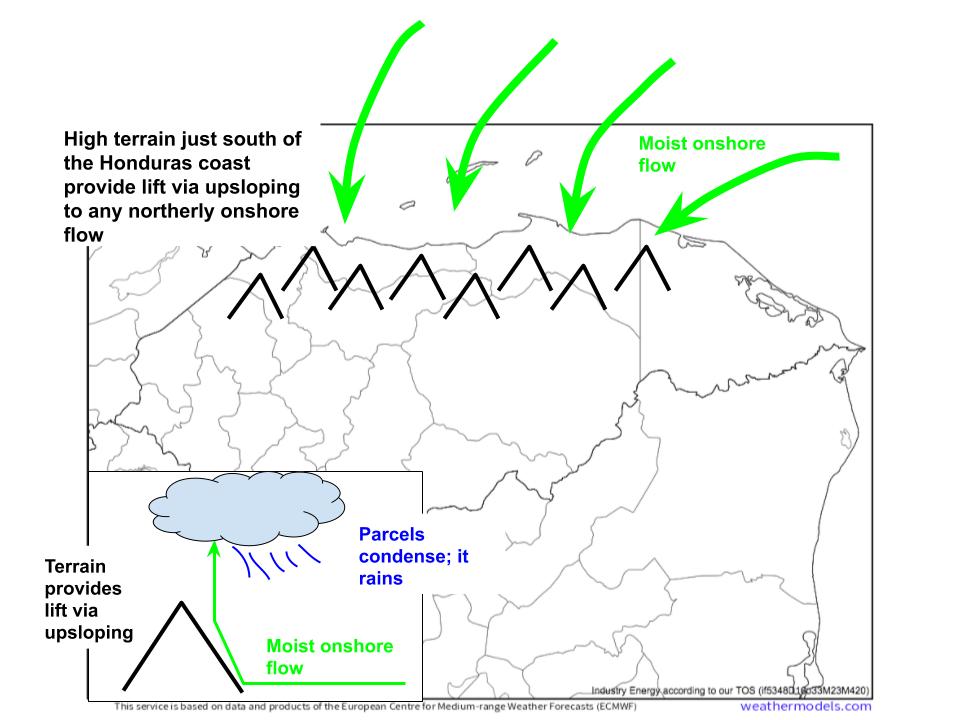
Luckily for Honduras, there aren’t that many things that can cause long-lasting northerly flow at 15°N. Really, tropical cyclones are the only things that can, and there’s a pretty small list of ways these storms can track to produce long-lasting northerly flow over coastal Honduras.
One of these ways is to stall near northeast Nicaragua or east Honduras. It happened with Mitch in 1998, and again with Eta last week. When this kind of well-positioned stall happens, moderate northerly flow extending well away from the cyclone’s center can pile moisture against the mountains of Honduras for as long as the storm stays in position, and as long as the circulation remains robust. Predictably, this kind of input into Coastal Honduras’s rain machine can prove devastating: in Mitch, well over 10,000 people died in the deadliest Atlantic hurricane disaster since the 1700s.
Evidently, a stalled storm can be a nightmare for Honduras if it meanders in the right location relative to the country’s northern coast for persistent onshore flow.
There’s one way to get this kind of long-term input of northerly flow without a stall, too. It requires a tropical cyclone to move parallel to the northern Honduras coast, with the circulation’s center close enough to land to allow an onshore flow component to its west. This happened with Fifi in 1974, and the results were once again predictably devastating. Between 8000 and 10,000 lives were lost as, once again, the Honduras rain machine saw a long-lasting input of strong onshore flow.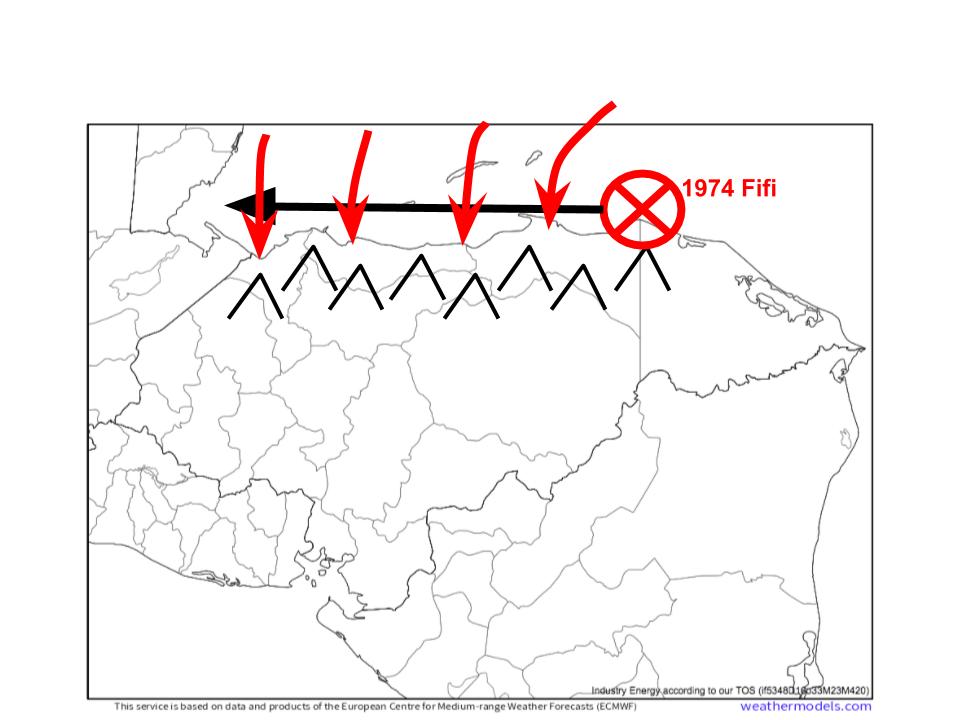
Now, let’s look at Iota. The storm is beginning to organize an inner core as I write this blog, and the atmosphere and ocean are favorable for continued intensification. I discussed the details in my blog the other day. There are really four potential track options for Iota, at least as far as the subject of this blog (catastrophic flooding potential over Honduras) is concerned. I’ll discuss each one briefly, and then talk about where the storm will probably actually end up.
The first possibility is a track directly into north-central Nicaragua. The moderate forward motion and rough terrain of Central America would cause a quick decay of Iota’s circulation, keeping northerly flow limited over Hondura. This would probably be the best case scenario, but unfortunately seems unlikely at the moment. The steering quirks I mentioned in my last blog, in which a stronger storm would end up further north, mean that this option would most likely occur if Iota never intensifies very much. This simply doesn’t seem likely at the moment, unfortunately.
The second possibility is probably the most likely. It involves landfall near the Honduras/Nicaragua border, and would feature high-end, but not worst case, rainfall, as Iota would be able to wind down some while tracking over land, reducing the intensity of onshore flow. Let me be clear- this would still be disastrous, and would likely see catastrophic flooding and landslides as an additional 10-20″ of rain fell on top of areas that just saw extreme totals last week. It’s what the NHC is forecasting, and it would likely cause widespread destruction, exacerbating the tragedy of Eta.
The third possibility is even worse, and seems to be becoming more likely, although still not as probable as the second possibility. In this truly worst-case scenario, Iota would stay either just offshore or just inland while moving parallel to the northern Honduras coast. This is what happened with Fifi in 1974, and it could cause one of the worst hurricane-spawned humanitarian crises in the history of the basin, with truly catastrophic rain falling on top of areas that just saw widespread destruction at the hands of Eta.
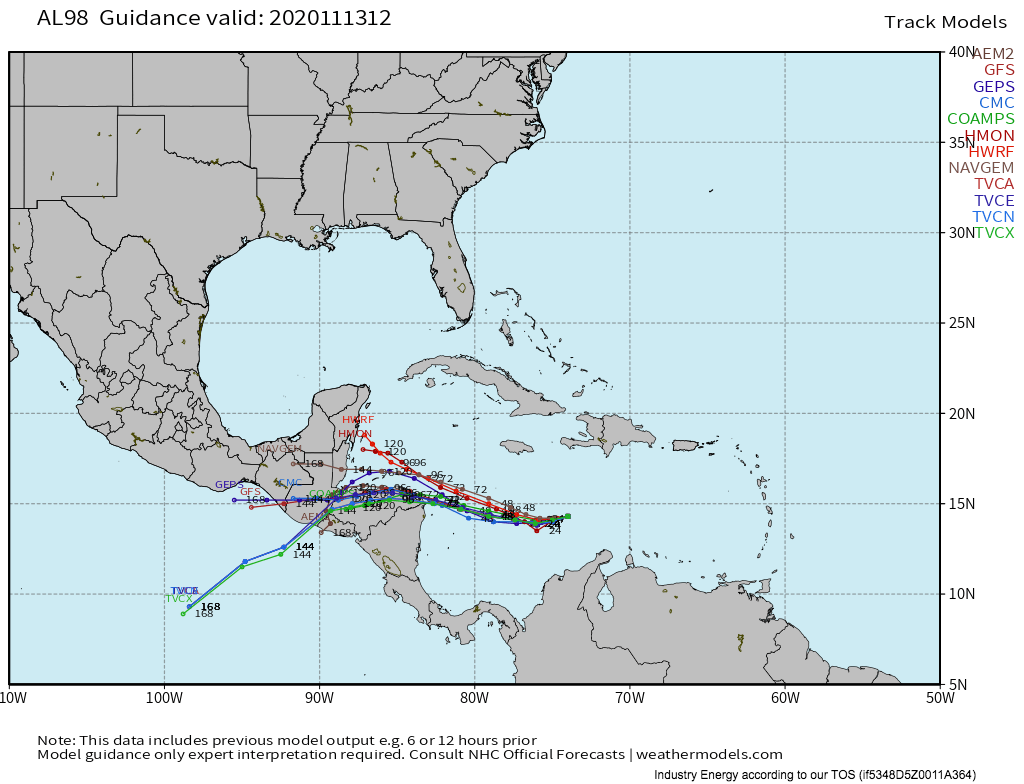
There’s actually an increasing trend for hurricane models to show this kind of track. The most recent run of the HWRF even ended up shifting significantly to the south, and now shows a similar coast-hugging track for Iota.
Finally, the fourth track option is for Iota to intensify quickly over the next couple days, and remain far enough north for Honduras to avoid the most catastrophic scenario. As Iota continues to stay disorganized today, this is also falling out of favor; models that once showed it, like the HWRF, have backed away.
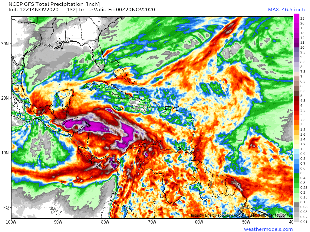
Many global models have either option 2 or option 3, and predictably show extreme precipitation over Honduras and parts of Nicaragua. 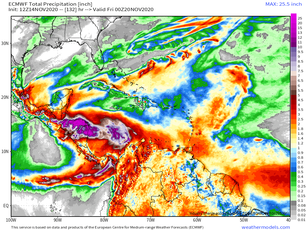 Link: https://weathermodels.com/index.php?r=site%2Fmodels&mode=animator&set=9-km%20ECMWF%20Global%20Pressure&area=Caribbean¶m=Total%20Precipitation&offset=0&thumbs=1
So, there we have it. Honduras, still reeling from a storm not too different from Mitch, could face a storm similar to Fifi less than two weeks later. Should this happen, the impacts will be almost unimaginably catastrophic, with widespread mudslides, flash flooding, crop damage, property destruction, and death. The most likely track options for Iota are either very bad or very very bad for Honduras.
As Iota threatens to drop another round of very significant rainfall over areas that just saw devastating flooding, a true catastrophe is possible. In my years forecasting and observing weather, it is hard to think of a more potentially tragic event. We will be sure to keep updating you all here and on our twitter; also be sure to follow the advice of local officials.
