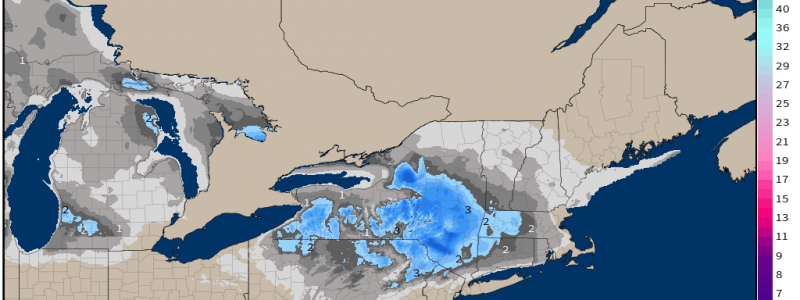
Interior Northeast Winter Event Sunday-Monday.
There’s been a considerable adjustment not just by ensembles, but deterministic models as well for tomorrow’s wintry event across the Northeast just this week!
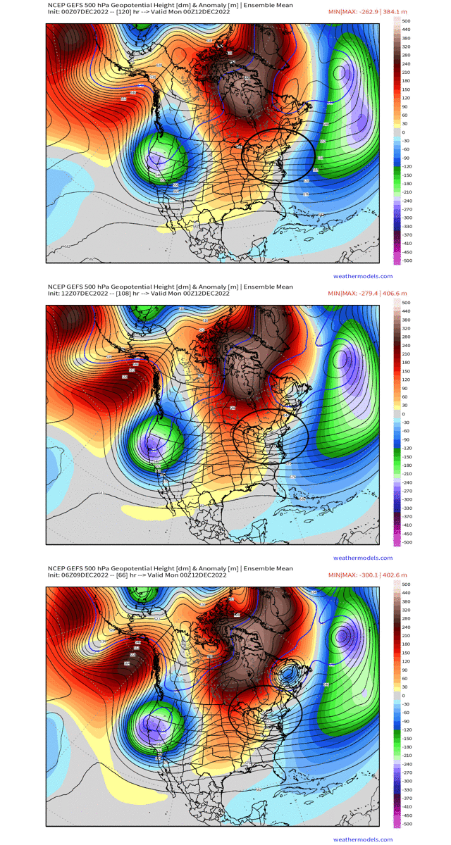
Just compare the last several run cycles of the GEFS for instance, and notice how the entire height pattern has shifted to a much more amplified, and less progressive flow. This has a direct consequence downstream across the Northeast as I annotated to where to look, as the ULL now becomes more apparent across the Northeast with stronger ridging upstream across the northern Plains.
With that being said, lets dive into the meteorology of the setup, and what we can expect through Monday!
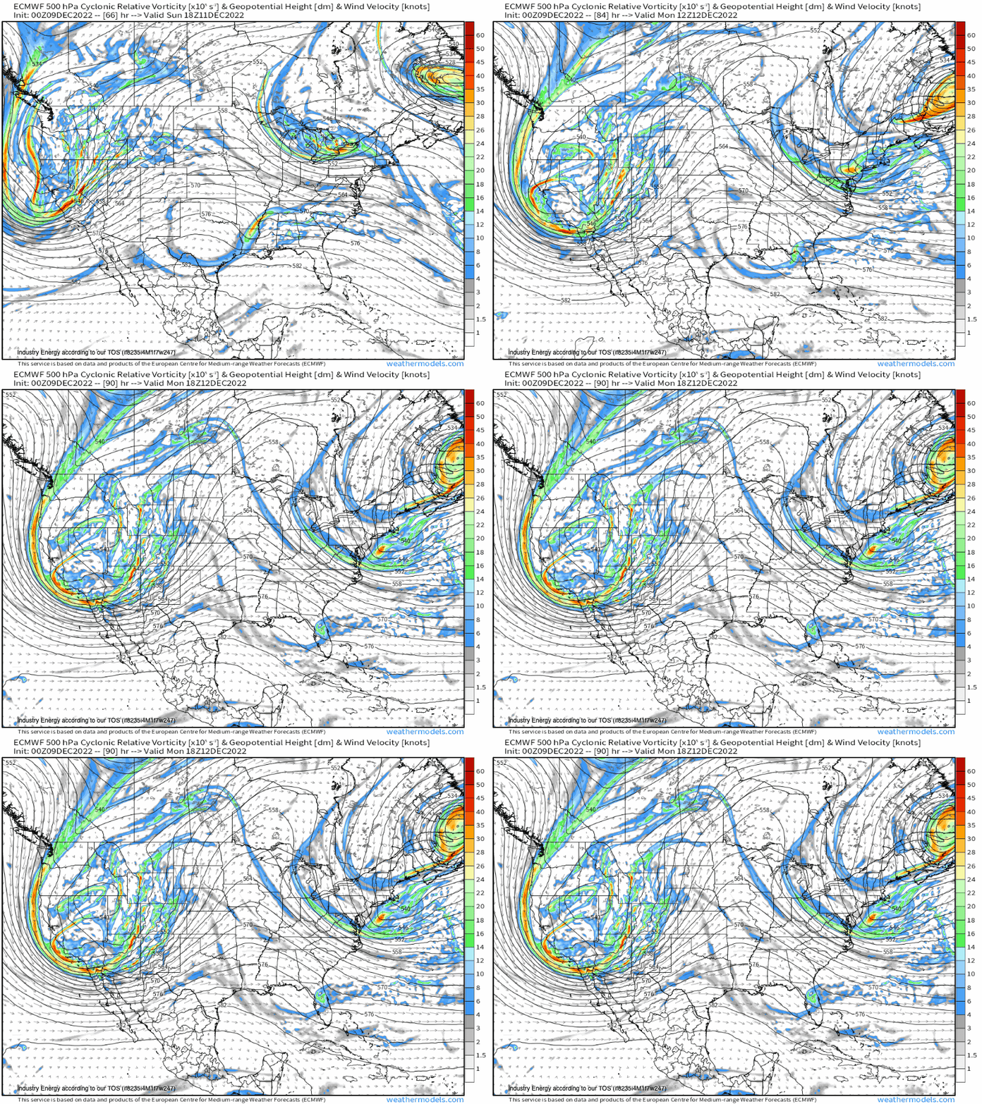
A vorticity max will dig in from the west, and essentially cut-off across Lake Erie or within the vicinity as we look at the ECMWF 500mb vorticity progression. Through Sunday evening, the vorticity max slides in a NW to SE fashion from through PA and into NJ, before shifting off the coastline of NJ and south of southern New England by Monday. However, recent trends actually now have gone away from the robustness of the ULL (showed the vorticity max deeper and stronger), and even shifted a bit weaker and elongates it as the ECMWF does here. This has direct implications at the surface.
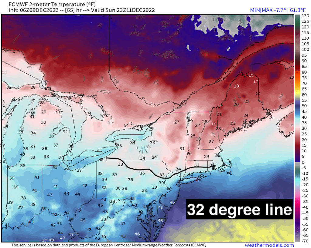
At the surface, this is a tricky setup for multiple of reasons. First, where the positioning of the mid and lower-level lows setup, influences the temperature profile. If it can dig a bit further south, those north and west of the trough see more cold air advection and better dynamics to work with to an extent. However, there’s likely going to be mixing with this as well, and of course rain to the south. Here I’ve outlined the freezing mark, and we can see this essentially follows climatology rather well, with interior favored. Second, surface temperatures up and along I-95 and up toward I-80 that runs across central PA into northern NJ will be in upper 30’s to lower 40’s. Outside of the higher elevation of NE PA and into extreme NW NJ, many places are above freezing. The general timing of this event will be between tomorrow late morning until tomorrow evening from west to east. Snow looks to start around early afternoon for those places with supportive temperatures.
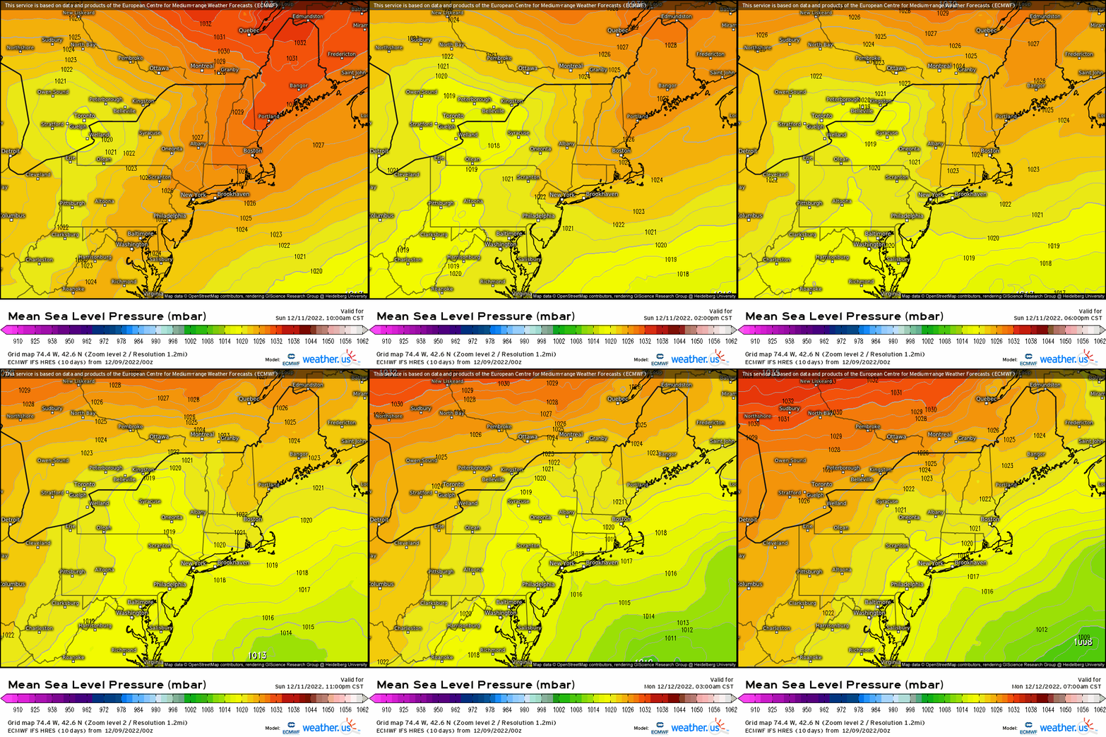
As the upper low shifts southward, and with it the surface low pressure is “forced” to transfer offshore as a result of high pressure to its Northeast, this causes some warming in between as well via warm air advection. We can see this process happen tomorrow evening of the transferring of the low pressure offshore. Notice how the original low tracks up toward western NY and then we see a secondary low pressure form east of the Delmarva.
Typically with these types of setups, snow and frozen precipitation is favored north and west of the major metro areas such as Philly and NYC, but in this case closer to the Poconos, north and west of the Lehigh Valley, and into the Hudson Valley. Let’s compare two soundings from tropicaltidbits in this case, as the vertical profile is VERY important when forecasting precipitation types! The one on the top is from northern NJ, and the bottom is from NE PA. Notice the difference between the two; the difference lies in the surface temperature and dewpoint in the vertical relative to that 0*C isotherm. Across NNJ, we see the entire sounding fully saturated with decent lift in the dendritic growth zone (DGZ), except it’s too warm at the surface causing snowflakes to melt once it approaches the lower few thousand feet. Across NE PA, the entire sounding is saturated from the surface to 500mb, so we have plenty of moisture for ice crystal formation and it’s plenty cold enough! Notice at the surface, it remains just around 32 degrees, if not slightly below. An interesting phenomenon occurs when heavy precipitation and low level dry air occurs in tandem – this is called “wet-bulbing”. Simply this means that because of the dry air and evaporation, the temperature decreases and allows for frozen precipitation to occur as it can change wet to frozen! This is expected to occur for places like NE PA, Hudson Valley, and into southern New England as moisture advection and saturation occurs aloft prior to the main system.
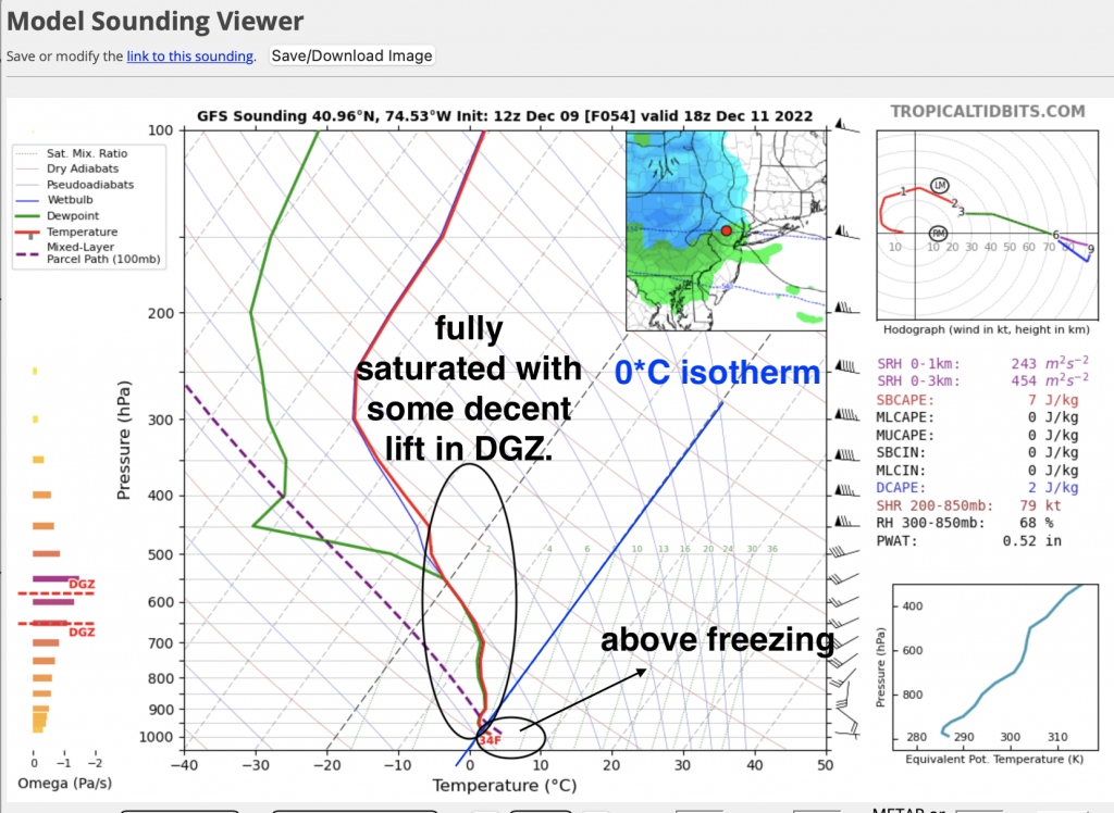
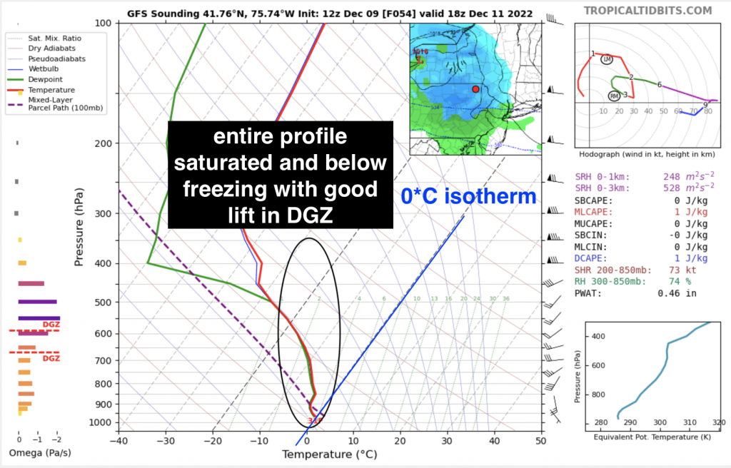
In order to get places like NNJ to look more like interior PA or the lower portion of NY, we’d need to see a big adjustment with the entire disturbance aloft; however, that doesn’t appear to be the case.
What we’ll closely monitor in fact, is as the new surface low develops offshore, this causes cold air to advect in behind. If enough moisture lingers in the vertical and in the “dendritic growth zone” (where snow forms and grows depending on several factors), we can maybe see rain change to some snow further to the south and east, although limited in extent depending upon how much moisture is left and if enough lift is present. We may even be dealing with an inverted trough (a trough axis that has an area of enhanced Precipitation and are tough to forecast, but we look for a “finger” of extending vorticity) late tomorrow night into Monday. That could allow for snow to linger as well, and even get down into the lower elevation regions.
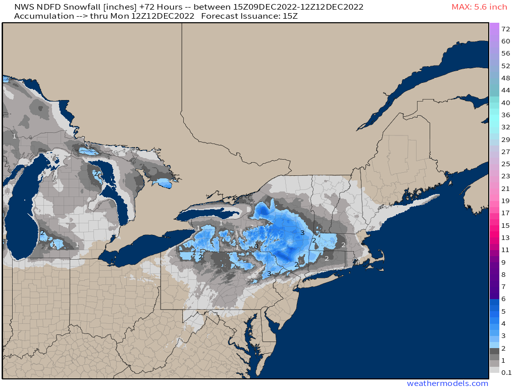
Again, at this juncture, the best chance for at least a few inches of accumulating snow looks to remain across places like along and N/W of Reading up to Allentown and Scranton. This then becomes more favorable into Binghamton and into southern N.Y., and western MA and NW CT. The NWS forecast I think is the best consensus and outline for where we’ll see the transition zone between rain and a few inches of snow through Monday morning! We’ll also have to watch on the backside as the low pulls out to sea for some snow showers to stream in!
For those that don’t see snow, there’ll be plenty of opportunities later this month especially with how the long range is looking!


