Interior Northeast Faces Significant River, Flash Flooding Threat
An extreme moisture infusion of unusual longevity and ferocity will lash the Northeast today into tomorrow. Where topographical lifting, significant snowpack, and convectively enhanced rainfall rates align, a round of flash flooding and river flooding may occur. Indications are that it could be the worst flooding event in many years for parts of the region.
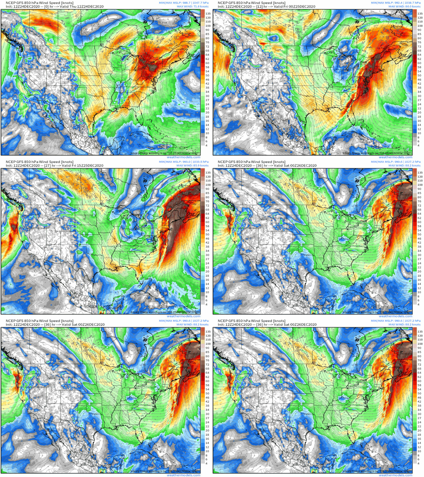
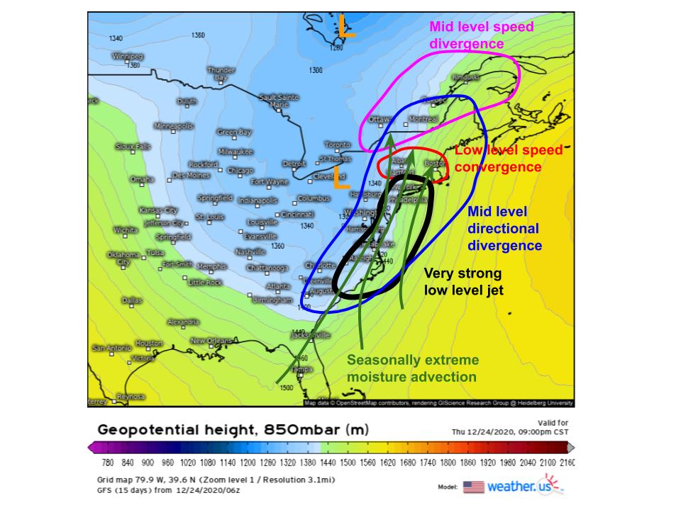
The stage for this event is set by an unusually high-amplitude, intense synoptic-scale atmosphere, even for this time of year. It’s been discussed in great detail by Meghan and Jacob over the past couple days, so I won’t spend much time on the background for this blog. The important part: a very deep midlevel trough, and a series of associated shortwaves, has created an environment in which a pair of low level cyclones can strengthen while moving with a large northerly component. This large northerly component, in turn, means that the associated low level jet remains in place for longer than typical. As this low level jet pumps subtropical moisture into the northeast, moving relatively slowly, the stage is set for a significant rainfall event.
Even for a part of the country that is well-positioned to see powerful atmospheric river events, typically once or twice a year during meteorological fall or winter, this one will be unusual for a couple reasons.
First, the ‘dual cyclone’ setup, along a very stretched out midlevel trough, will allow for an unusually long duration fetch of subtropical moisture, with an unusual intensity. Think of the second cyclone as reinforcing the wind field of the low level jet, which in turn increases the injection of moisture into the northeast. Meanwhile, the high amplitude of midlevel flow means the second cyclone will track largely parallel to the first cyclone’s low level jet. This all will yield an unusually long duration, high moisture influx event.
Watch the low level jet intensify as the secondary cyclone gets going over the mid-Atlantic:
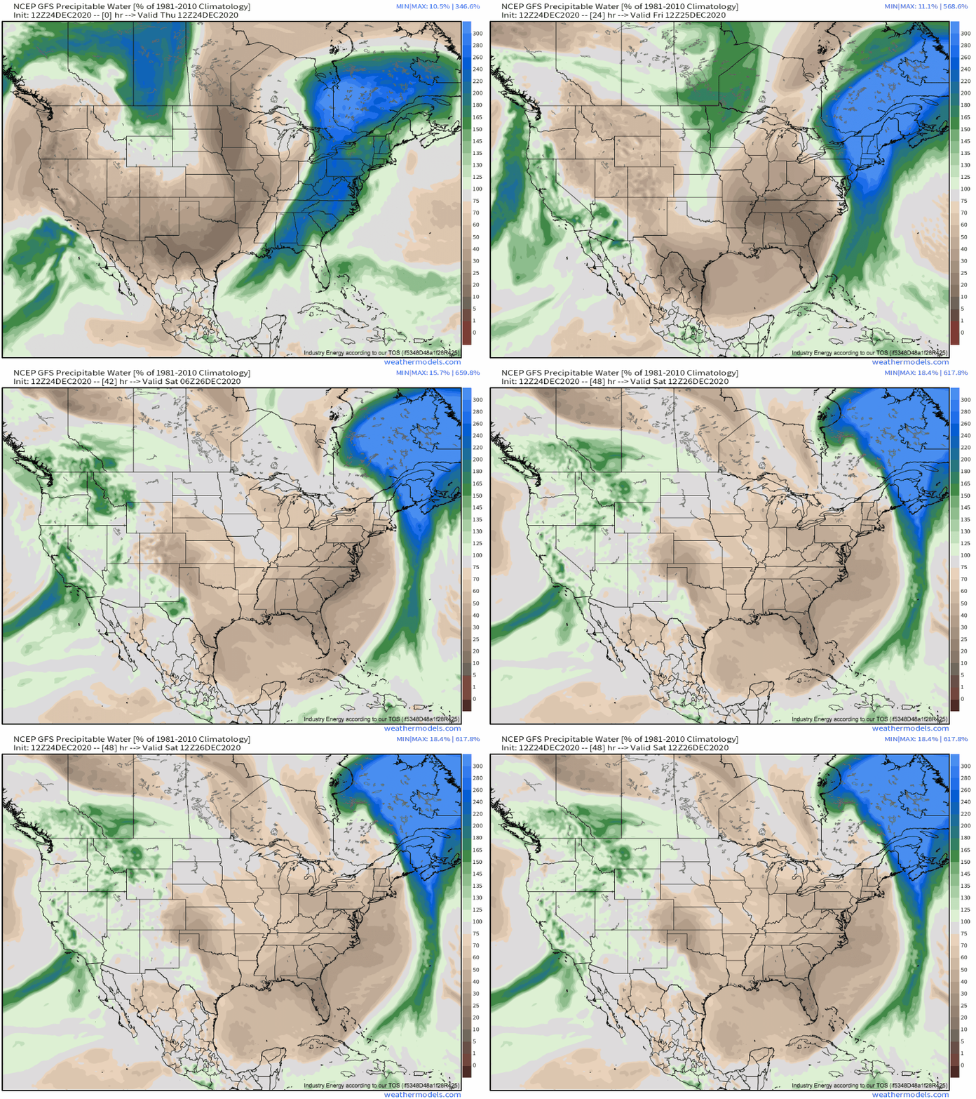
This intensifying LLJ will pump extremely anomalous moisture into the northeast. Watch precipitable water anomalies balloon as the LLJ enhancement siphons deep subtropical moisture at an increasing rate, and notice how long some locations spend under >300% normal PWAT with this storm:
As this extreme moisture influx races inland over the northeast, it’ll fall as heavy rain wherever parcels can be lifted to condensation. Synoptic scale lifting will play an important role, spreading scattered to widespread showers throughout the region even absent of any more defined atmospheric or surface based convergence.
Atmospheric convergence at a more mesoscale will also play a big role. This will be most significant along the cold front, which will provide deep lift necessary for high rain rates. It is even appearing increasingly likely that a convective squall line will develop along the cold front, bringing a round of very heavy rain to much of the area. But cold fronts move relatively quickly, and so heavy rain here will be somewhat quick-hitting.
The most significant rain, though, will fall along topography. Any E-W oriented ridges or mountain ranges will be able to lift the moist southerly flow into rain with focused orographic convergence. Because mountains don’t move, this rain will be very persistent. From the ridges of CT to the hills of PA and MA, from the Catskills to the Adirondacks to the Whites, unwavering topographical lift in the face of extreme moisture transport will yield relatively focused rainfall accumulations exceeding 4″. Some CAMS suggest the most favored locations could exceed 8″. Sheesh!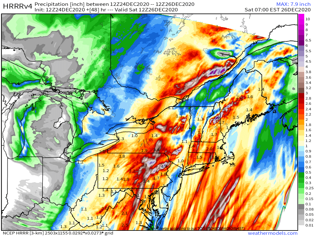
A second unusual aspect of this event is the very high snowpack in place across much of the interior northeast. A swath from central PA to Binghamton to Saratoga to Concord to Portland picked up 2-4 feet of snow just last week, and much of that snow is still on the ground. This snowpack holds 1-3″ of liquid water. Surrounding areas have less snow, but 0.5″-1.5″ is still common in almost the entire northeast. As rain falls on this snowpack, quick to rapid melt is likely.
This all means that today’s storm, from the perspective of the rivers and the ground, is really like if today’s storm and last week’s storm, both very anomalous events, happened at the same time.
All of this liquid will be introduced to a ground that can support it to an extent. NOAA 6 hour FFG values, an estimation of how much liquid soils can absorb, are typically between 2″ and 4″ where the heaviest rain will be falling. But this tolerance will quickly run out for many, with a combination of snowmelt and heavy rain saturating the ground. As a result, where favorable topography overlaps with sufficient snowpack, flash flooding will be quite possible. The WPC even has much of the interior northeast under a moderate risk for flash flooding, which is very unusual, especially for December.
River flooding will also probably be an issue, with watersheds across the northeast seeing widespread rain and snowmelt. The NWS forecasts many rivers to approach or exceed flood stage, with some river offices forecasting the worst flooding since last year’s halloween storm or even the 2011 floods following Irene. Needless to say, if you live near a river, be sure to stay weather aware over the coming days!
To summarize, a significant moisture infusion unusual in its intensity and longevity will allow very heavy rain over parts of the northeast, especially where topographical convergence can persistently allow condensation. This rain will fall on top of a significant snowpack, which will introduce significant liquid to the ground. As a result, significant flash flooding and flooding are possible in parts of the interior northeast tonight into tomorrow morning.
Note: We won’t be blogging or tweeting during the holidays, but you can expect our next blog, with a NYE forecast, to be published on the 31st.
