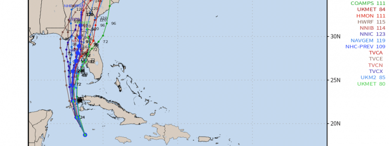
Hurricane Ian: Uncertainty and Impacts
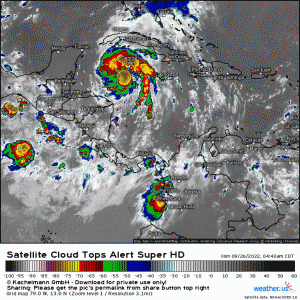
Ian is officially a hurricane this morning and, by the looks of it, may already be undergoing rapid intensification.
Sustained, deep convection denoted by the very cold cloud tops is consistently firing near the center. In addition, Ian has that “cocktail shrimp” look a TC displays when it’s preparing to rapidly intensify.
In the short term, Ian will impact the western end of Cuba with storm surge, wind, and heavy rain. It is possible that Ian could be a major hurricane at the time of landfall.
From there, once Ian crosses the relatively flat terrain of western Cuba, it will enter the Gulf of Mexico.
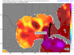
Ian’s projected path keeps it over parts of the Gulf with high heat potential – meaning there is plenty of fuel available to power the hurricane as it continues moving NNE’ward. This, combined with near-perfect atmospheric conditions, will allow the hurricane to maintain its strength or possibly intensify further. The official intensity forecast has Ian peaking as a category 4 hurricane while still offshore.
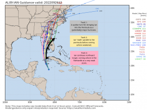
Some uncertainty remains as to Ian’s final track, mainly due to interaction with a trough and how deep the trough in question digs. However, if we look at this morning’s guidance, we can clearly see 3 possible outcomes.
Scenario 1:
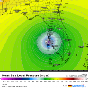
This cluster of tracks features a sharper, sooner northeast turn, bringing Ian into the peninsula between Tampa and Naples.
Currently, both the UKMet and the ICON favor this solution.
They both feature a less amplified trough that clears out more quickly, allowing high pressure to build in from the northwest. This would force Ian ashore before shear could do too much of a number on it. A landfall in this scenario could potentially be at major hurricane strength.
Impacts would be substantial surge, heavy rain, and strong winds, however, Ian would move inland quickly and weaken. Prolonged exposure to the elements wouldn’t be a factor.
Scenario #2
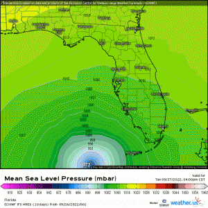
This scenario is the worst of the bunch and features a stalling hurricane just offshore.
The ECMWF favors this solution.
A slower-moving Ian treks northward as in scenario 1, but loses its steering when the trough over the NE US departs. As high pressure builds in, Ian effectively stalls just offshore of Florida’s densely populated west-central coast.
This, unfortunately, is a nightmare situation. While shear will act on Ian over time and weaken it, a (initially) major hurricane will sit in the perfect position just offshore and pump rain, wind, and life-threatening surge into Tampa Bay and surrounding areas.
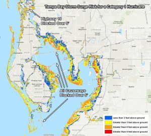
Dr. Jeff Masters posted this graphic last night. Keep in mind that this is tuned to a Category One hurricane. We may be dealing with a Category Three sitting offshore.
One thing that really stands out to me here is something I worried about constantly when I lived in St. Pete about 10 years ago: At 6 ft of surge, all escape routes out of Pinellas County are effectively underwater.
The current surge forecast for the Tampa Bay area is 5 to 8 ft (click here for graphic). Personally, if I were still in Pinellas County, I’d be planning to evacuate quickly.
Additionally, the bathymetry (shape/terrain of the ocean floor) of Florida’s west coast makes this a particularly worrisome scenario. The continental shelf slope is very gradual leading up to the coast. This would allow for an immense build-up of water if a TC approaches at just the right angle. Check out this tweet from Tim Ballisty for more info/resources on this topic.
Small shifts in track can increase the danger or lessen it, as we’ll see with scenario 3.
Scenario 3:
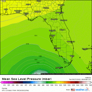
This scenario still features the stall like scenario two did, but it keeps Ian a bit further offshore for longer, resulting in a Big Bend/Panhandle landfall.
The GFS favors this solution. Though, its worth mentioning that the GFS has been correcting eastward over the last day or two.
If you’ll recall, I mentioned small shifts in track can make a difference in impacts. This solution features Ian stalling offshore like the ECMWF does, however, it is slightly more offshore than in the ECMWF run. While this is still a bad situation for Tampa and the surrounding cities, it might mean slightly less surge and slightly less wind.
The GFS goes on to continue taking Ian northward before bringing it ashore in the Panhandle/Big Bend. As shear would have more time to work on it, it would likely be a rather weak TC at landfall.
So, as we can see, impacts are all but guaranteed to Florida’s west coast. We now need to determine the finer points of the track to determine who is in line for the worst impacts.
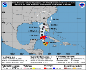
Here is the official NHC forecast. Adjustments in track will change impacts to an extent.
Florida’s west coast from the Keys to the Panhandle should be preparing for impacts right now. Impacts will, of course, vary with location. Check out your local NWS or local TV meteorologists for info more focused on your specific area.
In addition, those near the coast need to know your zone. Use that link to find out your evacuation zone and how much surge your location can handle. If you are in any doubt whatsoever as to whether or not you will be safe, get out anyway.
Lastly, keep in mind two things:
- Impacts will extend far from the center. Just because you are not right at the center doesn’t mean you can’t experience life-threatening impacts.
- Don’t focus on category only. The category tells you the wind speed. It does not tell you how dangerous the surge may be or how much freshwater flooding might occur. Look at the whole picture. Just because it may come ashore as a Category 1 doesn’t mean it’ll be a mild storm. Water, not wind, is the most dangerous component of a hurricane.
Stay tuned to our blog and twitter as we continue to track Ian and its impacts right along with you.


I’ve been looking for some analysis of the divergent forecast tracks for Ian. This is the best I’ve found. Thanks for putting this together and sharing it.
Well written and very informative. Thanks Meghan !!