How The January Pattern Is Similar to An El Nino
The pattern in the short term, as well on the horizon, is similar to that seen during El Nino’s. We’re, if you were not aware, in a La Nina pattern and certain patterns are grouped together and characterized by certain features (i.e. Southeast ridge, cool/wet Southwest, extended Pacific jets, etc). The pattern in the near-term resembles that of which we’d see in an El Nino, or at least one main component of it; i’m referring exactly to the Pacific jet, and then the pattern that follows thereafter as we head into mid-month.
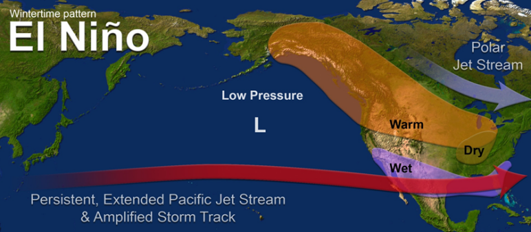
First, look at a composite created via NWS . They show a simplistic composite for typically what transpires during El Nino’s. While we can see dry Pacific NW and into the Plains, what stands out is the Pacific jet and how it extends across the Pacific Basin, leading to a lot of precipitation across the south. Now compare this to below’s information.
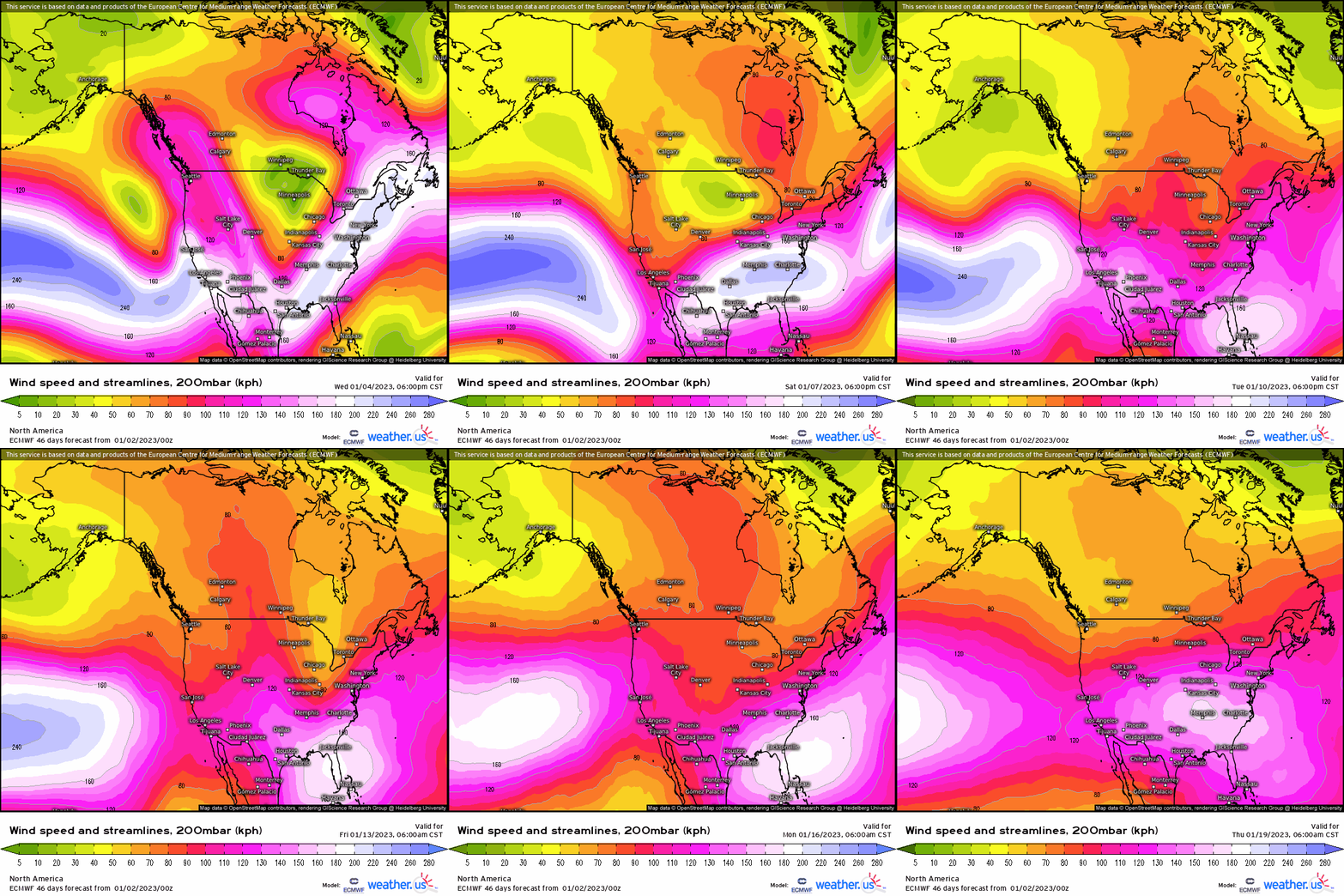
Second, lets look at a looped animation of the EPS 200mb wind, denoting the jet stream level. You’ll two main things; initially at first, it’s highly energetic and the higher wind speeds indicated by the bright purple and pinks, are basically extended into the West Coast. I discussed the implication of this, or atmospheric river, in my most recent blog. We tend to see the Pacific jet extended like this during an El Nino (hence the above graphic), which delivers very beneficial precipitation out west. Then, you’ll notice by the end of the loop, there’s considerable easing and a retraction of the higher wind speeds and the jet itself.
Viewing this from now a mid-level, 500mb pattern progression and looking at several time periods. Over the next two weeks, we’re going to see a more Nino-type pattern and a change to the overall pattern itself across the U.S. First, as stated, as the Pacific retracts westward, this allows an Aleutian low to strengthen. So Pacific air still will try to work its way into the U.S. at times. Nonetheless, it’s this pull back that does initiate higher heights across the Pacific NW and into southern Canada.
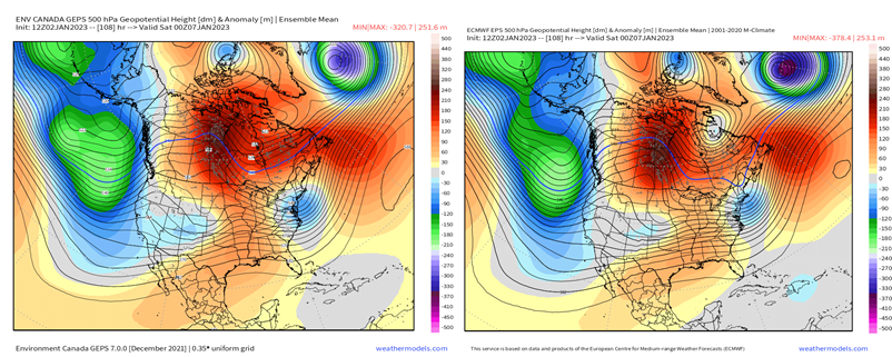
Fast forward next week, and we see that trough strengthen in magnitude and amplitude. In turn, this intensifies the ridging downstream and out across the Great Basin. What’s more, there are hints of a split-flow, where now the Pacific jet’s momentum is disseminated into the sub-tropical branch (notice the weak troughiness or dip in the contours across TX). A large ridge that paints itself across southern Canada is also characteristic of El Nino’s, with higher-than-normal pressure verbatim at the surface.
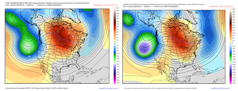
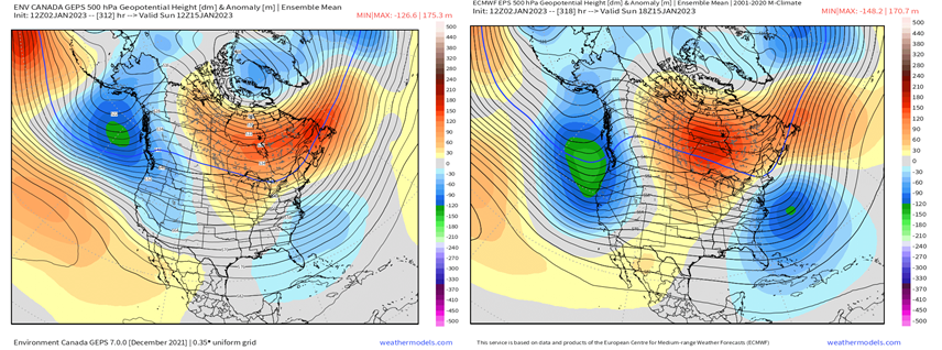
By mid-month, we get a modified “look” of below average heights nudging eastward and out in the Gulf of Alaska, with ridging across the Plains and southern Canada still, and an interesting look along the East Coast. This happens to be a timeframe that may need monitoring for a potential coastal system for the Mid-Atlantic and Northeast. When we see these pattern changes, and shift gears into January, this is typically where we see these strong nor’easters manifest. Regardless, this may harken a pattern change to more ridging west, and troughiness into the East. The latter, however, has low confidence.
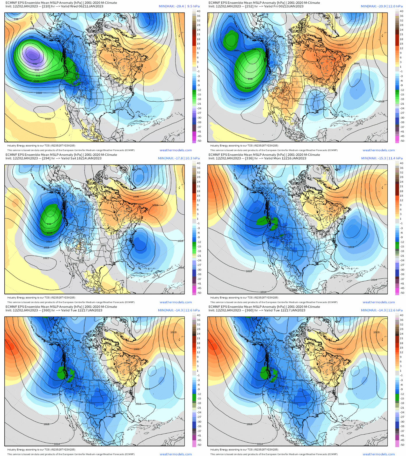
At the surface, it plays out as such: low pressure via the Pacific and sub-tropical jet keep an active wet pattern along the West before shifting into the South. Higher than normal pressure, from the above average heights shown at 500mb, stagnates across southern Canada. This may create an interesting scenario for the Eastern Seaboard as aforementioned, but we’ll cross that bridge once we get there. What holds later month certainly has very low confidence, as there may be a time-period where east of the Appalachian mountains turns cold & snowy and that would certainly benefit those regions as a large majority is currently dealing with below average snowfall.


Excellent article. I have been generating analogs of past weak La Nina years, but did not notice the current emerging similarity to an El Nino. It’s an intriguing comparison.
I also agree that those of us inhabiting the mid-Atlantic region may be entering a phase when coastal storms become more frequent. If the MJO remains in Phases 1 or 2 into February, we may be treated to the rare measurable snow event – although I would not lose any sleep if it never snowed here again.
Thanks again for your insightful article and best wishes on your continuing education in the field of long-range forecasting. I look forward to reading more of your materials.
Do you think that our current climate warming period has weakened the ENSO teleconnections?