Explosive Early Season Cyclone to Bring Dangerous Rain to West
A major coastal storm will strike the Pacific coast with a ferocity nearly unheard of for October, pounding the shore with high winds and bringing a substantial risk for dangerous debris flows. This blog will detail the unusual, dynamically loaded setup and the significant risk for dangerous rain-related impacts.
The set-up
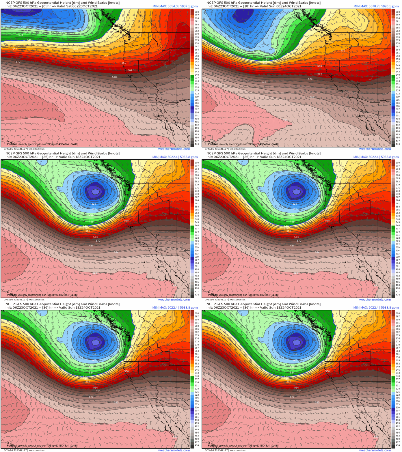
An extremely energetic Pacific jet stream already responsible for the intense storm system battering the Northwest will reload over the coming 24 hours, as a pivoting impulse amidst an Aleutian upper-level cyclone ignites intense divergence ~300 miles west of Oregon.
The rapid ‘spreading’ of air aloft will force huge amounts of mass to rise, coinciding with a dramatic lowering of pressure at the surface in the favorable lower-right sector of the upper level cyclone. In fact, the favorability of the governing upper-level cyclone’s development means the resulting rate of surface pressure deepening will be unusually explosive.
Meteorologists have a term for such runaway intensification: ‘bomb cyclogenesis’, in which an extratropical low (like this one) intensifies by 24mb in 24hrs. There’s a reason the concept of a ‘bomb cyclone’ has been sensationalized by the media; an overwhelming majority of the most intense wintertime storms have featured such rapid pressure drops, from infamous blizzards to dramatic cool-season tornado outbreaks to prolific atmospheric river events.
This makes sense, given the atmospheric truth that deeper low pressure centers are associated with stronger pressure gradients, which are associated with more rapid airmass movement (advection), more intense frontal uplift (convergence), and more substantial wind (wind).
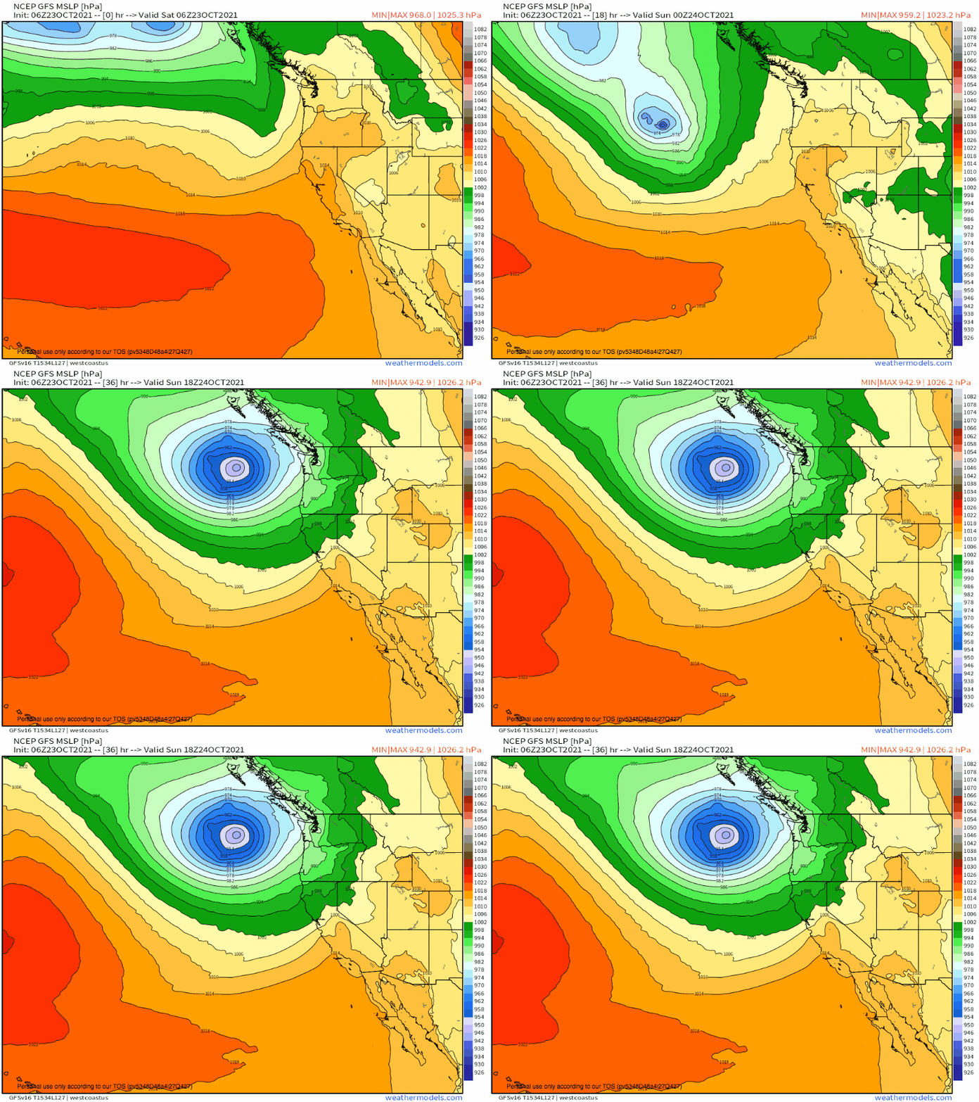
All of this to say that the low pressure system developing over the northwest Pacific is modeled to intensify by an astonishing forty seven millibars in 24 hours. That’s about double the rate required for a cyclone to be deemed a ‘bomb’, and it rivals the most impressive rates of deepening ever observed.
Such intensification will also jig the zone of unusually strong frontal lift (remember, a feature of strong lows!) in such a way that it moves much more W->E than S->N: almost parallel to its coast-perpendicular orientation. This can be seen in the isobaric kinks sliding south of the intensifying low.
This cold front, slow moving from the perspective of the ground, will provide the focal point for many of our impacts.
The rain
A few hundred feet above the surface, free of the limitations posed by stubborn friction, a lot of sensible weather is created. It happens as low level jets, so-called because of their near-surface altitude, carry airmasses across vast geographical regions.
A quick southwesterly low level jet, responding to the impressive pressure gradient associated with our bomb cyclone, will race east to the south of the aforementioned cold front. A conveyer belt for the atmosphere of its source, this LLJ will enthusiastically carry warm, moist central-Pacific air with it. The result will be a belt of vigorous moisture advection, an atmospheric river, if you will.
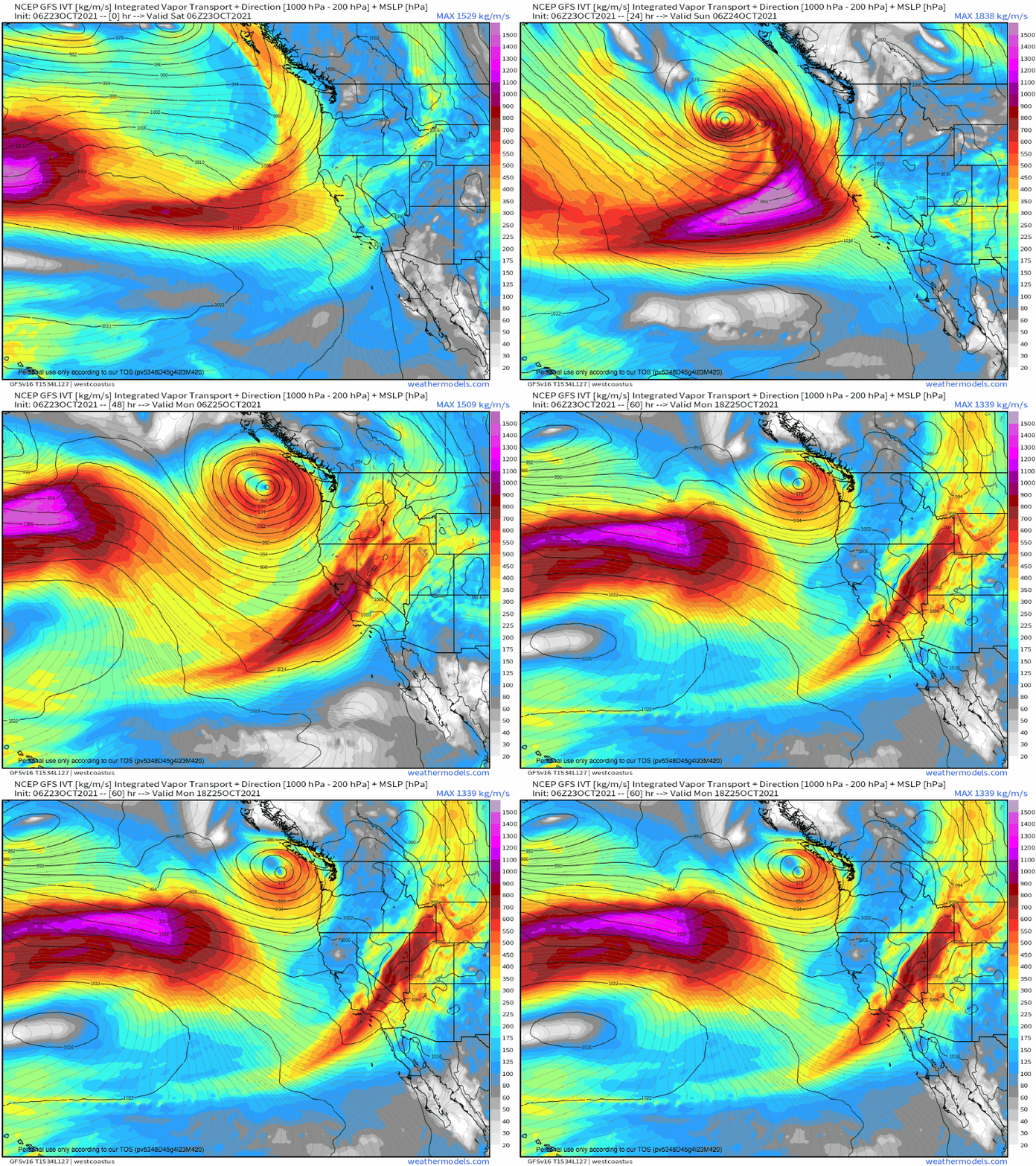
A parameter called integrated vapor transport shows the intensity with which moisture is advected. Looping this parameter over the northeast Pacific shows two things:
- The region of moisture transport associated with this weekend’s storm is remarkably robust, featuring deep moisture and intense transportation.
- The tongue of enhanced vapor advection is defined as a band of intense southwesterly flow just south of the cold front. As the cold front moves only slowly N->S, so too does the band of elevated IVT. As a result, some parts of California will see an incredible duration of very intense moisture advection.
Moisture advection alone does not a rainstorm make; something needs to lift all those sopping parcels until they cool enough to condense. But it isn’t hard to get lift in coastal California, especially not when a dramatically intense surface low is involved.
The ascent necessary to turn moisture to rain will come from two places this weekend.
- Topography, which will force air to ‘pile up’ and rise. This will be focused in two places: along the coast, where increased friction will lead to convergence; and the hills and mountains of California, which will physically block air and force it to ascend orographically.
- Along the cold front, where surface wind will converge and be forced to rise.
Success at forcing ascent is a function of immobility and intensity of convergence. So, most capable of turning moisture into rain will be mountains, which don’t move but inspire extreme convergence. This is followed by coastal friction and the cold front respectively, as the former does not waver but also inspires less intense convergence; while the latter moves, albeit slowly, and is fairly narrow. That being said, where the cold front does end up, a narrow band of strongly forced showers will pile up rain at a rapid rate.
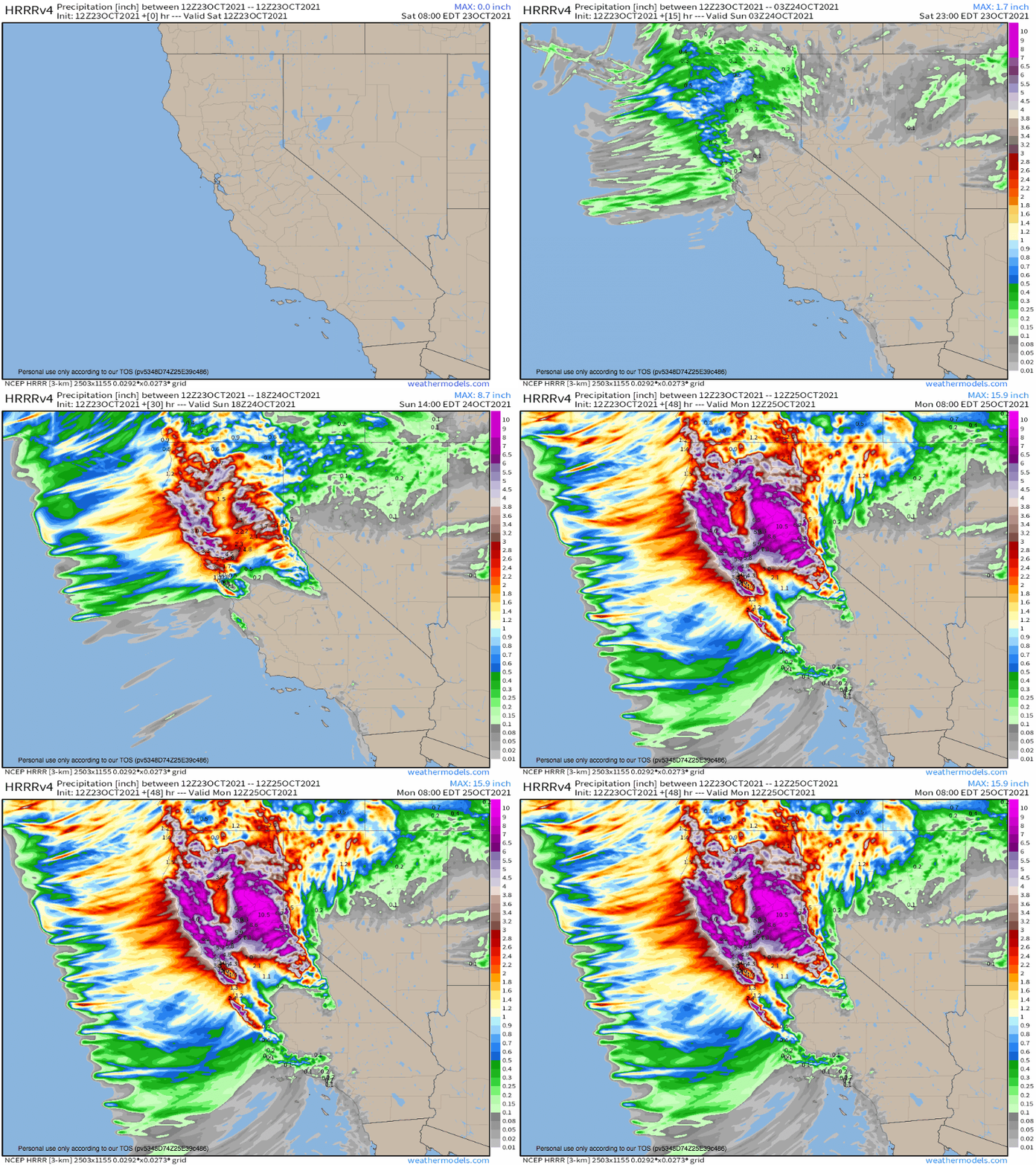
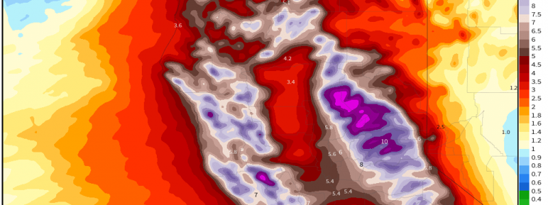
The combination of subtle frictional forcing for ascent, dramatic but narrow cold-frontal forcing, and long-fused, dramatic orographic lift will promote a dangerous environment in which more than 10″ of rain are locally plausible amidst rain that, at times, could fall with rates exceeding 1″/hr.
California is not facing this atmospheric river in isolation. The deluge of rain falls after two of the worst wildfire seasons on record impacted the state back-to-back. The result is a patchwork of burn scars, with soil rendered hydrophobic by ash and unanchored by decimated forests. Concern is especially large in the vicinity of the fresh, expansive Dixie fire, which smashed the record for largest single fire while growing to almost 1,000,000 acres in size. In this huge zone of hydrophobic, unstable soil that’s partially focused along steep hillsides and mountainous terrain, disastrous debris flow could very possibly occur as extreme, long-lasting moisture transport interact with immobile topographic forcing. If a line of slow moving, strongly forced cold frontal storms move through, it could help instigate such flows, though it’s possible they occur spontaneously due to more subtle but longer-fused rainfall.
If you live near steep slopes and/or burn scars, now is the time to contemplate how you will evacuate if need be. Have a kit ready. Never sleep without a WEA-equipped phone or NOAA weather radio. This could be, locally, very dangerous.
