Eta, Threat to Cuba and Florida, Intensifies
Well, it’s happening again. It’s November 7th, 2020, and another storm is quickly (perhaps rapidly) intensifying on approach to landfall.
Eta was at a relatively unfavorable base state for considerable intensification when it emerged from the northern Honduras coast yesterday. The storm was extremely disorganized, lacking any semblance of convection near its center of circulation. Additionally, Eta was moving through an environment characterized by relatively large shear, with vectors pointing towards the northeast. This threatened to keep the storm too vertically tilted for significant intensification before landfall, and also threatened to advect dry air to the west into the storm’s circulation.
But in spite of all of that, Eta has once again begun to quickly organize, taking advantage of warm SSTs and perhaps favorable venting from a jet to the storm’s northeast, deepening to a mid-range tropical storm with 50 mph winds.
Here is a diagram about these two different types of jet influence on Eta. I expected the flow related to the Gulf trough to keep Eta disorganized, despite favorably oriented venting flow allowing convective intensification. Evidently, I over-emphasized the impacts of the unfavorable shear.
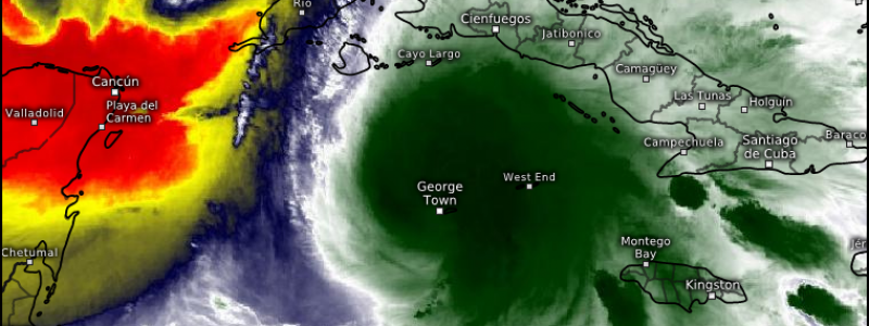
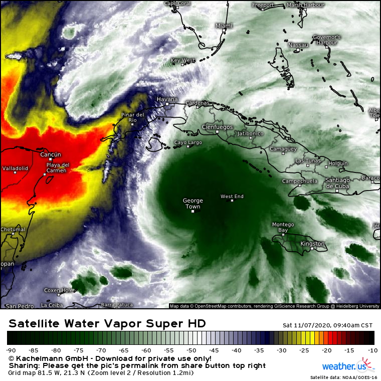
This water vapor imagery shows a bunch of what’s going on. There is the shrimp-like Eta, which has cocooned itself into an envelope of relatively moist air surrounding its CDO. This degree of organization then provides a buffer against unfavorable shear, and against the dry air that shear may advect into the storm’s circulation, seen to the northwest. To the northeast, meanwhile, the upper level flow can be seen by the moisture it wicks away from the circulation. Speed increases with distance from Eta in this jet, meaning speed divergence can help deepen convection and thus, Eta, today.
Runaway intensification to anything stronger than a category one hurricane is still unlikely in the short term, though. Eta is a tropical storm, and only around 18 hours from landfall. While it’s in a parameter space that favors intensification of an already organized storm (warm SSTs, organization, a good relationship with shear for the time being, favorable outflow, a moist envelope), it’s too marginal for the type of rapid intensification we saw with Eta earlier this week.
So what’s next for the storm?
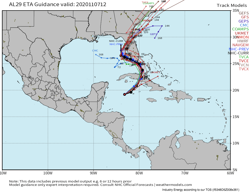
Tight model consensus has developed in the short to medium term. For those who read my last blog, there were some questions about where exactly the steering currents would shift from north of east to west of north, allowing the storm to curve sharply left towards the Gulf of Mexico. At this point, though, it’s clear that the storm will likely be impacted by the Gulf trough’s northwesterly steering near the Bahamas, allowing Eta to clear Cuba before curving towards Florida, moving through the Florida Keys or southern Florida, and then likely recurving to make landfall somewhere north of Tampa.
The whole time, the storm will be moving slowly, as steering is passed between the outer fringes of several weak, slow-moving features and as Eta finally coalesces with a slow upper level low. Because of Eta’s slow, looping, coast-parallel path, there’s a real risk for the type of persistent heavy rain in Florida that could lead to widespread flooding.
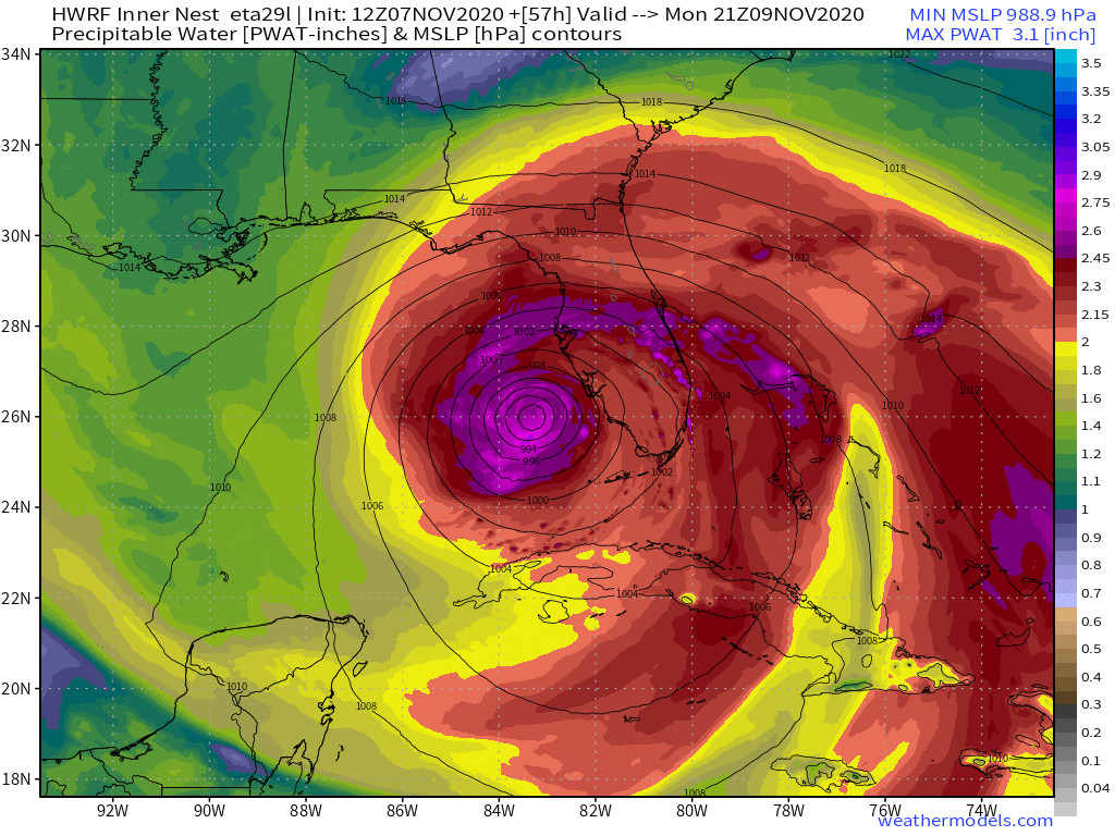
The latest HWRF precipitable water plot shows how this risk could play out. While Eta meanders just off the southwestern coast of Florida, the model projects intense moisture advection, with PWATs locally exceeding 2.5″(!) in feeder bands arching through the entire Florida peninsula towards the center of circulation. As these feeder bands will also feature a great deal of atmospheric convergence, and as the position of this convergence and deep moist advection will be fairly persistent for as long as Eta moves slowly, there is a real risk for serious flash flooding in parts of Florida from Sunday through Tuesday.
Link: https://lab.weathermodels.com/models/hwrf/hwrf.php
This is in addition to rain directly related to convergence and lift at Eta’s center of circulation, which will probably impact a fair amount of Florida’s coast.
As a result, the global models depict some hefty rainfall totals in parts of the state over the next five days. 
Now, this map shouldn’t be taken as an actual point forecast for a specific location. Rather, it demonstrates the potential for widespread 3-6″ of rain, with a few points impacted by either feeder bands or the slow-moving CDO seeing significantly more.
Of course, there will also be wind and surge considerations from Eta. These will be much more dependent on intensification post-Cuba than freshwater flooding from rain, so we don’t know a whole lot yet. However, we can make some educated guesses. In all likelihood, Eta will be a strong tropical storm or weak hurricane with a fairly disorganized structure after crossing the island nation. At this point, the storm will likely either plateau in intensity or strengthen a tiny bit more before beginning to take in some dry air, as moderate to strong shear likely holds off re-organization post-Cuba. As this happens, Eta will slowly weaken, and it doesn’t look like a hurricane-strength landfall should be likely in Florida. Correspondingly, the storm surge threat shouldn’t be too significant, with likely inundations to ~3 feet per the NHC.
Eta is a resilient storm, and is currently restrengthening to a moderately intense tropical storm despite a fairly poor environment. It will landfall in Cuba as a high-end tropical storm or low-end hurricane late tonight before slowing down and meandering near Florida for a few days, bringing heavy rain to much of the state along convergent feeder bands as well as the storm’s center of circulation. Stay tuned to our twitter and this blog for more on Eta, and keep tuned to the NHC if you live in Florida for official advice.


