Eta, Now a Hurricane, Approaching Landfall North of Tampa
Eta has strengthened to a category 1 hurricane, with winds of 75 mph. Gusty squalls are already impacting W. Florida, including Tampa, with heavy rain, gusty winds to tropical storm force, and isolated tornadoes. As bands from Eta push ashore today ahead of the approaching hurricane, storm surge is building in places, including the Tampa bay. The storm is expected to landfall early tomorrow near Citrus Springs, Florida, impacting the coast near landfall with high end tropical storm force winds and 2-3 feet of storm surge, and pushing 3-5 feet of dangerous surge into Tampa bay.
Link: https://weather.us/satellite/florida/top-alert-superhd-15min/20201111-1530z.html
Eta intensified a fair bit overnight into a category 1 hurricane, with 75mph sustained winds. Since then, the satellite presentation has degraded considerably, and deep convection has effectively totally collapsed. In all likelihood, Eta will weaken to some degree before landfall, as it increasingly feels the impacts of shear and dry air without any meaningful deep convection.
For many in Eta’s path, this changes very little: impacts will be mainly related to wind in the convergent feeder bands and the storm surge already being pushed ahead of the storm.
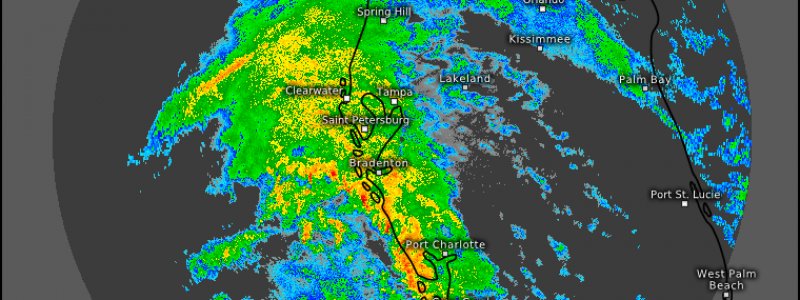
Many of the impacts associated with Eta are already occurring, as a powerful convergent band rotates onshore from Naples to Tampa. Winds with these bands are gusting to tropical storm force, and even stronger, more damaging gusts are possible in any convection. All of this will coincide with heavy rain.
Link: https://weather.us/radar-us/830-w-268-n/reflectivity/KTBW_20201111-160545z.html
Of note are the little red notches on radar, most visible in an arc just off the shore from Bradenton to Cape Coral. These are convective cells. Where these cells move, convective momentum transfer of winds well above the ground is likely, a process that could lead to locally damaging gusts.
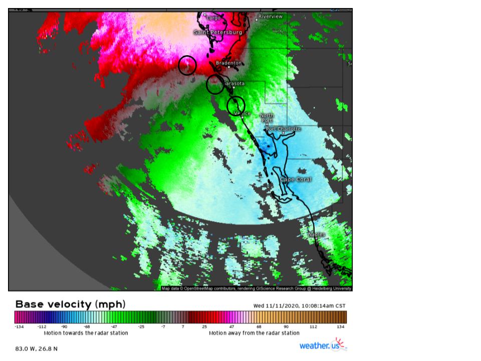
Zooming in with velocity imagery reveals that many of these convective cells could be packing another dangerous threat: rotation that could lead to isolated tornadoes.
Link: https://weather.us/radar-us/830-w-268-n/velocity/KTBW_20201111-160814z.html
I’ve circled some areas where there appears to be rotation as I write this, but these types of mesocyclones are prone to quickly develop and wind down. For residents of the central west Florida coast- be prepared for a potential tornado! Monitor NWS alerts and have more than one way to receive a warning.
The threat for heavy rain, gusty winds to strong tropical storm intensity, and damaging wind gusts/isolated tornadoes with convection will shift north along the west Florida coast through tonight.
The other major threat with Eta will be storm surge. The storm has been over water for a while, and water within the circulation is The favorable shape of Tampa Bay will lead to inundations of 3-5 feet, which is potentially life threatening for those who do not heed local advice. Remember: when approaching flood waters in a car, turn around, don’t drown!
Similar inundations are likely across other parts of the central Florida coast, and Cape Coral should expect 2-4 foot inundations, which once again could prove dangerous.
Eta will batter much of the west coast of Florida with a potentially significant storm surge, heavy rain, winds to tropical storm force, and convection capable of isolated tornadoes and damaging wind gusts. Those in the areas impacted should be sure to heed the advice of local officials and the NHC. Eta may not be a significant hurricane, but significant impacts are still possible along its path.


