Eta, Close to Landfall, Brings Potentially Catastrophic Flood Threat to Nicaragua, Honduras
A dire situation is shaping up for Nicaragua and Honduras over the next few days as hurricane Eta meanders slowly inland, dropping extreme rainfall and likely leaving behind significant floods and mudslides.
…
Eta dramatically organized yesterday afternoon, developing a pinhole eye and a fierce ring of -85°C cloud tops more reminiscent of a super typhoon in the Western Pacific than an Atlantic hurricane. Recon last night found winds and pressures representative of a strong category four hurricane; 923 mb and 150mph. I’ve attached a satellite loop from last night; the storm was one of the most well-organized I’ve ever seen in the Atlantic, especially for November.
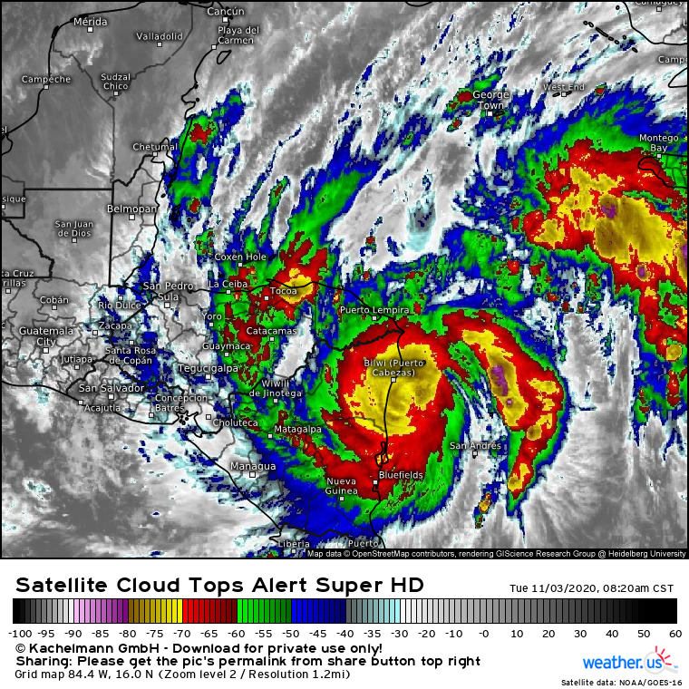
The storm has since undergone an eyewall replacement cycle, crushing the small eye. According to the hurricane center, Eta is now a 145mph category four, with a central pressure of 936mb. This is what the storm looks like now:
Clearly, the storm has lost some organization, and winds are a tiny bit weaker than last night. This hardly makes a difference to what will likely be catastrophic, life threatening impacts from Eta.
Eta is moving very slowly just offshore, and the CDO is currently battering much of coastal Nicaragua with tropical storm force winds and heavy rain. Where the center moves ashore, major hurricane winds will cause catastrophic damage to structures and infrastructure. Near the landfall location, a dangerous surge of 14-21 feet above tide level is likely. Both of these threats will almost certainly be locally devastating, and could prove very deadly.
The most catastrophic impacts from Eta will be a longer fused onslaught of heavy rain that has already begun and is likely to last through the next few days.
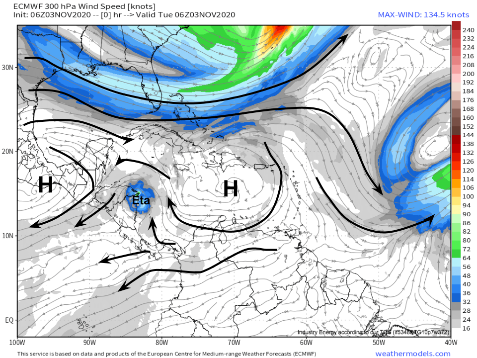
As the hurricane approaches landfall, steering currents have all but collapsed. Caught in a ‘gap’ between two weak ridge lobes, Eta has very little incentive to move today.
This is a pretty classic hurricane stall process, and it shows in how little forward movement Eta has managed: over the last 12 hours, the storm has moved less than 50 miles!
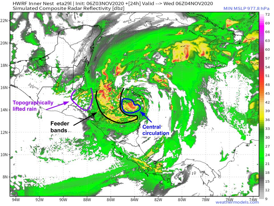
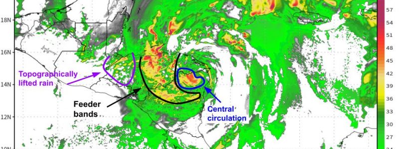
From here on out, the significant rain event over central America will feature two distinct ‘regimes’ as the slow moving storm, well, moves slowly:
- Atmospheric lifting: persistent heavy rain near the slow-moving center of circulation and along convergent feeder bands
- Topographical lifting, as persistent very moist flow condenses via upslope lifting.
The first is already occurring, as the central dense overcast has been able to batter basically the same parts of the Nicaragua coast for the entirety of the last 12 hours with heavy rain. It is likely that significant flooding is already happening, or is imminent, for portions of this region. As the hurricane makes landfall, this flooding regime will continue at all elevations both near the immediate circulation and near any persistent feeder bands. This is how most flooding from US hurricanes happens- the circulations and feeder bands of slow-moving systems feature powerful convergence and lift capable of turning the deep moist flow inherent within a tropical system into an extreme deluge.
The second also may already be occurring, as very moist onshore flow in the lower levels, advected inland by the storm’s circulation, hits the rough, mountainous terrain of Central America and is lifted into rain. Because mountains don’t move, this type of topographically influenced rain can be extremely persistent, dropping efficient rain for as long as onshore flow stays constant. With a slow moving hurricane like Eta, that could be several days. This type of flooding regime could be very dangerous, as complex terrain favors potentially devastating impacts from heavy rain, such as mudslides and secondary flash flood.
I’ve annotated this HWRF modeled radar image for hr24 with these two precipitation regimes.
As Eta shifts north into northern Central America and Mexico, heavy rain looks to follow, as the same flooding mechanisms I’ve discussed shift into new areas.
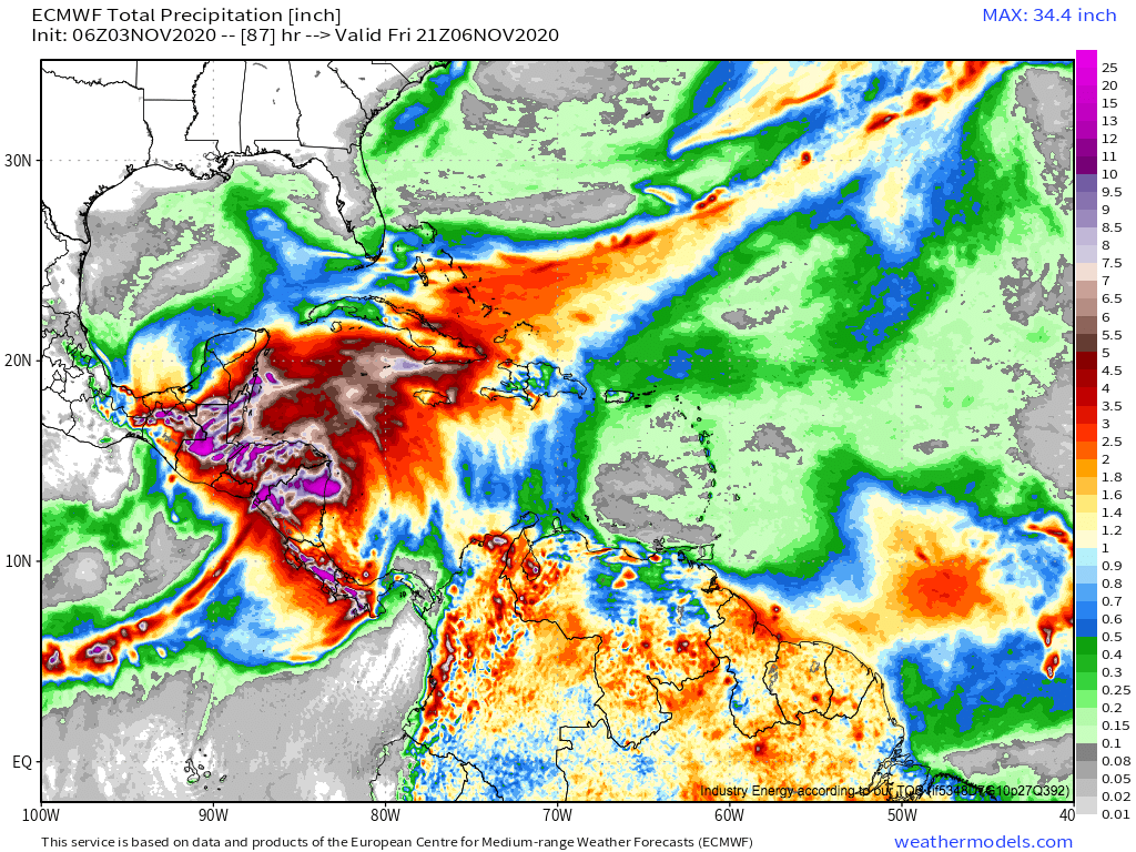
Clearly, there are a lot of mechanisms by which heavy rain will be likely, centered initially over Nicaragua and Honduras. As long as the hurricane continues to move slowly, these flooding regimes will persist. Because Eta looks to stick around until Friday morning, extreme rain is likely, and global models continue to project rainfall totals in the 10-30″+ range for a relatively large area through the end of the work week.
Flash flooding is devastating anywhere, but a combination of social and topographical factors make Central America particularly vulnerable, at least historically. Some of the most devastating, deadly hurricanes in Atlantic history were those that allowed persistent flooding in Central America, especially in the mountainous regions where mudslides can tragically wipe out entire villages. Examples of such storms include Stan, Mitch, and Fifi, which dropped similar rainfall totals to Eta’s forecasts in central America and were responsible for thousands of deaths. Hopefully this kind of tragedy is not repeated this week, but it is certainly possible.
Hurricane Eta will make landfall soon, bringing a threat for extremely destructive winds and storm surge where the center moves ashore. In the days to follow, the storm will produce catastrophic flooding over much of Central America with a potentially tragic combination of topographic and atmospheric lifting.
We will keep you posted here and on twitter, and I implore anybody in impacted regions to monitor local governmental statements and the NHC. Eta will likely prove a devastating storm.

