Entering a Very Active Pattern: Saturday’s Dual Ice and Severe Threats
You’ve undoubtedly heard us mention at some point this week that the pattern has been active. That’s true, however, hang on to your hats because it’s about to crank up from active to widely impactful. We have a veritable conga line of disturbances waiting to cause problems across the US. Combine that with some seriously cold air and we get widespread impacts. This winter has obviously decided it wants to give the 2020 hurricane season a run for it’s money on memorability.
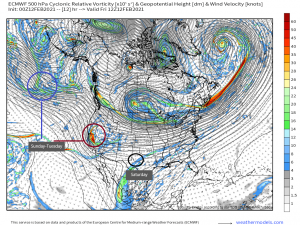
So here’s what we’re looking at. One small disturbance, or shortwave, and then a larger, multi-day, multi-wave storm. Honestly, due to how close together these will be, it’s going to be kind of hard to distinguish between individual “storms.” It begins slowly on Saturday and then cranks up in intensity and impacts as we progress through the weekend into early next week until all of the energy finally exits some time on Tuesday. All modes of precip will be seen with these storms due to the set up currently in place over the US.
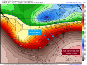
We already know that, to our north, we have a ball of cold, dense, arctic air that is just slowly sinking southward, chilling the northern Plains states. That will surge further south this weekend, bringing well-below average temperatures likely all the way down to the Texas and Louisiana Gulf coasts. Jacob wrote about this set up in his blog yesterday, so I’m not going to rehash that part. However, in opposition to the trough of frigid air, we have a ridge of high pressure to our south that is doing a few things for us.
- It is blocking the Arctic air from filtering into the southeast (bless you, southeast ridge!).
- The boundary between the ridge and the trough is basically providing a pathway for disturbances. As long as this set up holds, storms will follow this dip and crest path: dipping down to the Gulf, pulling moisture from it, and bringing it into the northeast.
- Warm, moist air under the ridge is being advected northward over top of the colder, denser air at the surface. So, near this boundary between air masses, we encounter the problem of warm air aloft and shallow cold air at the surface. We can infer from events earlier this week that this sort of set up indicates the potential for freezing rain and ice accretion, and likely over a long, but narrow, area.
We will likely have several chances at freezing rain and icing issues over the next 5 days or so, but due to the very specific conditions required for this to occur, different areas will have different potential from day to day. We’re going to look at this on a day by day basis in order to give full attention to the variety of threats each day will bring. So, this blog will cover Saturday’s threats.
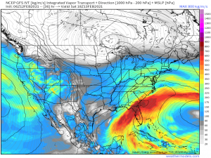
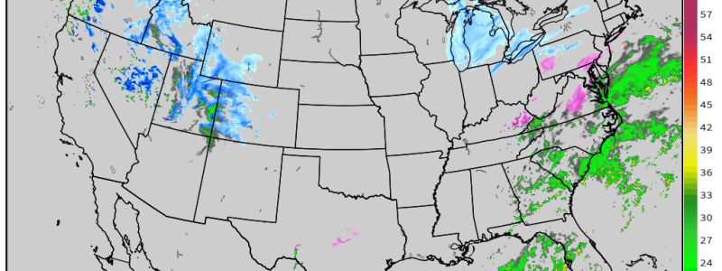
Saturday looks to be the quietest day of the next five as far as widespread effects go. A small disturbance will pull moisture from the Gulf and slide it up through the southeast, mid-Atlantic, and, to a lesser degree, the northeast. While this will be all rain for the southeast, a large part of the mid-Atlantic has the potential for freezing rain.
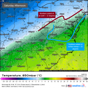
The moisture will spread northward through the day Saturday, reaching the mid-Atlantic by the latter half of the afternoon. At this time, everything from roughly the North Carolina border north is expected to be sub-freezing while the warm air aloft is expected to advect as far north as perhaps New York City. It is here we will see the biggest threat for ice accretion. Understand: these are not hard and fast borders. As I’ve explained before, literally one degree either aloft or at the surface could change the mode of precipitation an area sees. It could be raining and 33 degrees at your house with no ice forming but if your sister’s house 2 miles away is 31 degrees with rain, that rain is freezing on elevated surfaces. Very specific conditions.
As far as the mid-Atlantic is concerned, there isn’t a ton of moisture associated with this weak disturbance, but don’t let that lull you into a false sense of security. It only takes a thin glaze of ice to make for treacherous conditions. If you’re in the defined ice risk area, or even near by, make plans to stay home beginning tomorrow afternoon. As we’ve seen already this week, though you can drive in snow, no one is guaranteed to be able to drive even remotely well in ice.
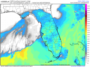
Direct your attention, if you would, back to the map we just looked at. Notice the deep red shade of abundant moisture over Florida? Warm, rising air plus abundant moisture equals….? Yep, you guessed it. On top of tracking ice, snow, and absolutely frigid temperatures, we have a severe threat materializing for Central Florida tomorrow.
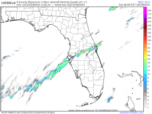
A stationary front draped across northern Florida will likely preclude that part of the state from any severe weather tomorrow as it sits in rain-cooled air from early day shower activity. However, below the front in the warm sector, destabilization is expected to occur as temperatures surge into the 80s while dew points climb near or into the 70s. Shear, though stronger further north, is expected to be adequate to support the formation of a few strong storms near the boundary between the warm and cool sectors. Inland central Florida could also see the formation of severe storms due to the convergence between sea breezes off the Gulf and off the Atlantic. Lack-luster lapse rates and lesser shear means that the primary risk with these storms is damaging winds but a brief tornado can’t be ruled out. We’ve seen marginal set-ups produce somewhat significant, short-lived tornadoes already this year, so never count that out.
With at least a few decent helicity swaths showing on the HRRR, it’s worth keeping the possibility of a low-end tornado threat in mind. As on any day with even a small severe risk, remain weather aware and have multiple ways to receive warnings should they be needed.
So our “quiet” Saturday turns out to be not so quiet after all, though it will still likely be the least busy, weather wise, of the next 5 days. Those along the boundary line between sub-freezing air and warmer air facing an ice threat in the coming days, use today and tomorrow to prepare. Get your groceries and errands done so you do not have to risk your life to travel should the ice accumulate in your area. Have batteries, flashlights, and candles in case the power goes out. Have gas for your generator if you have one and make sure it’s installed safely!!! Most importantly: have a way to stay warm if the power goes out. Whether that means having extra blankets, sweaters, a heater… whatever. Temperatures will only get colder as the weekend progresses so be sure to be prepared for the cold in case the power goes out and stays out.
Jacob and I will be blogging all weekend keeping y’all up to date with the developing situations and associated threats so check back here daily to see what’s up! Have a great day!
