Destructive Severe Storms Take Aim at North-Central US
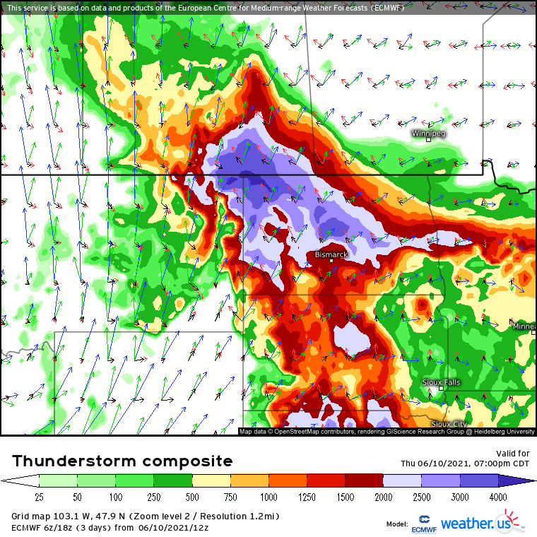
A significant round of thunderstorms capable of producing highly damaging winds, large to giant hail, and scattered tornadoes will be possible across the northern Plains this evening.
A synoptic-scale environment supportive of severe thunderstorms has developed across the CONUS. While broad ridging dominates much of the southern and eastern parts of the country, a compact but intense midlevel trough is pivoting northeast from the Great Basin towards the Canadian border today, imbedded within a broad belt of 40-70 kn flow.
Downstream of the ejecting trough, fairly rapid height falls for this time of year are siphoning a great deal of air vertically upwards, which is promoting the development of a fairly deep but still somewhat diffuse low-level cyclone currently centered over west Montana. Associated pressure falls will continue today as the depression increases in both organization and intensity, continuing an advection regime characterized by high-end Gulf moisture and hot temperatures. In fact, a broad corridor of the northern Plains is currently seeing temperatures exceeding 90ºF and dewpoints approaching, or even exceeding, 70ºF.
This is a combination of heat and moisture not commonly seen in such proximity to such an intense midlevel impulse, and the result will be an unusual overlap of moderate bulk shear over very strong instability, amidst minimal convective inhibition. This is an environment primed for significant severe thunderstorms, as updrafts explode upwards and are organized into long-lived storms.
With the aforementioned seasonally impressive low-level cyclone, the next question may be whether these explosive storms, which are already initiating as I write this, can rotate enough amidst brisk 850mb flow to drop strong tornadoes. The answer is, sort of. While initial cells could certainly produce a tornado, or even a significant one in the vicinity of the warm front over ND, the incredibly supportive parameter space sans inhibition will probably guarantee the type of rapid upscale growth that will limit the tornado threat after the brief window of opportunity. But this also means that when the tornado threat ends, the severe thunderstorm threat will be only beginning.
Hail will be the first threat to maximize amidst the quickly linear-izing supercells, amidst fat CAPE profiles and fanning shear. Swaths of large hail are effectively guaranteed; a giant stone to 4″ is possible where instability and storm mode collaborate. The timing of this threat will make it most volatile near the ND/SD/MT border region.
As the storms move east, deeper into the Dakotas, they will probably develop a series of organized cold pools, capable of driving the entire coalesced band of storms into a large series of bow echoes that will almost look like one giant thunderstorm.
The result could be an expansive series of swaths of damaging wind, with a number of hurricane force wind gusts imbedded. Derecho characterization certainly looks like a strong possibility as the storms cover hundreds of square miles with severe wind gusts. Those from the Dakotas east to western Iowa and Minnesota and south to southern Nebraska are implored to sleep with ringers on tonight, in case a severe thunderstorm warning for high-end damaging wind triggers local WEAs.


