Consensus Building for Significant New England Coastal Low
A quickly intensifying surface low will likely bring heavy snow, rain, and wind to New England this weekend.
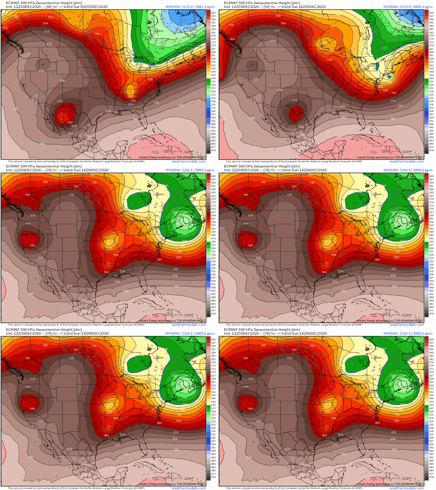
First, a meteorological background to our system. An intense, strongly positively tilted southern stream closed trough that was recently responsible for heavy Oklahoma snow and, to an extent, the wildfires in California will phase with a high-amplitude northern stream impulse swinging down from Canada this weekend. As the phased systems close off into a deep midlevel low over Western New England, a significant snowstorm will likely occur over parts of the interior northeast Saturday into Sunday.
As with every snow storm, there are a few important pieces to consider when forecasting for this weekend. These concern:
- The system’s dynamics: precipitation production
- The thermal profile: precipitation type and snowfall ratios
Each aspect of forecasting a winter storm carries its own contributions to both the final impact forecast and the uncertainty assessment. So let’s get to it!
Like with any precipitation event, there are a few ingredients needed to get heavy precipitation in a nor’easter. The first important one is moisture.
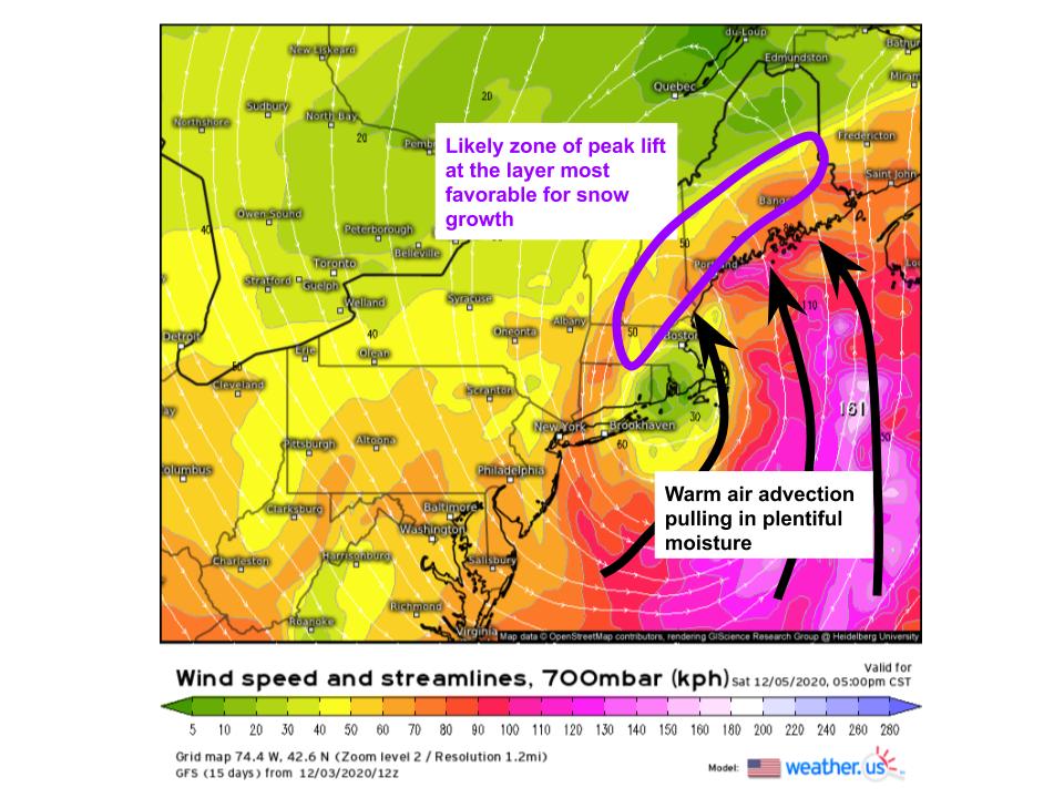
The fact that the impulse responsible for our storm is a southern stream native bodes well for moisture, as it means there’s likely an open channel by which high-precipitable water air from the subtropical Atlantic can advect into the storm’s circulation. A look at PWAT as modeled by the Euro confirms this hunch: significant warm sector advection of high precipitable water will mean even the cold sector, close to the low, will see sufficient moisture for moderate to heavy precipitation.
Now, this is where we introduce the first forecast uncertainty. As usual, the cold sector of our storm will see a significant gradient of moisture, as the southerly LLJ is increasingly removed. This means that heavy precipitation chances will drop off considerably with distance from the cyclone and attendant modified coastal warm front. If the low is too far east, then, there won’t be sufficient moisture for heavy precipitation.
The next consideration is lift. Unlike in the warm sector of an atmospheric river, it isn’t hard to find sufficient surface convergence for precipitation to the north/northwest of a surface low, with relatively large-scale surface based lift along first coastal fronts and then the low itself, and any related surface troughing. These concerns about whether or not lifting is present at all are replaced, then, with concerns about how persistent lifting will be, and where it will overlap vertically with favorable snow growth.
A simplistic but often reasonably accurate way to deduce where the lift most favorable for heavy snow will set up is to look for bands of 700mb frontogenesis, or areas where the direction/speed of flow changes in a way that allows thermal gradients to grow or shrink. Frontogenesis promotes lift, and 700mb is where the most favorable zone for snow growth can generally be found, so this makes sense.
Wherever the band of 700mb frontogenesis can be most persistent, expect the highest totals of snow (at least given that temperatures support snow where it sets up!). The Euro currently has this zone of the most persistent, favorable lift stretching from interior S. New England to a stripe of central Maine. Naturally, this band’s location also depends on the track of the low, meaning it adds uncertainty depending on where the storm ends up.
There is also synoptic scale lift, which can enhance precipitation significantly if it is favorable. And boy, will it be favorable. Consensus has the northeast under the entrance region of a roaring jet streak, in a zone of very favorable divergence aloft, and to the northwest of a nearly 980mb low. Wow!
This all means that we have a good environment for precipitation to the low’s northwest, over much of New England, for heavy stratiform precipitation. There’s plentiful moisture, and good dynamic support for both a localized band of significant lifting, and more broad support for heavy precipitation.
Now, where will snow fall?
Currently, temperatures over much of the northeast aren’t all that cold. In fact, temperatures in the northeast are a fair bit above average today and tonight. There also likely won’t be much in the way of cold air reinforcement, with a Canadian surface high late to the scene. This means temperatures will certainly be an issue with the storm. Even still, some parts of New England, like the hilly interior, will have no trouble staying below freezing, should the storm remain off the coast. This is where the highest confidence currently exists for significant snowfall, where the support for precipitation I discussed before will most likely overlap with cold enough air for snow. For places like Connecticut (except the hillier/northernmost regions), eastern MA, and Rhode Island, antecedent temperatures are so far above freezing that most of the precipitation will fall as rain, basically no matter how the low tracks. The main shot at snow will be at the end of the storm, Saturday night, when cold air arrives in time for a few inches of snow to finish the show. Both of these are pretty straightforward forecasts. I-95 shouldn’t expect significant snow, while the hills of interior New England should. The forecast is trickier further north and closer to the coast, where temperatures will be aggressively marginal. This includes Portland, and a lot of real estate in coastal Maine, central Massachusetts, and northeast Connecticut. Here, there isn’t much I can say besides: it depends where the low ends up.
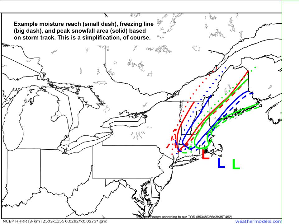
You’ve heard me say this a lot, by now. Everything from the amount of moisture that can overlap land, to the position of favorable lift banding, to the amount of precipitation that can fall as snow depends on where the dang low ends up. Consensus is higher than it has been, but still not high enough for New England meteorologists to sleep comfortably tonight.
Look at how much variability there is among the European ensemble set.
This means I don’t feel comfortable talking totals anywhere… yet.
But I will leave you with this map, which I believe adequately conveys what we do and do not know. Tomorrow, Meghan will fill in with any updates from the models. Until then, sleep with a spoon under your pillow (:


