Common Severe Weather Soundings Explained
With spring severe season in full swing, I’m going to take some time to explain a few of the more “common” types of soundings in regards to severe weather.
Soundings are a vertical snapshot of the atmosphere. Observed soundings are built from real-time data and are obtained by launching radiosondes (usually done by the NWS). Forecasted soundings are driven by model data and reflect what that model “sees” from surface to the upper levels.
Getting an idea of what is going on in each level of the atmosphere is very important in meteorology – but especially so when forecasting severe weather and winter weather.
Today, we’ll be using the weather.us observation database found here to obtain our soundings. Let’s take a look at some recognizable severe weather soundings.
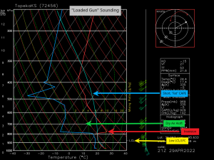
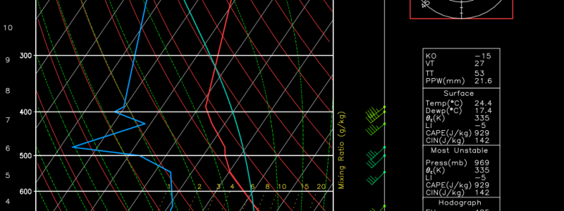
Loaded Gun
Characteristics:
- Low LCL and LFC – instability doesn’t have to travel far to be pulled into the cloud and begin rising. Can take full advantage of surface instability.
- Inversion (cap) – allows instability to build below the cap so that when it does break or erode, stronger, discrete cells are more likely.
- Dry air aloft – Dry air entraining into a storm leads to evaporation. Evaporative cooling enhances the hail threat.
- Short, “fat” CAPE – any rising parcel will be significantly warmer than the environment allowing for strong updrafts.
The Loaded Gun sounding is generally indicative of an atmosphere primed to put out significant severe weather. Damaging winds and hail are almost a given.
Tornadoes are possible as well if there is adequate low-level shear to support rotation. For tornadoes to occur, we typically want to see the wind veering (turning clockwise) with height as well as increasing in speed with height.
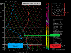
Wet Microburst
Characteristics:
- Steep lapse rates below the LCL.
- Substantial layer of dry air in the mid-levels – causes evaporative cooling and an increase in density. The suddenly more dense air then rushes to the surface with the heavy rain creating damaging winds. **Note: look at the wind speed in the layer of dry air. These are the speeds that will (approximately) be possible when pulled to the surface. Anything greater than 50 or 60 kts is a wind threat.
- High Precipitable Water values – leads to heavy rain and evaporative cooling in the dry layer as it falls through. Drives the wind threat.
The Wet Microburst sounding is very common in derecho environments.
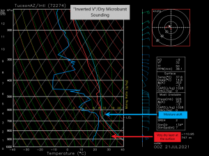
“Inverted V”/Dry Microburst
Characteristics:
- A very dry layer of air at the surface
- Moisture aloft – creates the upside-down V look of the sounding.
- Rain from aloft falls into the dry air, leading to evaporative cooling. The cooler, denser air then rushes to the surface, producing a wind threat.
This is a common sounding in the western desert environments. This type of environment also has the potential to start fires via lightning strike and then rapidly spread them as the air rushes to the surface.
Hope you learned something new today!
If anyone has any requests for future explainer blogs, please don’t hesitate to leave me a comment here or tweet it at me on Twitter.
