Christmas Eve 2020 Severe Threat
Well folks, it’s starting to look like Santa is going to need a tornado shelter instead of a sleigh in the Carolinas on Christmas Eve. The forecast is coming together to support a potentially dangerous situation tomorrow so it is on this we will focus in today’s blog.
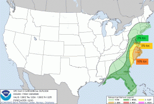
The SPC has, as of less than an hour ago, upgraded the risks for 12/24 to include an area of Enhanced risk over lowland North Carolina and SE Virginia complete with a 10% chance of a tornado. Let’s take a look at the set up before we get into the risks.
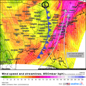
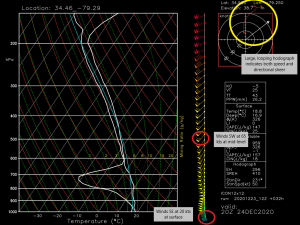
Ahead of the cold front set to bring frigid temperatures to the US, we have a very powerful southerly low level jet. By powerful I mean that winds at the 850 mb level (5000 ft) will be screaming through at 100+ knots (115+ mph). With speeds like this aloft, the wind speed from the ground up then changes rapidly with height, known as speed shear. Speed shear is an important ingredient in severe weather. It keeps the updraft portion of the storm separate from the downdraft, insuring that the storm can strengthen.
This jet will be pulling moisture and heat from both the Gulf and the Caribbean and bringing it north.
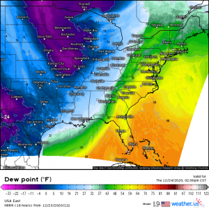
More moisture and warmth pulled from the south = higher dew points. Severe storms generally need dew points about 55 degrees to thrive. Higher dew points encourage more latent heat release which increases instability. The more heat you have, the more rising air (instability) you have. Instability is the fuel storms run off of. The area in the enhanced risk for tomorrow looks to have dew points well into the 60s. That doesn’t lend to a crazy amount of instability, but it may be enough for a few low-topped supercells.
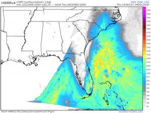
Instability is measured as CAPE (convective available potential energy). Things like latent heat release and day time heating contribute to the available energy. With extensive cloud cover out ahead of the cold front and very little daytime heating going on, it looks like the energy for tomorrow’s severe threat will come solely from the latent heat release associated with the warmth/moisture being advected in. As I mentioned before, with dew points only in the 60s, instability will be somewhat limited. The storms that do form won’t be huge, powerful 40,000 ft top cells since we don’t have an abundance of rising air, but low-top supercells are certainly possible.
The last ingredient, especially for a tornadic storm, is directional shear. Directional shear is a change in the wind direction with height. For tornadic formation, this usually means a switch from SE at the surface to SW in the mid-levels. The sounding above was taken from southern North Carolina, which is in the enhanced risk, for tomorrow afternoon. A large, looping hodograph shows that we not only have speed shear, but directional shear as well. As evidenced by the wind barbs, winds very clearly switch from SE to SW as we progress upward.
So, now that we’ve determined that we have ample speed shear, good directional shear, and limited, but adequate instability, what are we looking at for tomorrow?
Tomorrow’s threat will be two-pronged.
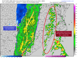
First: in the warm sector ahead of the front, cellular storms may form in response to low-level warm advection. It is likely that these storms could quickly transition into supercells. Herein lies our greatest severe threat. As we already discussed, there is more than enough speed and directional shear to sustain these cells and allow tornado formation. Timing for this first round is tomorrow (12/24) in the afternoon. This can quickly become a dangerous situation so please remain weather aware in these areas and make sure you are able to receive warnings/seek shelter quickly.
Second: In the evening hours, a line of frontal convection will pass through the area. The continuing strong flow aloft may allow for damaging winds to mix down in these storms, making straight-line winds the main concern. However, since shear will still be present, a brief tornado is possible, but less likely than with cellular storms earlier in the day. The line should pass offshore after midnight and the threat will end as sharply colder, drier air rushes in behind.
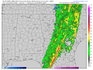
I’d like to add that there is also a marginal risk for severe weather through Florida and Georgia as well from the frontal convection.
Unlike the Carolinas, though, cellular storms are not expected to form in front of the main frontal line. The risks then are much less dire with damaging winds mixing down from aloft and perhaps a brief tornado from a strong storm embedded in the line.
This isn’t a forecast we’re thrilled to see any day of the year, much less on Christmas Eve. All I ask is: if you reside in the areas at risk, please be very weather aware tomorrow. These storms will be moving and evolving quickly and you may not have a lot of time to respond to a threat. If you know someone who lives in these areas, please take some time and warn them about tomorrow’s situation so they are not taken by surprise.
This will likely be my last blog until after New Years as we will be taking a holiday break, so I’d like to wish you all a safe, blessed Christmas and a happy New Year! Enjoy the holidays!
