Bad Timing: Impactful Winter Storm Set To Disrupt Holiday Travel
We’ve spent a lot of time this week (and last) talking about the track for this upcoming storm. But now it’s time to talk about impacts.
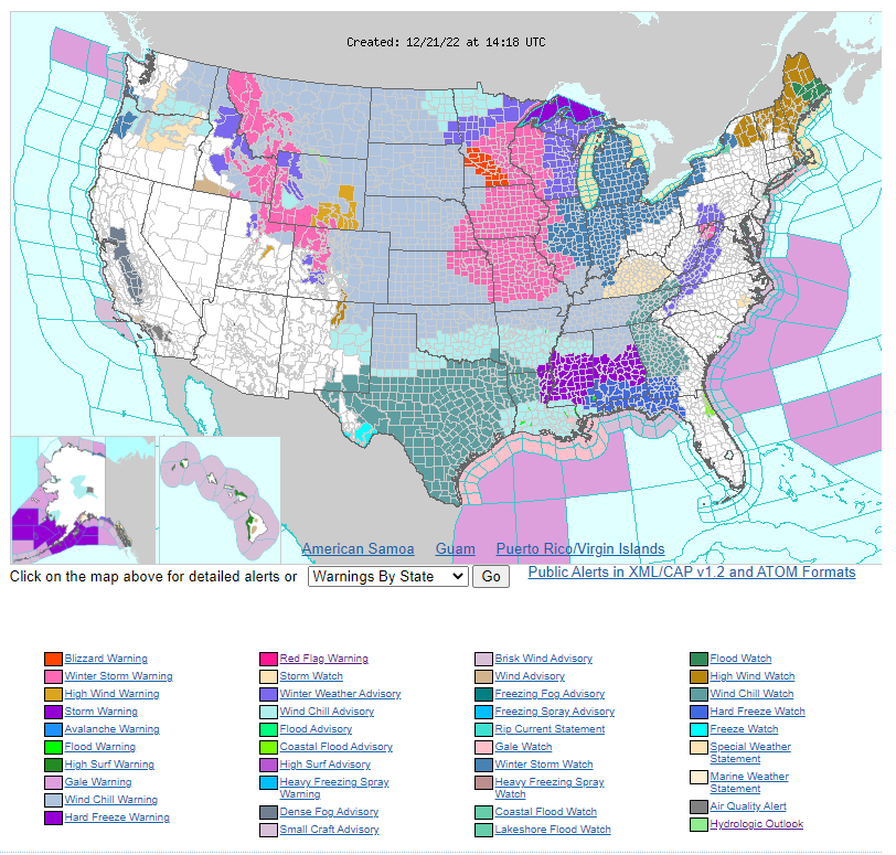
One look at the hazards map from the National Weather Service will tell us that this storm is much more than a snow threat. It will be a large storm with far-reaching effects. Additionally, the cold air it pulls in behind it brings it’s own problems.
Wind
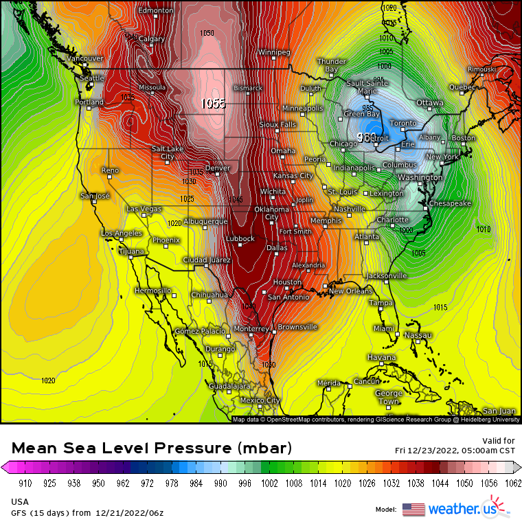
Our system is expected to “bomb out,” or rapidly deepen, as it lifts away northeast.
Rapidly lowering pressure over the Great Lakes region will be at odds with an Arctic high over the northern High Plains. This results in an extremely tight pressure gradient which then results in strong winds as air across the gradient from high to low pressure.
Take a look at the map above. See how tightly packed the isobars are?
Additionally, there is another strong high centered over the Atlantic Canada region. Another tight pressure gradient means strong winds on the eastern side of the low as well.
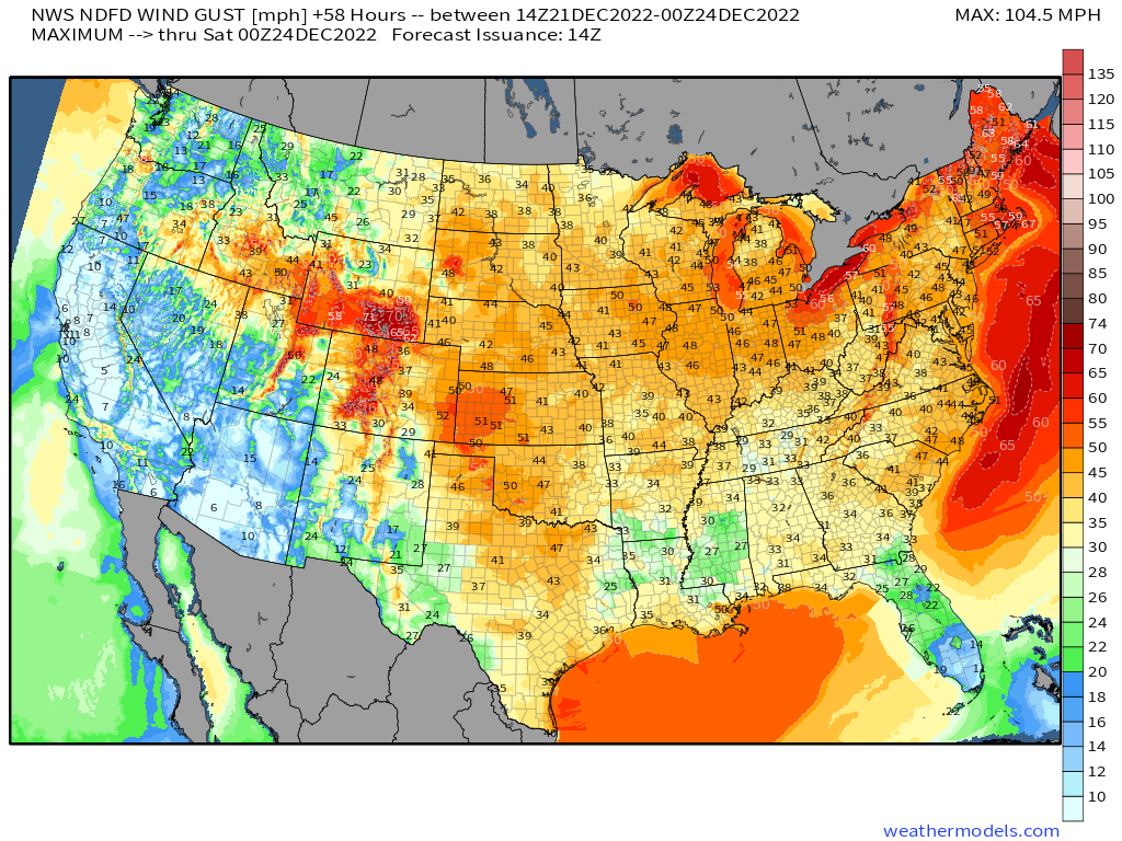
Widespread gusts in excess of 40 mph are likely over a large portion of the eastern 2/3 of the country. Notably higher gusts will be possible over the Great Lakes, near the center of the low, and the Northeast, where a strong low level jet will set up ahead of the front.
The forecasted strong winds bring about a bunch of secondary hazards:
- Dangerous wind chills
- Potential power outages
- Coastal flooding
- Blizzard conditions
Arctic Cold/Dangerous Wind Chills
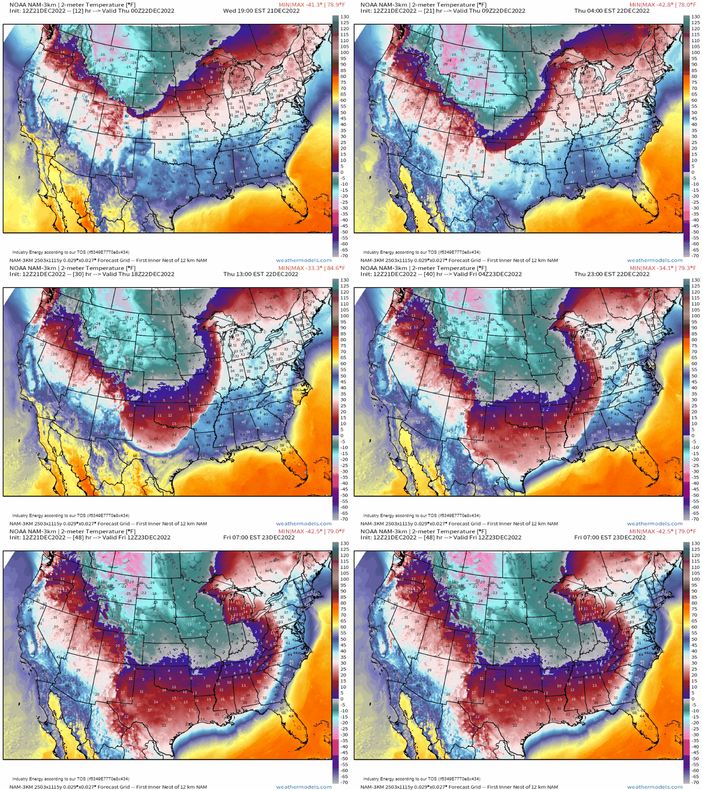
The speed at which Arctic air is modeled to filter in behind the front is astonishing. If it plays out as modeled (which is expected), its completely possible that a location may be in the 40s ahead of the front and then down to the teens 2 to 3 hours after the frontal passage.
This rapid plunge suggests the risk of a flash freeze. Whatever moisture from pre-frontal rain is left standing and isn’t dried by the strong winds gusting through will likely freeze quickly as temperatures drop. This introduces the risk of black ice on roadways. Extreme caution should be used if you need to travel during this period.
Speaking of wind, the gusty winds we’ve talked about combined with rapidly dropping temperatures will facilitate dangerous wind chills for many.

By Friday morning, a large portion of the eastern 2/3 of the US will be experiencing sub-zero wind chills. Some, like those in the Midwest and Northern Plains, could experience wind chills of -30 to -50 degrees! These are extremely dangerous and can cause frost bite in as little as 5 to 10 minutes.
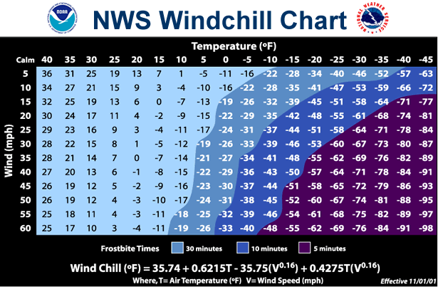
Here’s a handy chart from the NWS for your information.
The bottom line is that if you must be outside during this time, you need to layer up and protect any and all exposed skin from the elements.
Coastal Flooding
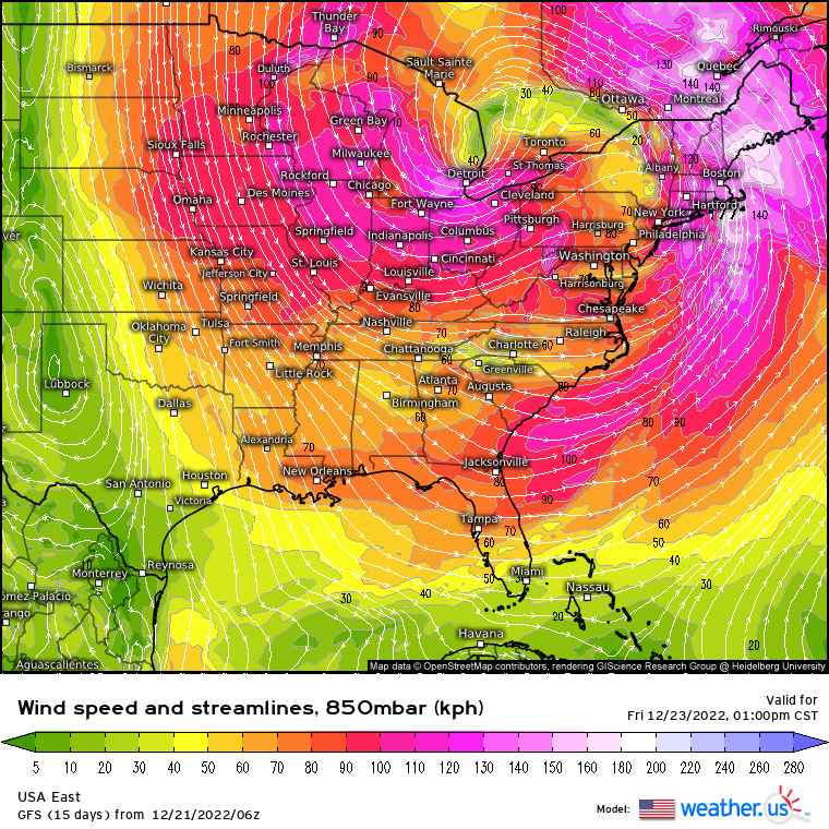
As our cyclone deepens, a strong low-level jet will materialize ahead of the front. Strong winds inside this jet will have the potential to push water inland – kind of like storm surge in a tropical cyclone – which would then allow for some flooding along the coasts of the Northeast.
Additionally, there’s a chance a “sting jet” could form on the back side of the storm as it explosively deepens. As this jet orients itself across the Great Lakes, large waves will be possible as will coastal flooding as the water is pushed ashore. The favorably-oriented flow will go on to power lake-effect snow, which could result in significant accumulations.
Snowfall/Blizzard Conditions
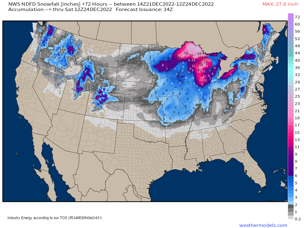
When a winter storm is forecasted, the most common question is, “How much snow will we get?”
While snow is a part of this storm, it’s not the biggest issue. As you can see from the map above, the biggest totals will be found in a relatively small area. Smaller totals of 4 inches and under are much more widespread.
However, for this particular storm, it doesn’t have to snow a lot for the snowfall to be hazardous. Why? The wind.
Sustained winds/gusts like we discussed in the beginning of this blog can create blizzard conditions. In case you are not aware or have forgotten, the requirements for a blizzard are:
- Sustained winds or frequent gusts of 35 mph or greater
- Blowing or falling snow that reduces visibility to 1/4 mile or less
- The above conditions must persist for 3 hours or more
A blizzard is not about the amount of snow that falls. Based on the requirements above, its completely possible that an area that receives only 2 inches of snow still experiences blizzard conditions. Where this occurs, travel will be extremely dangerous, if not impossible. Stay home if you can.
Power Outages

Let’s go back to the widespread, potentially intense winds for a second.
I need to mention the potential for power outages. This is extremely important considering the rapid drop in temperatures behind the front.
Where stronger gusts are seen, falling trees or utility poles may take out power lines. Crews will be unable to get out and repair the damage until the winds have settled. Preparing to stay warm in the event of an outage is necessary.
Tips for keeping warm:
- Layer! More layers = more warmth. Blankets also help
- Close curtains and shades to insulate the interior
- Stuff rags and towels in cracks under doors/windows/etc
- Eat and remain hydrated
- Choose an interior room and make it the main room everyone gathers in – body heat helps!
This storm has the potential to be a truly historic event. Hazards amount to much more than snowfall and cover a large portion of the country. Pay attention to changing conditions in your area. Additionally, try to stay home if you can. If you have travel plans, adjust them if possible. If you MUST travel, prepare for the conditions, including preparing for the frigid temperatures if something happens to your car or you become stranded.
Look for a “last minute” update on the storm in tomorrow morning’s blog from Armando!


Precautions to keep you safew in the snow, especially when stranded: https://watch-fire.net/stranded/