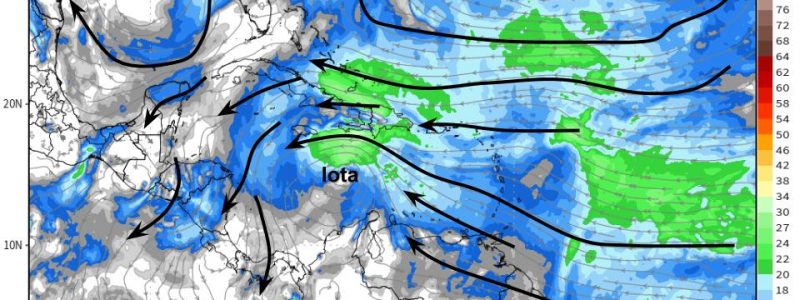
As Eta Moves Inland Over Florida, A Weary Basin Turns to Iota
It’s November 12th of the record-shattering 2020 hurricane season, and the exhausted Atlantic faces yet another potentially significant tropical threat. This blog entry will go over the medium-range track, intensity, and impact outlooks for disturbance AL-98, which will likely soon be declared the 30th named storm of the season, Iota.
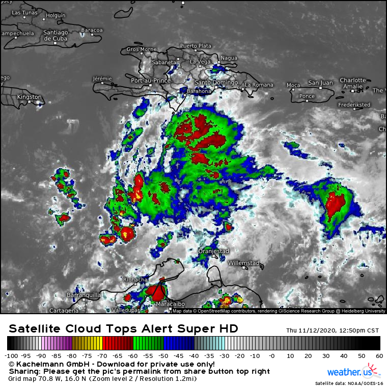
Link: https://weather.us/satellite/708-w-160-n/top-alert-superhd-15min/20201112-1850z.html#play-0-12-4
98L is a fairly well-organized tropical wave, with deep convection demonstrating some degree of curvature and rotation around a central location. The sparsity of convection closer to this center of rotation likely precludes an upgrade to a depression or tropical storm at the moment. However, as organization likely steadily increases over the next 24-48 hours, designation is likely for the system. The NHC has an 80% chance of development within 2 days, increasing to 90% over 5 days. It is quite likely that Iota will be with us by the end of tomorrow.
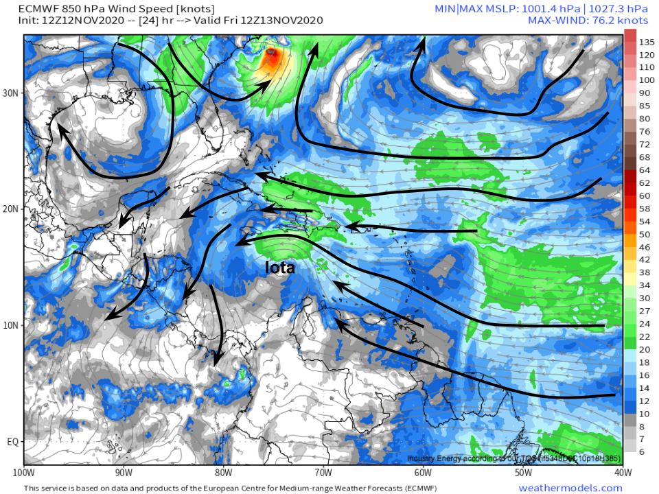
To figure out the eventual intensity and impacts possible with 98L, we have to figure out where the thing is going. As 98L is still relatively weak, winds in the lower third of the atmosphere are likely playing a big role in the short-term steering of the system.
At this level through the next couple days, steering is largely under the influence of the massive ridge over the middle of the Atlantic. This will send 98L a little north of due west along the 15°N latitude line.
Link: https://weather.us/cyclone-tracks/euro/790-w-130-n/2020111206-240.html
This motion forecast is corroborated by the NHC ensemble, which is tightly clustered around taking 98L along the path I just laid out in the short term.
So now that we know where to-be-Iota (which I will call Iota from this point on, because it’s less clunky than 98L, and because it will probably be Iota at this point in the forecast) is probably headed over the next few days. This means we can begin to understand how the intensity will change at the hands of atmospheric and oceanic conditions in its path.
Those with a good geographical memory may recognize this path as nearly identical to the one Eta, at the time a weak system, took as it lurched towards Nicaragua. Because storms often churn up and cool down oceanic water, it’s tempting to consider this a good sign for a weaker Iota. Unfortunately, though, that won’t be the case here, as SST analysis shows. 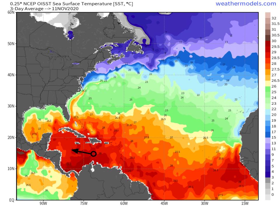
Link: https://lab.weathermodels.com/models/oisst/sst.php
Where Eta was at its strongest and slowest, near northeast Nicaragua, the ocean is a solid 2°C cooler than it was two weeks ago. But further east, where Iota will be tracking over the next couple days, the ocean is as warm or even warmer than it was when Eta visited. This water, at or above 29°C, is very favorable for tropical cyclone intensification. Thermodynamically, Iota will be able in a very favorable environment for development.
Now, let’s look at kinematics. There are two large-scale things to look for: destructive shear that could prevent Iota from organizing, and constructive upper level winds that can promote “outflow” and mass evacuation from the storm’s column.
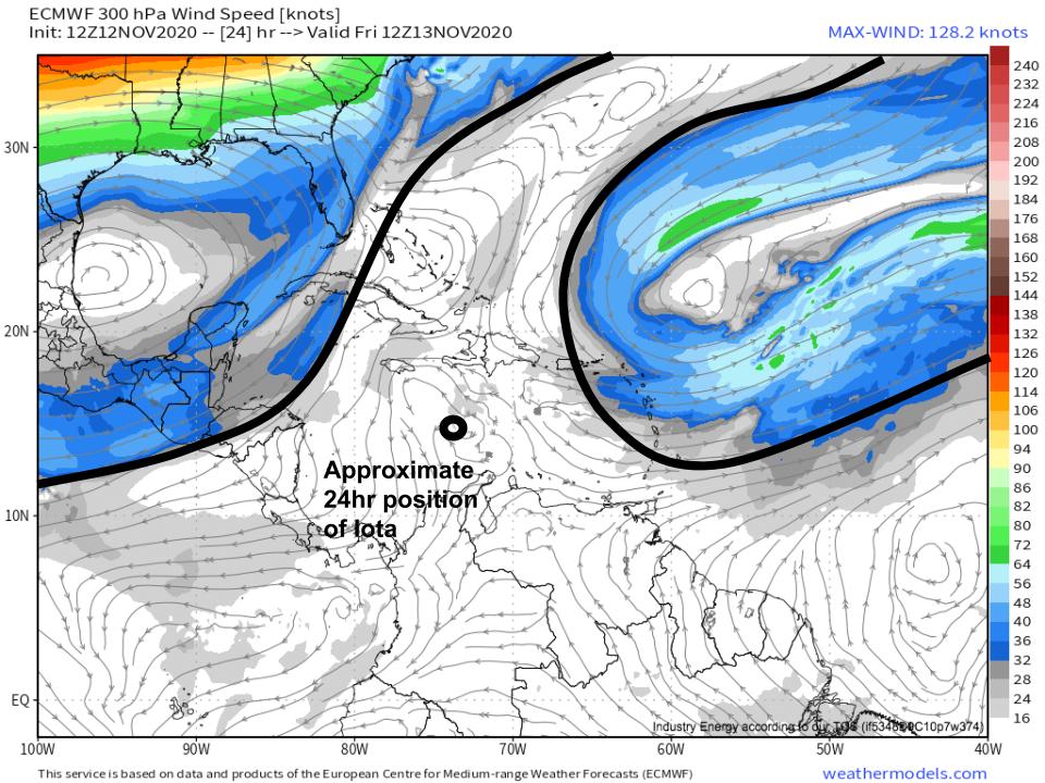
An analysis of the short-term upper levels reveals that Iota will be beneath large scale ridging, which should keep shear quite low. This is good for the storm’s shot at organization over the next couple days.
Also missing, however, is the kind of arcing outflow that helped allow Eta to rapidly intensify to near category five intensity. This is more a case of something that could be favorable missing than the presence of something unfavorable, though.
Finally, let’s look at moisture content along the near-term path of Iota. Tropical storms cannot effectively intensify in the presence of dry air. 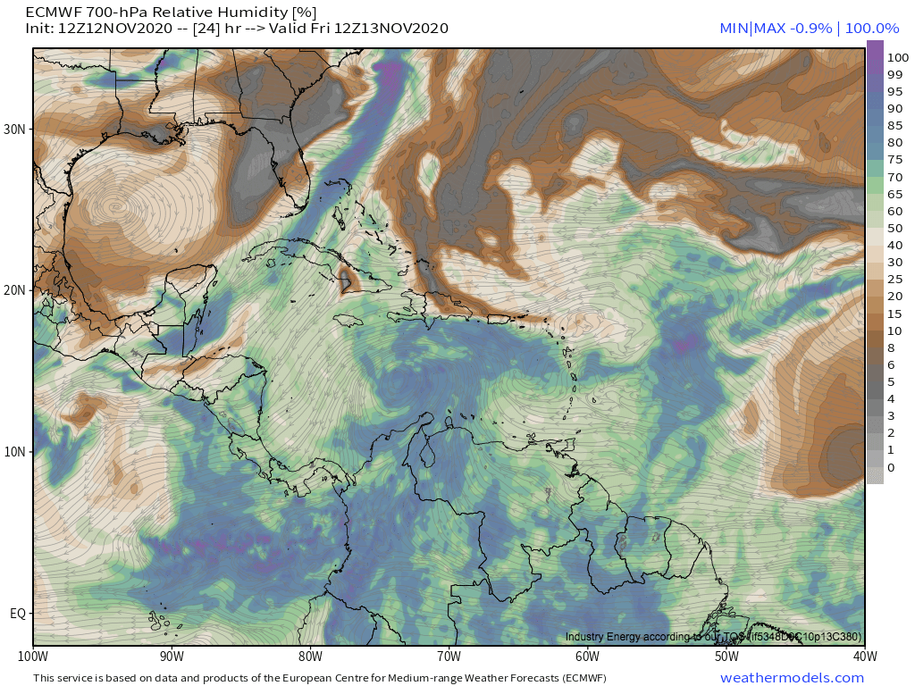
Iota is clearly slated to be in an atmosphere with plentiful moisture. Therefore, intensification likely won’t be moderated in the short term by dry air.
So, we’ve figured out where 98L, soon to be Iota, is likely to go over the next couple days- slightly north of west towards Central America. While traveling, the storm will be moving over very warm waters, in a zone of low shear, and in a large moist envelope. This all means conditions will be quite favorable for continued intensification through the beginning of the weekend. Of course, the speed with which the still disorganized invest develops a CDO will be crucial to intensity in the short term, and so one of the most important things forecasters can do is monitor satellite for upticks in organization.
Now, if you’ve read this far, you may be wondering why intensity matters so much in the short term? Well, by around hour 48-72, models start to diverge on track: 
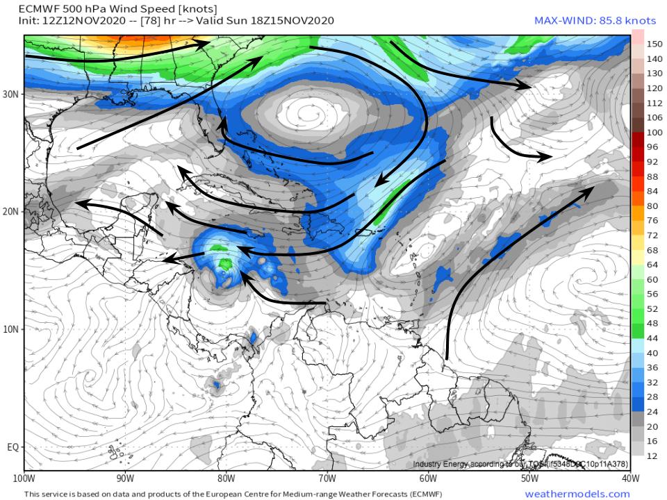
A couple models take Iota on a more north bound track than the rest, which has significant implications to eventual impact. To help us figure which model suite is likely correct, it’s important to look at steering around hour 80.
I have a hunch this discrepancy can be explained by different steering conditions at different heights, which means models that have Iota weaker will have it steered one way by lower level flow, and models that have Iota stronger will have it steered another way by higher level flow.
Let’s look!
 Link: https://weathermodels.com/index.php?r=site%2Fmodels&mode=animator&set=9-km%20ECMWF%20Global%2000z%2F12z%203-Hourly&area=Caribbean¶m=300%20hPa%20Wind&offset=0&thumbs=1
Steering flow at 300mb would direct Iota on an increasingly north of west track as it approaches central America. This means the stronger Iota is at ~hour 80, the more likely it is to be steered north of Nicaragua/Honduras, over more water.
It’s subtle, but there is a stronger west component to flow at the 500mb level than 300mb level at hour 78. This is a result of a more compact, stronger Bahamas ridge lower in the atmosphere, which serves to keep flow rigidly from the east, without much of a north component, lower down.
This means that a weaker Iota is more likely to landfall in Nicaragua or Honduras, and a stronger storm is more likely to remain over the Caribbean sea, north of Honduras.
The Euro ensembles and GEFS ensembles also show this trend, with ensembles that show stronger Iota taking the storm on a further north route through the Caribbean. This corroborates the concept that Iota’s intensity around Saturday will determine the path it takes to a large degree, which will in turn determine eventual impacts.
As I’ve discussed previously, I expect few barriers in the way of intensification for Iota once it organizes enough to take advantage of a favorable atmosphere. Because 98L is already quite organized, and seems to be organizing further at a decent clip, I am leaning towards a stronger and more north solution. But it’s important to remember that we don’t really know yet- the most important thing we can do is to continue watching satellite for development, or lack thereof.
The way I see it, unfortunately, there is no good path for Iota. It could landfall in Nicaragua or Honduras, which would mean Iota probably never reaches the intensity possible in the atmosphere it’s in. However, in this scenario, a relatively slow moving storm would bring heavy rain along convergent bands to Nicaragua and Honduras, while also leading to very heavy rain along favorable topography with onshore flow over Honduras. In other words, the moderated wind speeds would come at the expense of additional catastrophic flooding over a region that just saw widespread 20-30 inches of rain. This would be absolutely devastating.
Should Iota move north towards Belize and Mexico as a stronger hurricane, it’ll find itself in an environment in which additional strengthening is possible. In that case, a storm with significant surge, wind, and rain impacts would be likely in northern Central America.
98L is a powerful tropical wave, likely to develop into 2020’s 30th named storm over the next day or two. When it does so, it’ll be named Iota, and it will threaten many of the same regions recovering now from Eta earlier in the month. The eventual track, intensity, and impacts will depend on the short-term intensity, which itself depends on the speed at which the storm can organize over the Caribbean.
Stay tuned to this blog and our twitter as we track the storm.
