Another Southeast Tornado Outbreak Possible Thursday
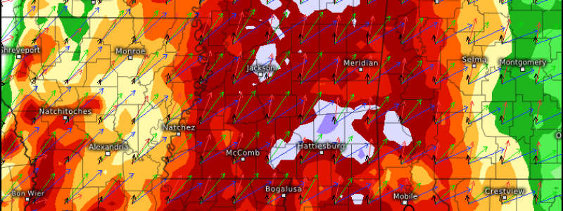
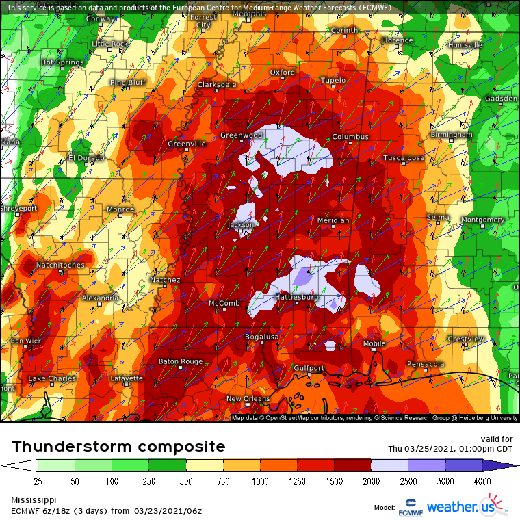
Potential is increasing for another round of convection to rake portions of the southeast with numerous tornadoes on Thursday. While there is still a lot we don’t know, what we do know is at least in part indicative of the chance for an outbreak of long track significant tornadoes.
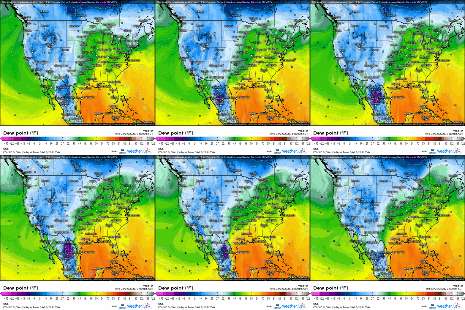
The groundwork for the threat is actually being laid this morning, as an impulse skirts the eastern periphery of a longwave trough enveloping much of the western US. The impulse itself incited a low-end severe thunderstorm outbreak in Oklahoma yesterday, which likely would have been more significant had it not been for the substantial limiting factor of a dry boundary layer. Ironically enough, this dewpoint-starved shortwave will assure moisture return is sufficient to support large-scale convection Thursday.
As the impulse tracks northeast over the next 24 hours, divergence downstream will incite mass removal from the low levels, with a strengthening southwesterly low level jet resulting. This will allow north-oriented advection of a rich Gulf airmass to begin in earnest today, creating a framework of moisture return that will continue through Wednesday.
Wednesday itself will continue laying the next atmospheric groundwork for a dangerous Thursday. As this morning’s lead impulse tracks into the mid-west and loses amplitude to the midlevel jet, a more expansive, intense closed low will pivot into the south-central US.
The closed low itself will sling around the bottom of the longwave in a fairly unusual orientation, opening to an extent into a large but fairly diffuse shortwave trough stretched horizontally. Early on Wednesday, the exit region will incite the development of another low level cyclone amidst the pre-existing southerly flow discussed above. This development will serve to intensify and focus the 850mb jet over the south central US, expanding the magnitude and scope of southerly advection there. Moisture will begin surging north as a result, and by Wednesday night, a fairly high-dewpoint warm sector will be taking shape in parts of the south-central US.
At the surface, as the wind shift that makes up the northern extent of the moisture return interacts with an increasingly strong low level jet amidst an impressive belt of flow aloft, well sheared, mostly elevated convection will likely develop Wednesday night. Large hail is possible, and any surface based storm along or just south of the warm front could well drop a tornado into the wee hours of Thursday morning.
The unusual shape of the diffuse midlevel cyclone will prove important, as it takes on an increasingly elongated orientation. The ‘front’ half will accelerate northeast Wednesday night, with an attendant surface cyclone and low level jet arcing into the midwest. The back end will barrel east more slowly, overspreading the southeast with associated divergence Thursday morning.
In this zone of encouragement for ascent, secondary cyclone development along the Wednesday night warm front will begin in earnest as the sun rises Thursday. As the pressure gradient strengthens into the morning, the already enhanced southerly low level jet will intensify further, allowing a third moisture surge into the Gulf-adjacent southeast. The warm sector by mid morning will have anomalously high dewpoints, the result of a multi-day fetch of increasingly intense moisture return.
This surge of increasingly intense low level flow will also coincide with increasing wind speed aloft, as the ‘bottom half’ of the diffuse trough intensifies and swings east. The result will be a very moist environment overspread by an incredible suite of kinematic support for updrafts to organize and develop intense mesocyclones.
There is also fair agreement on the presence of an instability-boosting EML, and models are optimistic about isolated to scattered cloud breaks increasing surface heating. This could help CAPE reach or locally even exceed 1000-2000 j/kg, a moderate to high-end environment for the southeast in March.
What will probably happen, sensibly, is a round of strong thunderstorms and possibly isolated tornadoes overnight Wednesday clearing most of the southeast by sunrise. To the south of these storms, a quickly improving warm sector for convection, both thermodynamically and kinematically, will take shape over Mississippi and portions of Alabama and Louisiana as the secondary cyclone intensifies over the south-central US. With roaring low level flow and high-end moisture and shear, the environment will be very conditionally favorable for a strong to violent tornado, should discrete convection develop amidst sufficient instability.
As warm air advection interacts with subtle boundaries generated by overnight convection and topographical features, warm sector supercells will be certainly be possible, capable of satisfying this conditional. These could develop as early as noon, and continue through the evening. Development is far from assured, but could prove a very dangerous situation. Unlike last week, a very well timed low level wind field could mean that several storms can produce tornadoes that could be intense and extremely damaging.
One thing to watch over the coming days will be instability, as influenced by midlevel lapse rates, cloud breaks, and the speed at which storms clear the warm sector by the commencement of diurnal heating. The presence/strength of an EML can help determine all of these factors due to the capping and midlevel drying influence the airmass can have, increasing inhibition early and decreasing temperatures rapidly with height. Another factor to watch will be the ability of ‘sleeper boundaries’, subtle open warm sector gradients that can support discrete storm development, to form south of the warm front.
Regardless of warm sector supercell development, the cold front itself will very likely feature a QLCS capable of widespread wind damage and numerous imbedded tornadoes. This could occur nocturnally for some, and is a threat that requires continued vigilance regardless of what happens during the day.
We are still two days out from this potential severe weather event. But between high-end, long-lasting flow promoting a wide warm sector overspread with enhanced helicity, a roaring midlevel jet, and seasonally moderate to high instability, a high-end tornado outbreak appears possible.
Stay tuned, and, if you live in the southeastern US, take time to review Meghan’s severe storm preparation tips here.


