Air Mass Thunderstorms Explained
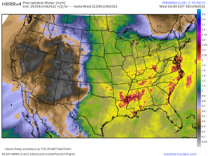
Once again this afternoon, pop-up storms with locally heavy rainfall are occurring across the eastern half of the United States. A potent ridge sits over this part of the country allowing heat and tropical moisture to flow northward.
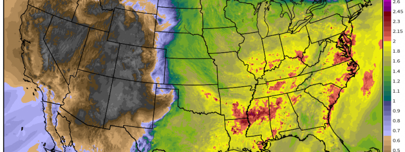
The result is a hot, steamy, moisture-rich atmosphere primed for afternoon pop-up storms bearing locally heavy rainfall. Where these storms have been slow-moving or repeatedly training, we have seen some crazy rainfall totals this week.
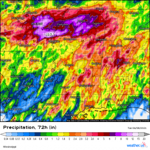
In fact, the 3-day radar estimated total for parts of the south, specifically Arkansas and Mississippi, suggests a whopping 18 inches of rain fell over a small part of southeastern Arkansas.
You may have heard the term “pop-up” thunderstorm many times before. But what exactly are they and how do they differ from, say, supercells or frontal convection?
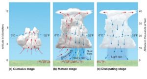
For starters, here’s a little visual explainer:
Pop-up thunderstorms, also known as air mass thunderstorms, are common on summer days when a hot, humid maritime tropical (mT) air mass is in place. Anyone from the south is familiar with this air mass. It’s commonly referred to as “air you can wear.” Unlike supercells, air mass thunderstorms do not require shear. They exist on moisture and instability alone. They are generally less likely to be severe and also are relatively short lived. Without shear, there is no tilt to the structure. Thus, the updraft and downdraft exist within the same space, severely shortening the duration of these storms.
As the summer sun heats the earth, moisture-rich air warms and rises, bringing us to our first stage: the Cumulus Stage. Only updrafts exist here. Typically at this stage, you will see the fluffy, cotton ball-like clouds in the sky. Some could be developing into towers as the updraft works.
It may look something like this:
A field of cumulus clouds in various stages of development. I took this image today on my flight home and it’s really the perfect visual to illustrate the cumulus stage.
From here we move into stage two: Mature Stage. At this point, our cute cumulus clouds have become large cumulus towers or even cumulonimbus with a forming anvil. Both updrafts and downdrafts exist simultaneously. Rain has begun and can be quite heavy. Lightning is common.
Visual illustration:
This is a very tall cumulonimbus with evident outflow and a forming anvil. We were flying at about 20,000 ft here and I still couldn’t see the top of the anvil.
As mentioned before, we now have the both the updraft and the downdraft existing in the same space. Eventually, the downdraft will cut off the inflow, pushing our storm into the final stage: Dissipating Stage.
At this point, the anvil is fully formed and the storm has that classic cumulonimbus look. The very beginning of the dissipating stage can actually be quite dangerous. As the downdraft chokes out the updraft and dry air is entrained into the storm, something known as a microburst can occur. As the dry air enters the storm, it causes the moisture inside to evaporate. Evaporation is a cooling process. This newly cooled air then rapidly sinks to the ground causing a sudden burst of wind that hits the ground and spreads out in a circle of (usually) up to a mile. These winds can be severe, reaching up to 100 mph and can even do damage on the scale of an EF-1 tornado.
Microbursts don’t occur with all air mass thunderstorms, of course, but when they do, they are sudden and very hard, if not impossible, to predict beforehand. Often, they can only be seen after they occur as a sudden appearance of a small area of warmer cloud tops surrounded by cooler cloud tops, which denotes the sudden sinking.
Assuming a microburst doesn’t occur, the storm will merely rain itself out. Additional storms may form on the outflow (rain-cooled air traveling outward from the dying storm).
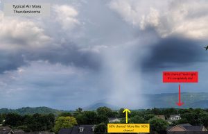
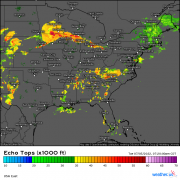
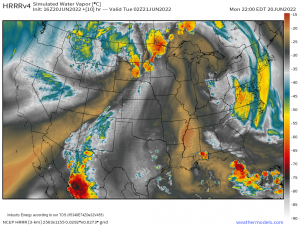
Air mass thunderstorms are notoriously hard to predict with any accuracy. They are erratic, and rarely last long. You will often see your local meteorologists issue a 60% chance of rain on days like these. What that means is there is a 60% (or whatever percent they give) of any one spot getting wet. Models don’t handle air mass thunderstorms well so it is virtually impossible to be specific on which areas will definitely receive rain.
Generally, it looks a lot like this:
So, just because you aren’t receiving rain doesn’t mean your cousin across town isn’t either. These storms are highly random and behave erratically.
Well, that’s it for a short explainer on air mass thunderstorms. Hope you learned something new today!
