Active Weather Across the Country on This Monday
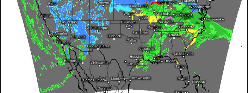
Monday shows us no mercy this week as we hit the ground running with an active weather day for pretty much the entirety of the continental US. We’ve got storms and heavy rain for the south, heavy snow for the Plains, snow and ice for the northeast, and an inbound atmospheric river for the West Coast. We’ll look at this piece by piece.
Severe Storms (?) for the South
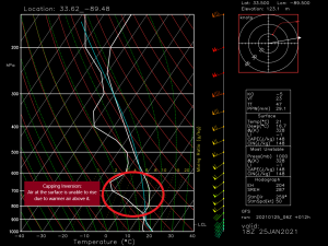
A few things are working against what initially looked like a promising severe outbreak for the south. As we often see during winter, instability is limited. On top of that (literally), we have a capping inversion aloft. Take a look at the sounding above and notice how the temperature line slopes to the right instead of the left. What that means is that there is a layer of air above that is warmer than the air at the surface. This prevents air parcels at the surface from rising, limiting the possibility that storms will be able to form. In order to break this inversion, we would need a decent amount of surface instability to sort of strong-arm it’s way through the cap. Upward forcing would also be of use here, which is something we could see as the cold front approaches later this afternoon.
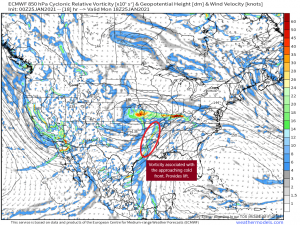
The circled area is the vorticity associated with the approaching cold front. It will perpetuate eastward through the day. Will it be enough to break the cap? Forecasted soundings suggest that it won’t. Still, it’s something to watch throughout the day. Though a widespread severe outbreak is rather unlikely at this point, we can’t rule out a few severe storms. With a speedy low level jet, strong gusts could mix down to the surface inside any storms that are able to form. A weak tornado also can’t be ruled out as we have more than adequate shear aloft. Just remain weather aware today if you live in any of these areas.
Snow
We’ve got two areas of significant snowfall to look at today.
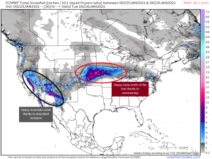
First: The Plains. The same low bringing a severe threat to the south is responsible for the snow in the plains. Abundant moisture is available for this system as it draws it north from the Gulf of Mexico. In a process called overrunning, warm, moist air is in motion above a more dense air mass below. The strong low level jet is bringing all of this moisture north and wrapping it around the low. This moisture, plus the vorticity around the low itself, which is tracking just south of the heaviest snowfall, provides more than enough fuel for heavy snow. This swath of heavy snow will perpetuate eastward with highest totals seen just north and west of the center in the cold sector.
The northeast will deal with this tomorrow, though to a slightly diminished degree. As the available moisture wanes, so will the totals. Places like Pennsylvania and New York will see snow, but not nearly as much as the Plains.
Second: The mountains of the West. Wave after wave of moisture will be impacting the west coast this week. As it lifts into the mountains and cools, it will fall as heavy snow and replenish the mountain snowpack that the valleys depend on during the spring thaw. As much of this area is experiencing extreme drought, the excess moisture is welcome, though it could cause flooding issues down the road. More on the West Coast later.
Ice
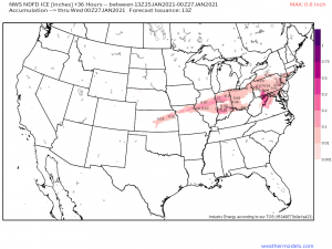
The potential exists for some fairly significant icing in portions of the mid-west and mid-Atlantic today and tomorrow. Here temperatures will be borderline freezing while the air aloft, thanks to overrunning, is above freezing. The shallow cold layer at the surface will allow for any precip that melts in the warm layer to possibly refreeze upon contact. The warm air aloft will be advected pretty far north throughout the duration of the event, which is why we see such a large swatch of possible ice accumulation. The mixing issues due to this air are also why the northeast won’t see the heavy snow totals the Plains are seeing. Seems like it’s always something here this season. A straight snow event has been uncommonly hard to come by.
The West
I’m going to keep this section relatively brief since this is already a long blog. However, this event certainly deserves much more in depth attention so look for a blog from Jacob on this subject later today or tomorrow.
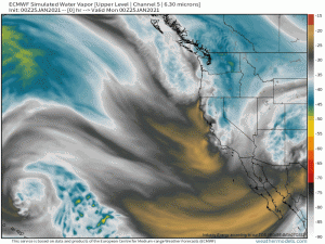
That said, the west coast will be experiencing abundant moisture in the next week. They have already seen a few waves of beneficial rain and snow this weekend but beneficial waves shift to something more impactful come tomorrow. Specifically: a long-duration atmospheric river event. A jet of deep moisture steered by a further-south-than-usual Aleutian Low will target the middle West Coast this week. This will result in heavy rain and extreme mountain snow (we’re talking about multiple FEET here). Although this area desperately needs the rain and snow, there can be too much of a good thing. Flooding will be an impending threat, especially along the burn scars from this season’s past fires. With vegetation destroyed and nothing to hold the soil in place, mud and debris flows could be a possibility. Again, we’ll look at all of this in depth in a separate blog later on.
Those of you receiving snow today/tomorrow, enjoy your winter fun! Those with the potential for ice, especially significant ice, use caution if you plan to be out and about. And finally, those with potential for severe weather in the south today, please remain weather aware with a way to receive warnings/a plan to shelter if you need it.
Enjoy your Monday!
