Active May Pattern Continues with Eastern US Severe, Flooding
A northeastward ejecting southern stream jet streak amidst complex flow aloft will continue a multi-day onslaught of widespread activity, with additional flooding, severe thunderstorms, and tornadoes all probable across much of the eastern US.
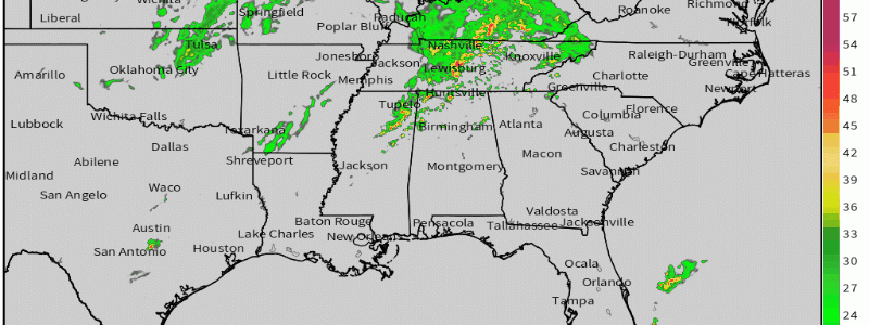
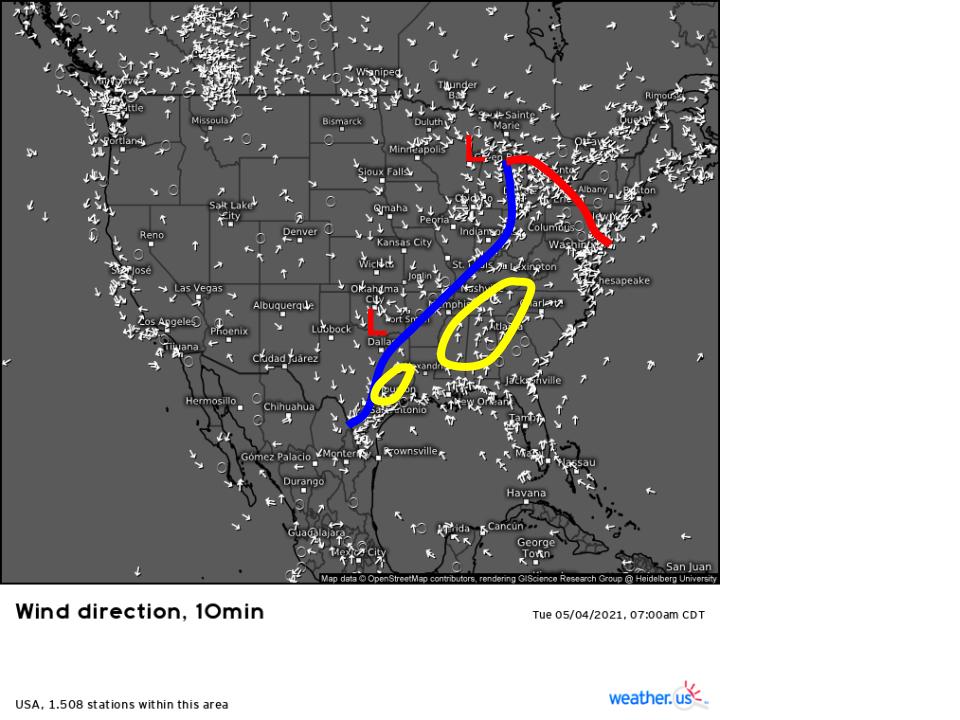
A look at surface obs this morning shows an apparent mid latitudinal cyclone over the Great Lakes region, with a cold front draped south/southwest, corresponding to a diffuse zone of relatively low pressure. Over ArkaLaTex, meanwhile, secondary cyclogenesis is occurring along said front. There are two zones of convection, one expansive over much of the southeast and one less so in Texas. I’ve shaded them yellow here.
Ahead of this frontal system, a moderate but very expansive southerly low level jet is helping moistening reach the crescendo of a multi-day effort, and dewpoints will exceed 70ºF as far north as the Chesapeake, and exceed 60ºF as far north as Lake Ontario.
Meanwhile, the midlevel jet streak I mentioned will overspread almost the entire eastern US with bulk shear exceeding 30 knots. While it shouldn’t be *very* strong for many, it’ll be *sufficiently* strong for organization of convection into storms capable of producing severe weather.
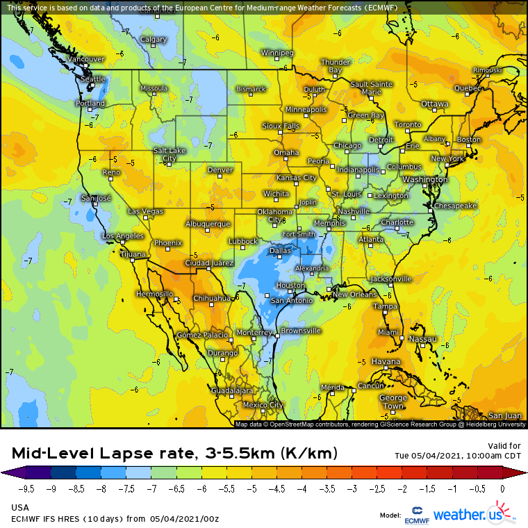
Remnants of the EML that was on full display yesterday have since been partially modified by deep convective overturning (see: yesterday), but remain potent enough to overspread this moist near-surface with lapse rates often at or above 6.5ºC/km. Some parts of the mid-Atlantic are even seeing unseasonable MLLRs as high as 7.5ºC/km.
This combination will lead to substantial CAPE for much of the eastern US, developing through the morning and reaching a “peak” with heating in the mid-afternoon. By then, a huge swath of the eastern US from Houston to the Atlantic coast, north to Binghamton and Philadelphia, will see CAPE exceeding 1 kj/kg. For a large swath of the central Southeast, values of 3-4 kj/kg are likely. With high instability, sufficient shear, and moderate kinematic support in the lower levels, multicellular clusters and QLCSs will be favored modes today.
This leads us to a discussion on the fate of the two remnant convective clusters over the southeastern quarter of the US.
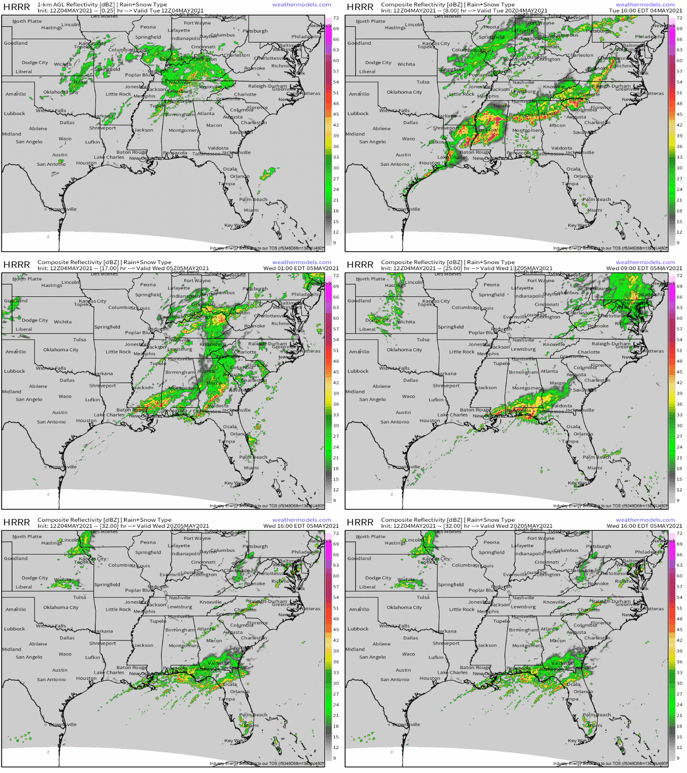
The first, centered over Tennessee, will continue east while developing to the north, over the eastern Great Lakes. The northern half of these thunderstorms will remain multicellular, and should largely stay sub-severe. The southern half will continue to evolve into a messy QLCS capable of producing all severe hazards, including some tornadoes, but should mostly produce damaging wind. Where the QLCS sags into the Birmingham and Atlanta metros later, moving largely parallel to midlevel flow, flash flooding concerns could develop.
Further southwest, the second cluster, over a small part of eastern Texas, will lead to other problems. As storms approach Houston over the next couple of hours, they will intensify in an already quite unstable environment. Meanwhile, additional storms will explode to the northeast, over Mississippi and Louisiana. Corresponding large hail threats will quickly shift to significant damaging wind threats as these storms grow rapidly upscale into a QLCS over LA, which will surge east towards the QLCS over Alabama and Georgia.
The storms will evolve southeast, producing widespread damaging wind before weakening overnight. A second zone of high flash flood risk will develop where this new hybrid QLCS stalls and redevelops amidst parallel flow aloft, over the coastal regions of MS, AL, and FL.
To repeat: while thunderstorms are eye-catching and dangerous, I think the most significant threat today will be flash flooding.
It’ll probably focus in two places: the corridor from Birmingham to Atlanta this evening, and the central Gulf coast late tonight into tomorrow. Be weather aware everywhere in the southeast today, but especially there, and if flooding obscures a roadway, turn around, don’t drown!
Stay tuned for updates.


