A Two Part Severe Threat Targets the Southeast
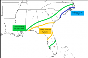
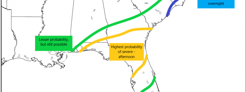
It’s another day of wild weather as the system that brought snow and ice to the south heads east, inciting more severe weather. Today, though, the threat isn’t just for Florida. We have the possibility of two rounds of severe weather: one in the southeast later this afternoon and a conditional threat for the Carolinas overnight.
A surface low currently located in the Gulf, will progress northeast this morning. It will combine with a weak low located over inland Alabama and together they will lift into the mid-Atlantic. As they do so, parts of the southeast will be ushered into the warm sector which will prime the atmosphere for destabilization.
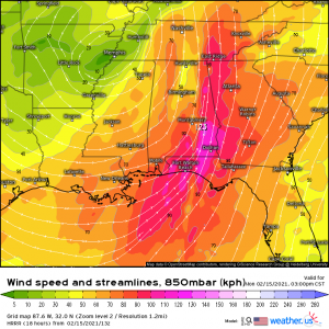
A speedy low level jet will work to advect in enough moisture and warmth under the warm front to incite enough instability for storms to form. In Florida, where it’s been warm all weekend, it won’t take much of a push for ideal conditions to be realized. The Carolinas, though, are a different story. So let’s look at these separately.
The Southeast
The warm front is expected to be able to lift into southern Georgia and it is here along the northern Florida/southern Georgia line that we will find our greatest risk for severe weather. A line of storms will form ahead of a cold front in the Gulf and perpetuate eastward through the afternoon. Though dew points will be nearing 70+ across the area, speed shear will be much more favorable closer to the boundary of the warm front. Central Florida, with shear values of ~30 kts is less likely to see supercell formation than northern FL/south Georgia where shear will be in the 50 to 60 kt range.
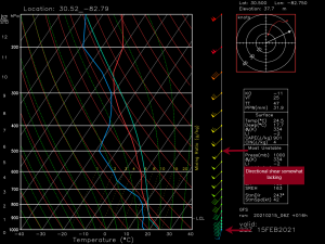
While the speed shear is more than adequate, the directional shear is somewhat lacking. We need directional shear in order for the storms to rotate. Rotation is what distinguishes a thunderstorm from a supercell. It’s also required for tornado formation. In the sounding above, forecasted in the warm sector this afternoon, we see winds at the surface out of the SSW while winds aloft are slightly more out of the SW. That’s very little directional shear. Ideally, we’re looking for surface winds from the SE and winds aloft from the SW. So, while we may see some supercells or bowing segments in a line of storms, strong winds and hail (thanks to decent lapse rates) are the more probable threats today, though we cannot rule out a tornado or two. Just because the shear profile isn’t ideal doesn’t mean it isn’t enough.
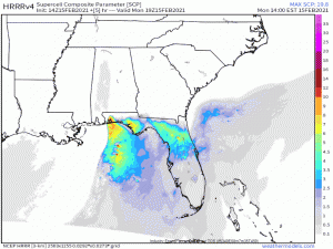
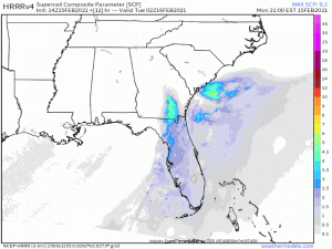
Looking at the supercell parameter, it’s pretty much exactly what I just wrote. Beginning this afternoon, the severe chances increase from west to east along the immediate Gulf coast and far southeast near the limits of the warm front.
This morning and early afternoon will likely be warm and maybe even have some breaks in the cloud cover. If you’re taking advantage of the warmth outside today, you need to be weather aware. Really, everyone does. Over the last two days, both severe threats for Florida have produced tornado warnings and they were much less ideal of a set up. A confirmed EF0 did decent damage in Pinellas county early Sunday morning while a tornado warning was issued just north of Daytona yesterday afternoon. The confirmed tornado occurred in a marginal risk set up, and, most dangerously, overnight. Today’s threat is a daytime event, luckily, so being weather aware is easier. Just be sure to be able to receive warnings and take shelter if needed.
The Carolinas
The severe threat for the Carolinas will be confined to the immediate coast, overnight, and a conditional threat. Why a conditional threat? Well, the Carolinas have spent the last few days cool and rainy. The atmosphere isn’t exactly conducive to severe weather as it stands right now. We will be depending on the warm front and how much destabilization can occur. Should it underperform, there may not be much of a threat at all. Should it overperform, the threat may be expanded.
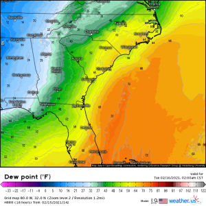
Current guidance has a 120 kt low level jet advecting dew points in the low to mid 60s into the coastal Carolina region after midnight tonight. Notice the time the warm air arrives: after midnight. Though dew points will be adequate, there will be no lingering daytime heating to sort of help out in the instability department, keeping CAPE values on land relatively low – maybe 500-700 J/kg – while the better instability stays offshore. There will, however, be strong speed shear available (40-60 kts).
The lack of CAPE suggests that the main threat here will be damaging wind gusts if they can mix down from aloft in the thunderstorms. However, with strong shear available, should we see further destabilization beyond what is forecast, conditions may become conducive to supercell and tornado formation. That’s not to say that it can’t happen with the currently forecasted conditions. A supercell or two may indeed be able to form and, if it does, could produce a quick tornado.
As mentioned, this is mainly a coastal threat. It will slide northeastward up the SC and NC coast closer to midnight tonight and then offshore.
It might seem like I’m stressing the timeline for this threat. I am. Overnight threats are the most dangerous since people are asleep and not typically weather aware. Watches sometimes aren’t posted until a decent portion of the population is asleep and they don’t realize they need to be on alert. So I’m telling you now, if you reside in these areas: stay alert tonight. Have multiple ways to receive warnings. Have a plan to shelter if needed. This is a conditional threat to a point but even conditional threats produce life-threatening weather given the right nudge. Example: the recent EF3 tornado in Fultondale, AL which formed under a conditional threat. Keep up with your local coverage today and tonight to see if the forecast changes at all during the day with any new developments.
Jacob will be putting out/has already put out a blog on the winter weather portion of this system, so if you’re looking for analysis on that part, be sure to look for his post! Have a great day and STAY SAFE!!
