A Short-Lived Arctic Outbreak For The Northeast This Weekend
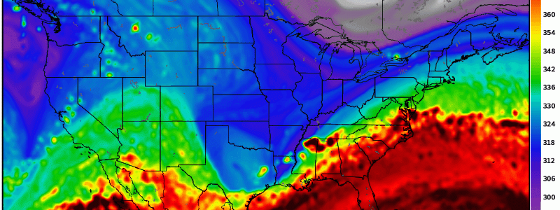
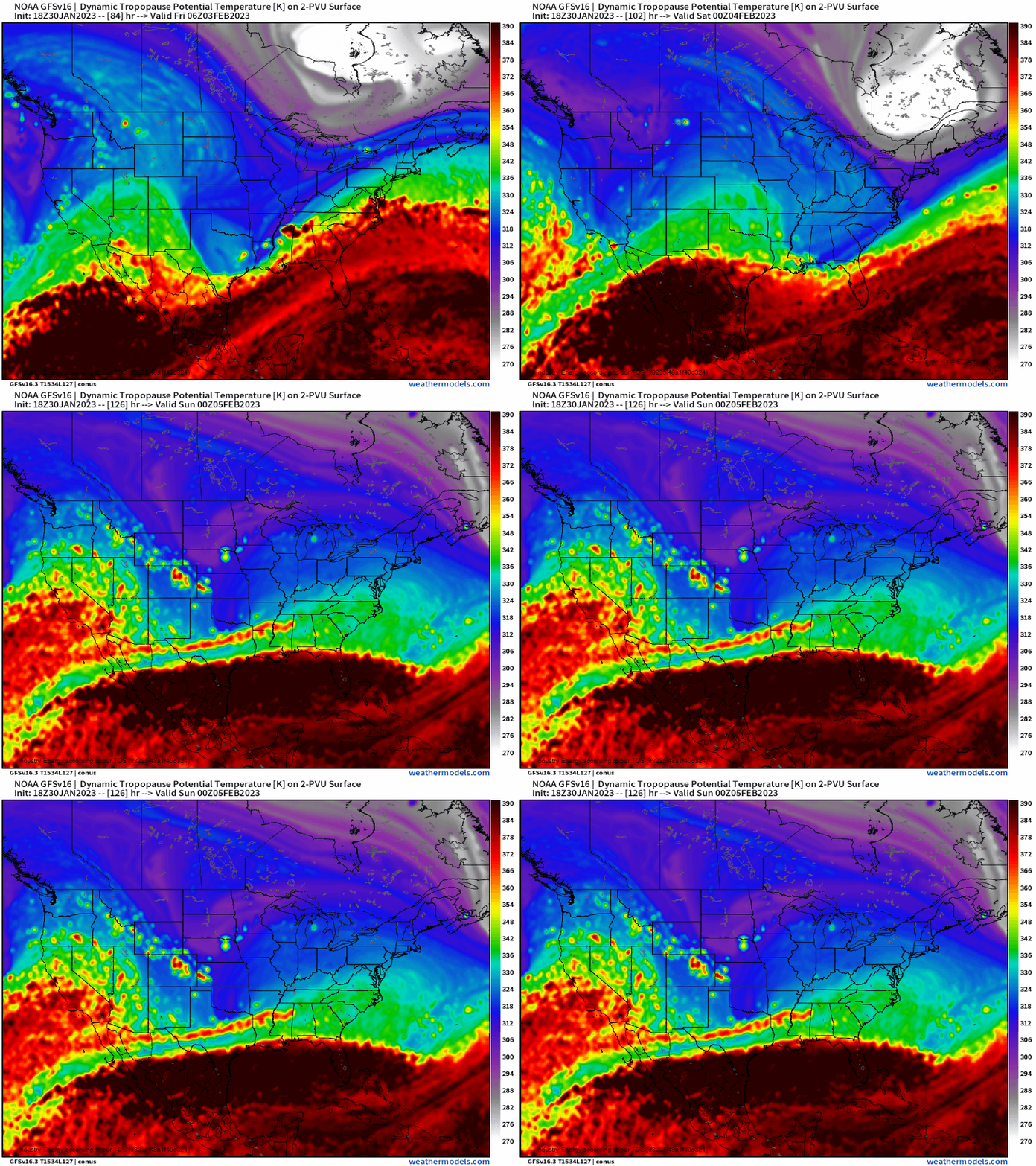
One way we can trace parcels back from their origin, is utilizing tropopause theta (potential temperature). In a very simplistic sense, potential temperature is a proxy for vertical distance between the surface of the boundary layer and some height of the atmosphere. If you were to take a parcel for example at lets say 100mb (~53,000ft), bring it to the surface (which warms adiabatically meaning no exchange of energy between the parcel and surrounding environment, and as you get to the surface , pressure increases on the parcel), it’d have a higher potential temperature vs. a parcel that started out at 500mb (18,000ft). In this case, since cold air is so dense (denser than warmer air), let alone arctic air, you’d expect that it’d would have a much lower potential temperature value. We clearly see that below as it’s color-coded. If you watch the animation of the dynamic theta loop valid Friday to Sunday, you’d likely have your eye drawn to the bright white color. That happens to be a piece of the tropospheric polar vortex, which is of quintessential arctic air. We’re going to see this “swipe” New England, bringing with it a short-lived arctic outbreak.
In the context of mid-latitude forecasting using the dynamic tropopause parameter, a good rule of thumb is that anything below ~285K is associated with arctic air. Verbatim, the GFS show values reaching below 275K down to NH and VT, while the higher values get into cold, polar air as you reach the dark purple colors (up to near 315K). Regardless, this is going to be the coldest air seen for this region since Christmas week, and the most notable of the year since we flipped the calendar!
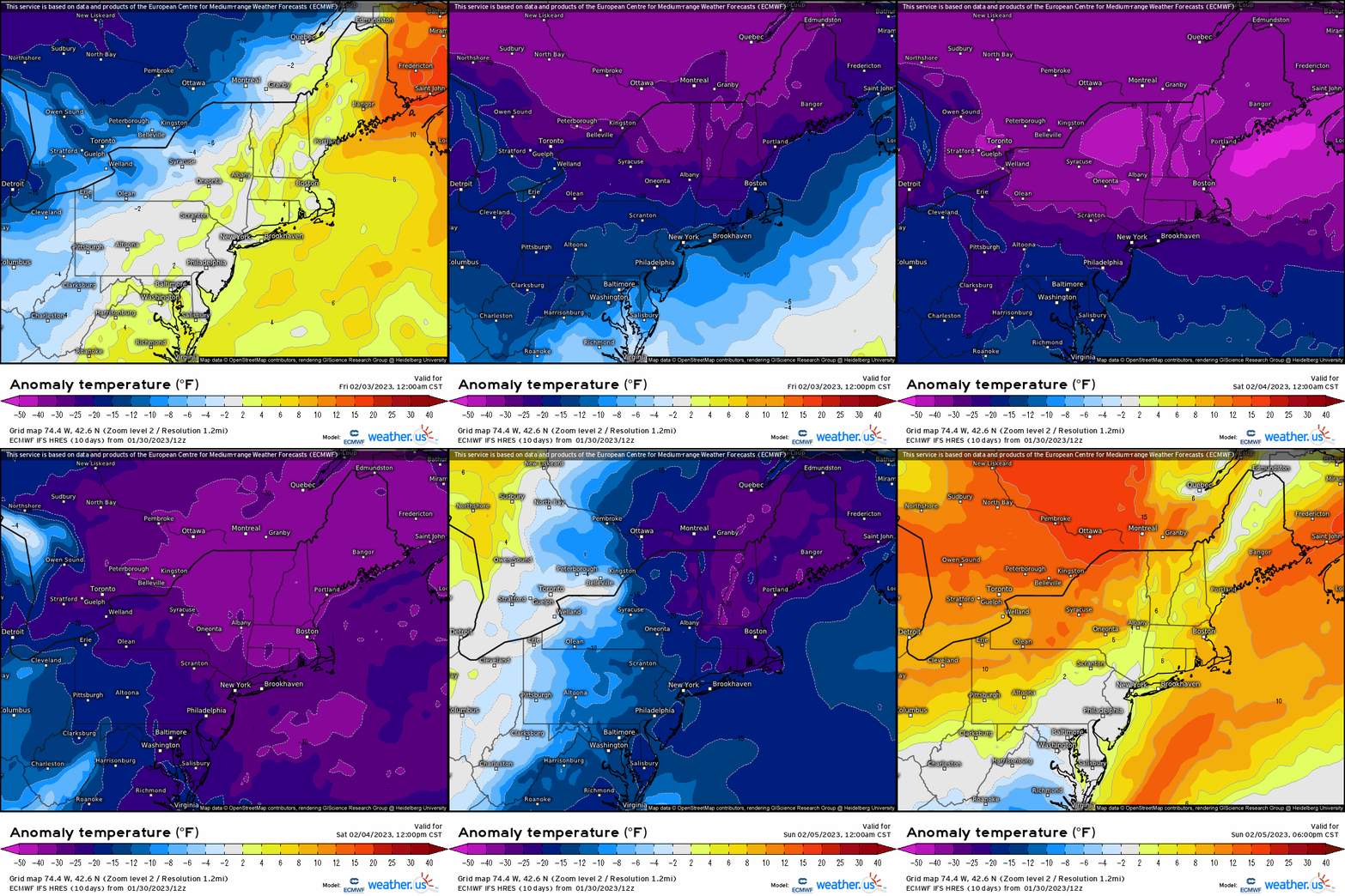
What does this translate at the surface? In terms of temperature departure, we’re going to see an impressive 20 to as much as 40(+) degrees below average across the Northeast. In particular, the more dangerous cold is poised to remain more confined toward New England, with still very cold arctic air getting far enough south into the Mid-Atlantic.
What makes it even worse, is the wind chill factor. Once again, the dangerous wind chills, which appear to approach over 25 degrees below zero, will be focused more across the Northeast, though still getting down to the single digits and near zero further into the Ohio Valley and northern Mid-Atlantic. The most notable time-period for impacts looks to be Friday night into Saturday morning, and again overnight Saturday. Saturday highs will struggle to even get into the 20’s down across the northern Mid-Atlantic; the upper teens to near 20 further into southern New England, and above zero degrees north of MA and central NY!

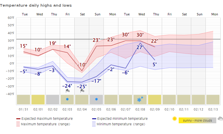
Another way to visualize how impactful the sensible temperatures will be this weekend is through meteograms. Through randomly picking several different locations that represent geographically certain areas of the Northeast & Mid-Atlantic, we can see the high’s and lows for this weekend for Caribou, ME, Albany, NY, Boston, MA, NYC, and Baltimore, MD. Notice for Caribou the forecasted high fails to get to zero degrees, and the nighttime low for both Friday and Saturday are dangerously cold! NYC will get quite close to zero degrees, however, with the lack of snow cover it’s hard to accomplish and especially with the urban heating! Further south of course it becomes “warmer”, though still very cold air! Down by Baltimore, we see well below average 1-day temperatures, with very cold nighttime lows.
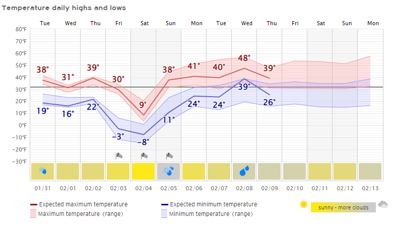
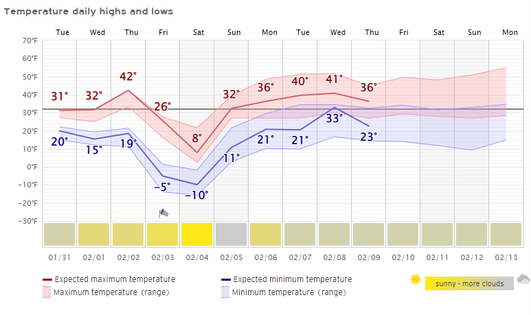
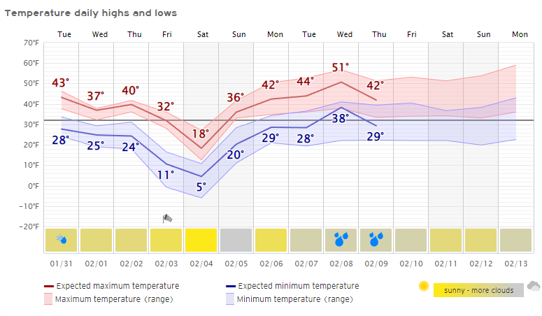
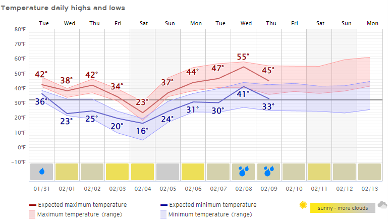
However, like what the title proclaims, it is indeed short-lived! As fast as it comes, it’ll equally be just as quick to leave. In fact, look at the turn-around in 48-72 hours by showing the EPS 1-day average anomaly. We go from over 20-30 degrees below average Saturday, to 5-15 degrees above average by Tuesday into Wednesday of next week!
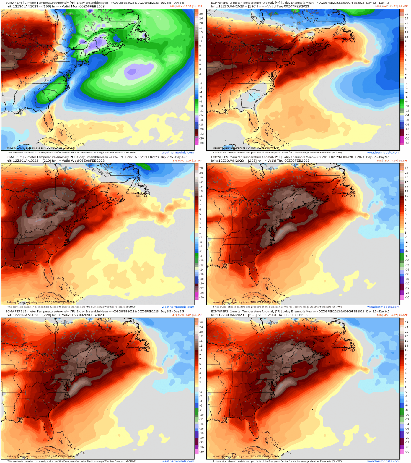
Like we’ve seen all winter, it’s been a pattern of transience for the East Coast and Northeast with a good deal of ups and downs in a winter of above average temperatures since Jan. 1st and a basically snowless winter for many locations. Unfortunately, this is going to be merely a dry weekend with really no snow or wintry precipitation to show for it. Despite no snow, we still have some winter left and cold patterns still ahead.


