A Retracting Scandinavian Ridge – It’s Long-Range Significance & Implication!
One thing as a long-range forecaster that keeps in the “back of the mind” at all times every winter, are signals. Signals and clues that have been developed and researched over the years, where evidence of a plethora of case studies have proven time-and-time again that one cause-and-effect, leads to another with a possible correlation. This signal that is being shown on all ensembles and even deterministic models, is the famous Scandinavian “Ridge-Bridge”, that leads to drastic forecast implications both upstream (US) and downstream (Europe).
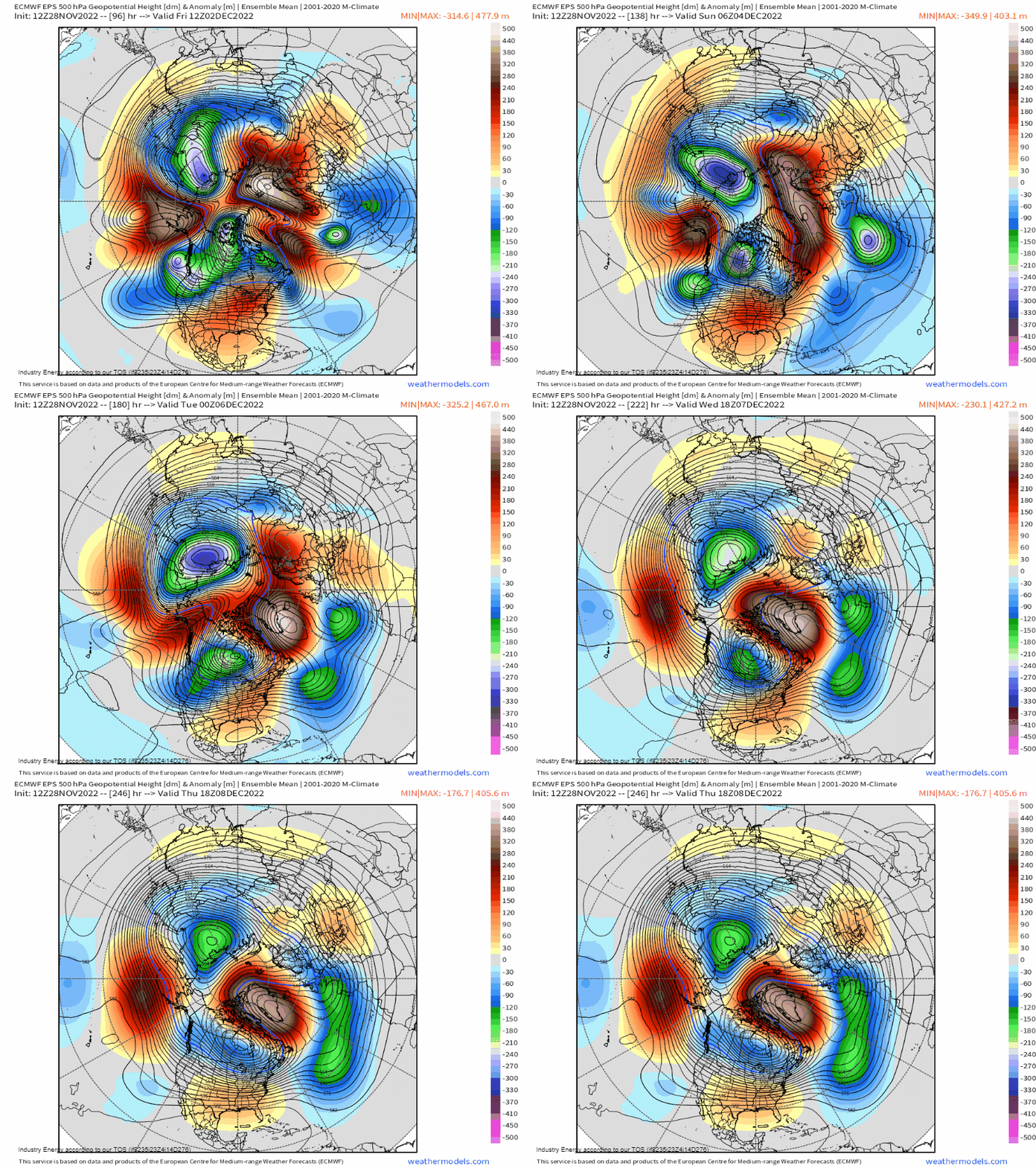
What do I mean by thus? Lets take for example, the GEFS and EPS by highlighting the evolution beginning late this week and into next week:


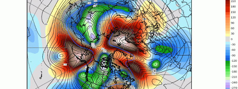
Above, several things happen all in a sequence: the anticyclone that initially billows across Scandinavia and northern Europe, gradually shifts and retracts westward into Greenland. Usually, we see rossby waves like this, simply cut-off or progress with the westerlies (from west to east). However, this case is unique because it builds westward as aforementioned. Secondly, what reinforces this is a rex block that develops with an upper-level low (ULL) that meanders across the Northern Atlantic and West of Portugal. Third, it’s blended and smoothed since this is an ensemble (a collection of numerous individual members), but there is what we call cyclonic wave-breaking (i.e. low pressure systems rotating through a longwave trough that imparts meteorological processes like latent heat release that influence ridging just downstream like increasing heights); this also helps reinforce said Greenland ridging.
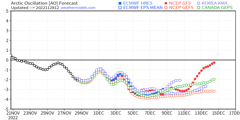
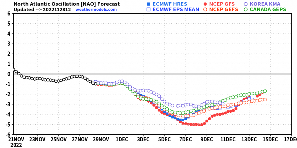
So it’s this retrogression of the ridge from Europe into Greenland, that demarcates a classic high-latitude blocking setup A.K.A. -NAO! Just look at how impressive this is reflected via an index, where numerical weather models show a consensus of over 3 standard deviations above climatology, or where the average is typical in terms of heights across this domain! Not only will a -NAO manifest from this, but even the arctic oscillation (AO) will dive deep into negative territory as well! In fact, the AO also will clock in at over 3 standard deviations!


Now lets watch the beauty of what high-latitude blocking does, and why so many winter enthusiasts and fans alike cheer this on, or get all “tingly”. Watch how Greenland and into the Hudson Bay/Davis Strait turns orange – indicative of higher than normal heights imparting above average surface temperatures. Then subsequently, watch how all of a sudden, the blues and purples (cold, polar arctic/polar continental air masses) expand and become widespread. These air masses then “bleed” into the heart of the country, before slowly pushing east while modifying to a certain extent.

This whole process shifts the polar jet stream southward across the U.S. and Europe as well, flooding the continents with cold air. Also, another huge reason why winter fans alike get excited is because it’s this blocking action, essentially slows the entire pattern down. This slowing down can allow big storms to manifest, like phasing, or slowing down the entire waveguide to allow cold air to get into place before the storms occur. This especially is bound to happen for places like the Midwest and into the Northeast come the middle of December or so, and is one of the classic long range signals! So anytime in the winter we see this type of large-scale pattern evolution into Greenland, know that a legitimate -NAO signal will emerge and that’s when we look for storminess and cold to occur across the U.S. and Europe. Exciting times ahead for winter fans!


