A Prime Example of a Chaotic Pattern for Tropical Forecasting & Fiona’s Future
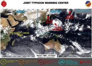
Lets begin out in the Western Pacific where this week, we have had three tropical cyclones with two that reached typhoon status . This can be seen via JTWC (Joint Typhoon Warning Center) for perspective. This was from Thursday, September 15th.
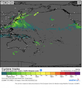
Initialized a few days ago, notice the ECMWF ensemble storm tracks that show the recurving nature of several, which include “Merbok” (post-tropical storm that’ll generate extreme conditions such as waves over 50 feet and hurricane force conditions across the Bering Sea – a storm as such that hasn’t been seen this impactful for this region for decades) and typhoon “Namadol” – a powerful tropical cyclone (Category 4 equivalent) that’ll impact Japan before recurving. It’s this recurving and transition into post-tropical systems that have major ramifications across the Pacific, that end up influencing the Rossby-wave pattern across North America; it also isn’t just Namadol’s doing, but the others play a role in influencing the jet stream!
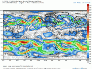
Paying attention to the Northern Pacific alone, you can denote the deeper coloration of the jet stream, implying strong jet streaks! The Pacific Jet with the recurvature and extra-tropical transition of these tropical systems, amplify the entire wave pattern (Rossby wave train) as the jet stream gets a “super-charge” from the meteorological processes that take place. Here shows the 200mb wind speed to display the jet stream (ECMWF EPS).
Now, what are these implications downstream, that ultimately play a very significant role in the steering flow across the Atlantic?
1.) Causes low confidence in predictability passed day 3-5 for forecasters.
2.) Numerical weather prediction volatility is high.
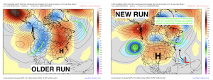
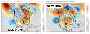
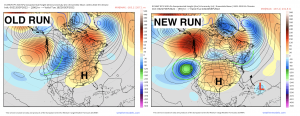
The second point can be easily shown by displaying ensemble mean initialization runs from two different times within a span of a few days. The first set are the GEPS, EPS, and GEFS that were initialized on the evening of the 12th (00z/13th). Look specifically at the broad, progressive western trough and the ridge across the Eastern Seaboard. Fast forward to the runs of 00z/17th and notice the distinct shift of the entire pattern across the U.S. The western trough has now deepened to the point of cutting off from the mean flow off California, which amplified the downstream ridge while shifting westward, and further allowing lower heights along the Northeast & NW Atlantic. It’s this shortwave trough over the Northeast that’ll be a major player regarding the steering flow because this trough creates a “weakness” on the western flank of the large subtropical Atlantic ridge. It creates an “opening” for Fiona to escape, once it’s strong and vertical to “feel” the mid/upper-level winds as it reaches hurricane status this weekend. This is a prime example of how upstream across the Pacific and recurving tropical systems, yields downstream implications and model chaos! The exact positioning of this ridge is critical because there’ll be an inflection point of Tropical Storm Fiona once it emerges from Hispaniola.
(Link)
GEPS
GEFS
EPS
Fiona’s future entails several events through next week:
- Today and into tomorrow, Fiona will trek slowly WNW, bringing the center near the Virgin Islands, Puerto Rico, and the Dominican Republic. However, it’s forecasted to only move several miles per hour as it nears PR and then continuing slowly as it reaches then the DR into Monday. This net slowing down will result in heavy rainfall and significant flooding for urban areas, with mudslides another concern. Tropical storm-force winds also will occur, and hurricane-force winds will result once it intensifies.
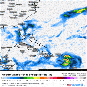
Below displays the total amount of expected rainfall through early next week via 12z GFS. Up to as much as 15″ is possible for areas such as the Virgin Islands, Puerto Rico, and the Eastern portion of the Dominican Republic. A general 3-8″ is likely for a large majority of the Lesser Antilles and eastern region of the Greater Antilles.
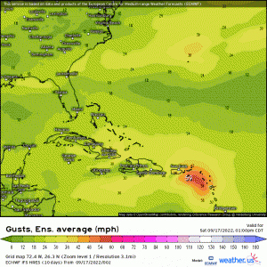
The EPS average forecasted average wind gusts below helps to illustrate the tropical storm-force winds and conditions that’ll impact Virgin Islands, Puerto Rico, Hispaniola, Bahama Island chain, and eventually possibly Bermuda although the latter will have to be an issue to monitor next week.
- Fiona will also be encountering less vertical wind shear over the next day or so. This implies that Fiona will likely reach Hurricane status as it then slowly strengthens, once nearing Puerto Rico.
- By Monday, it’ll approach Hispaniola bringing with it also heavy rain and wind. Once it encounters the mountainous terrain, weakening is likely to occur. Uncertainty regarding how much it weakens – if it does – depends on the track, and then thereafter. This is something that’ll be monitored daily!
- Beyond Monday, Fiona is expected to strengthen as it’s this whole time, shifting WNW and then northward after it passes Hispaniola. This track is also going to render tropical storm conditions for portions of the Bahamas and the Turks and Caicos islands, with the latter also likely to experience heavy rainfall, before then curving into the southwestern Atlantic. By then, we’ll have to watch where it goes as Bermuda may be at risk for concern once Fiona is likely back up to Hurricane status.
- Next week, Fiona still will be trekking across the Western Atlantic as the steering flow likely “lifts” Fiona outward out to sea, but this part contains high uncertainty. The weakness in the trough annotated above needs to be monitored on its propagation and intensity, as there is a solution on the table that Fiona meanders a bit too long out in the Atlantic and could theoretically be steered toward the U.S. The latter has a very low chance of occurring, but something that could still transpire (most likely will not happen).
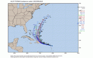
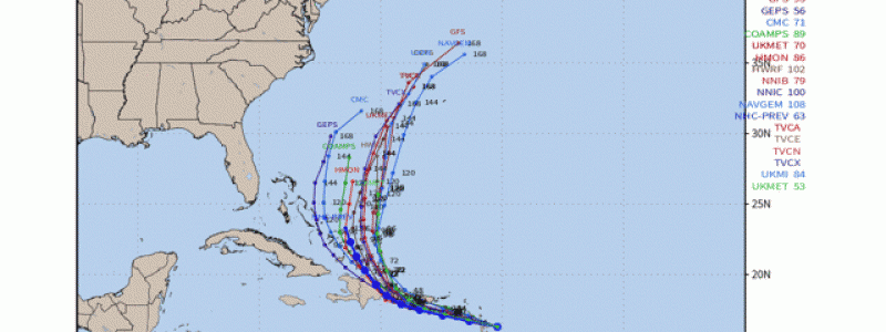
- Model forecasts are in much better agreement that Fiona, as it strengthens, will recurve northward. Below it can be seen from 18z model runs from the 16th, fast-forward three model cycles later to the most recent run (12z), that the consensus of tracks have shifted eastward. This makes sense given the weakness in the western side of the ridge and Fiona’s intensification whereby a stronger cyclone results in a northward shift, versus a weaker system that can “sneak” westward. The latter was more concerning earlier this week, but the former now has higher confidence of occurring. One can easily point out the eastward trend below.
This entire height pattern evolution with Fiona slowly trekking across the Eastern Caribbean created chaos and volatility this week, and this continues to facilitate uncertainty in the near term. As one can see, predictability is typically low when it comes to planetary/large-scale interactions that span thousands of miles, stemming from the Pacific! Throw in tropical systems, and the challenge is certainly difficult to untangle! Fortunately, that’s why we need humans because through logical and rationale reasoning, fundamental training, research and application – meteorologists and forecasters alike provides invaluable input that help influence decision-making!
We’ll be monitoring Fiona over the next week, so stay tuned!
