A Potent Nor’easter Early Next Week?
Lets analyze the z500mb height pattern “snapshot” for early next week using all three major ensembles of the EPS, GEFS, and GEPS showing robust consistency:
- Troughing off the BC coast / NE Pacific
- A shortwave ridge out across the Rockies
- A deep amplitude trough in the East
- Positive heights (blocking) across the Davis Strait/Southern Greenland

These are typically the atmospheric ingredients that we look for to see a large East Coast system to develop, and this is what we could be dealing with come Monday into Tuesday, with lingering effects from the system into Wednesday thanks to both the blocking overhead, or “traffic jam”, that mitigates the storm’s speed and the mid-level “capture” of the surface low.
Below we see two depictions from the deterministic models of the GFS and ECMWF showing the general evolution of the cyclone aloft (500mb) as the trough shifts from the northern Plains through the Great Lakes and looks to “close off” somewhere in the vicinity of the southern New England coast. This has direct implications at the surface because where the mid-upper level trough is closed dictates the overall track of the surface low pressure. A trough that is less amped and “captures” the surface low later vs earlier will dictate then, the overall precipitation type in the Mid-Atlantic and up the I-95 corridor to New England.
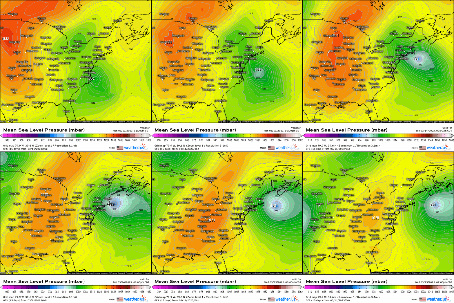
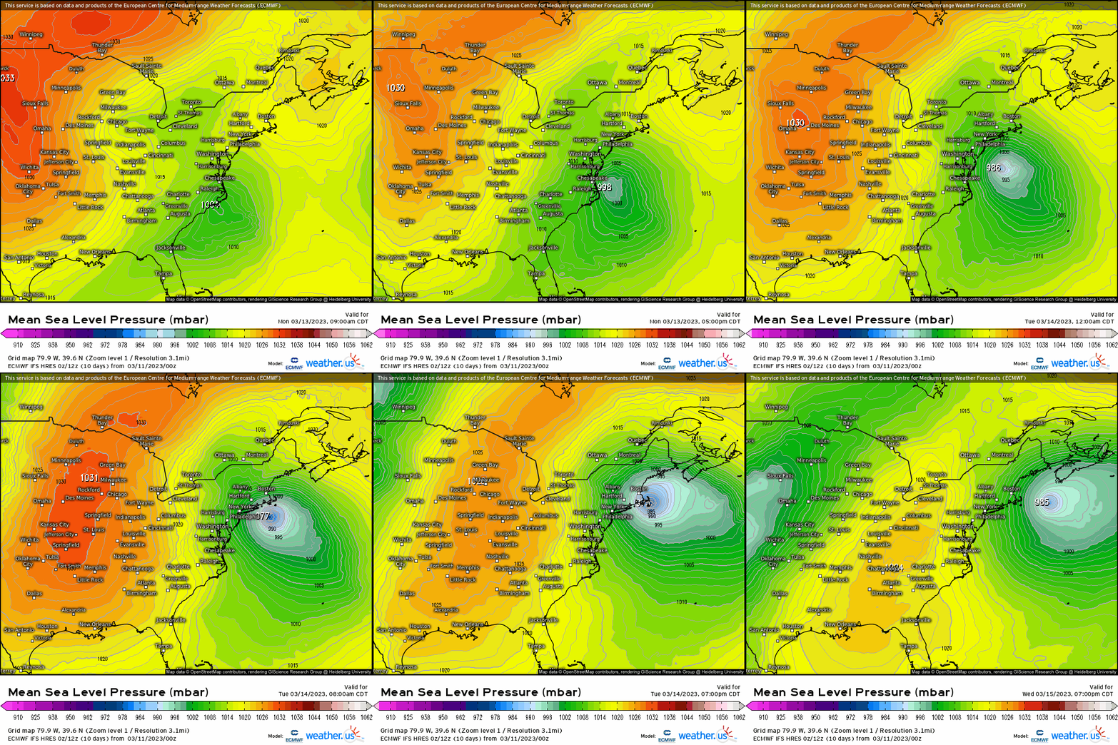
As we analyze further the ECMWF and GFS 500mb evolution, we do see some differences, though they’re overall in pretty good agreement regarding its mid-level and surface progression. The GFS is faster to close off the mid-level trough, thereby allowing for a faster surface low track that “slingshots” into the SNE coast. The ECMWF closes off later, is a little deeper, and slower causing more in the way of snow. Both, however, keep a track that is more inside the “40/70” benchmark, taking a track that hits somewhere in the vicinity of RI and Cape Cod. This “capturing” of the surface low allows the storm to then “crawl” off the SNE coast and stall a bit in conjunction with the blocking, so this can allow not only snow and heavy precipitation to occur, but long-lasting wind fetch and coastal erosion that may result in flooding.
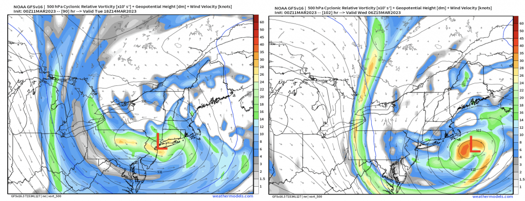
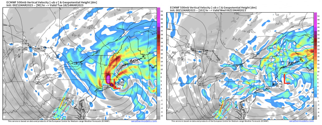
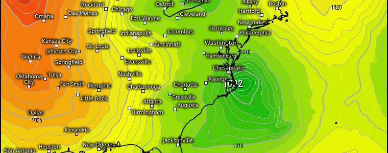
So we put this together and see first the main low develop off the NC coast (E/NE of OBX), then take a a N/NE track toward the coast of RI/Mass. A northeasterly fetch begins (hence nor’easter) early Monday across the Delmarva and works its way up “peaking” through the day Monday before then this wind fetch begins to impact the New England coast. We see the low deepen rapidly through Monday into Tuesday thanks to the dynamics that begin where we have intense forcing for ascent through strong DPVA (differential positive vorticity advection), warm air advection, and moisture advection. The result ends up being heavy snowfall to the north and northwest of the low’s center, where this looks to significantly impact places like NE PA, interior NY (down to the lower Hudson Valley), and across SNE into ME. Now this track certainly has some “play” where it can deviate to the east, which has colder implications because more cold air can advect on the backside.
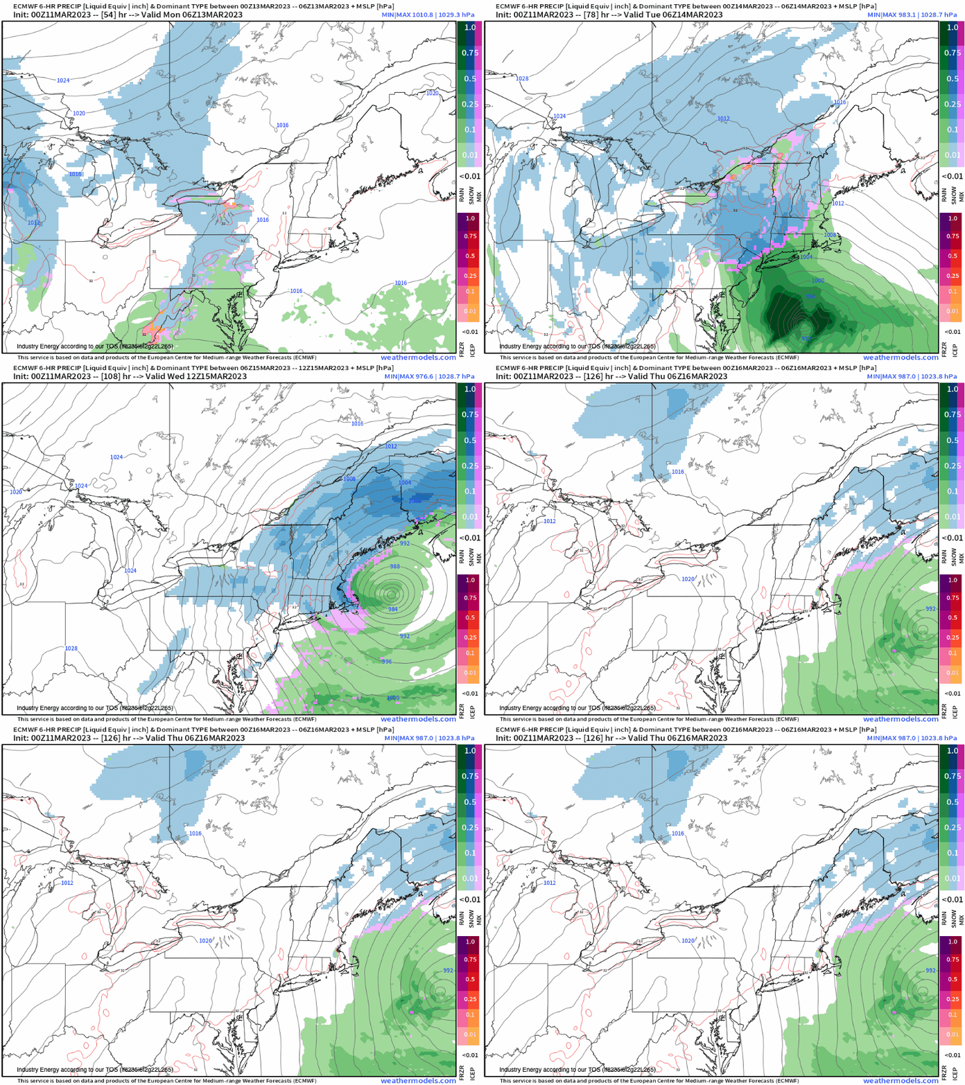
We see the E/NE fetch with strong wind gusts impacting the entire east coast from the Delmarva up to Maine with a potent low developing as it makes its way up the Northeast coast.

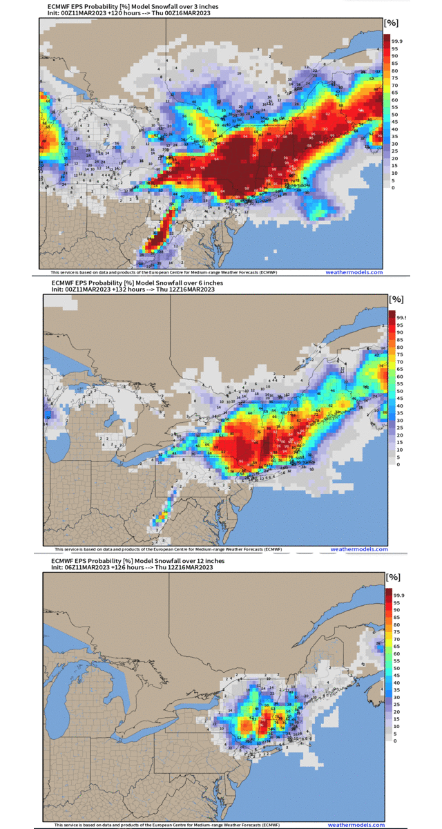
So with snowfall, this is exactly where probabilities come into better use since this is still a fickle setup that a 25-70 mile shift east/west makes a huge difference in either more snow or less! We see here probabilities of > 3”, 6”, and 12”. There’s a robust area where there is general agreement that the “jackpot” will be centered across southern NY into NW CT, W/C Mass., and C/S VT / NH. While higher elevations are surely a “lock” for the higher totals, urbanized areas across SNE and NE surely are in a spot to see the biggest snowfall of the winter season! As you head further south toward the Mid-Atlantic, it’ll be a close call for the big cities especially. Right now, this type of track as we don’t have a strong high pressure that can lock in a stiff NE wind, as the winds leading up to the system are more easterly/southeasterly as you head down the NJ coast. This allows for warmer air to push into the boundary layer, making it hard for snow to make it to the ground. Further south to places like Philly and DC, you’re even more of a disadvantage given the more southerly wind component and lack of cold air initially, so these areas end up on the wetter side.
Stay tuned for updates as we follow along heading into next week!
