A Multi-Day Severe Threat Takes Aim at the Southern US: Day 1
Today kicks off Day 1 of what is most likely to be a multi-day severe threat lasting through the weekend. This threat starts in the southern plains and migrates toward the Gulf Coast states by Sunday. We’ll look at each threat separately in our blogs over the next few days.
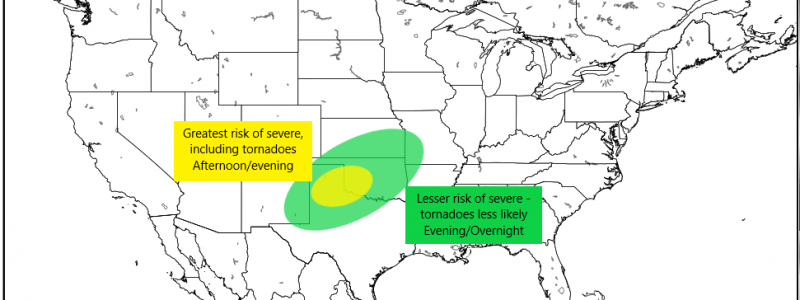
We are focusing on the panhandle of Texas and some of western Oklahoma as the area likely to see the biggest severe threat this afternoon into the evening.
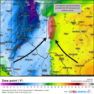
A dryline currently in place over western New Mexico will migrate eastward throughout the day today. Meanwhile, a stalled front will lift northward over the panhandle of Texas and southerly flow will begin advecting warmth and moisture deep into Texas, priming the atmosphere for destabilization.
The surface low driving the southerly flow will remain rather weak, keeping the destabilization on the lower end. We will be somewhat dependent on breaks in the cloud cover and associated daytime heating to aid in destabilization. These breaks in the cloud cover are already showing on satellite around and NE of the Lubbock area. With current temperatures and dew points already in the high 50s and low 60s and rising, I’d say we are on our way.
Later this afternoon, convergence along the dryline should provide enough lift to initiate storms. With lapse rates approaching 8 degrees C per km, shear in the vicinity of 50 kts, and CAPE topping 1500 J/kg, all modes of severe weather will be possible, at least through the evening hours. This means damaging hail, strong winds, and even tornadoes are all possibilities.
These storms could be rather dangerous shortly after initiation. The threat for tornadoes will be a bit time-sensitive, though, and likely only persist through the daylight hours before dissipating with the loss of daytime heating as the boundary layer cools after sunset. Convection will continue with the risk of hail and damaging winds as the storms move into Oklahoma after dark, but the greater tornado threat will remain confined to the Texas panhandle and maybe a small part of western OK. That’s not to say a tornado CAN’T occur with these storms after dark, but that it is much less likely. Regardless, remain weather aware throughout the late afternoon/evening/overnight hours with multiple ways to receive warnings, especially those that will wake you should you need them overnight.
Stay safe!!


