A Messy, Difficult Forecast for the Mid-Atlantic at Week’s End
The south is staring down the possibility of snow late this week. An upper level low currently tracking through the Plains and bringing severe weather to Texas today will make for a very complicated forecast across the south/mid-Atlantic in the upcoming days.
Lower latitude states need a few ingredients for a solid snow forecast:
- Cold air. This cold air needs to already be in place or, at the very least, be rushing south quickly.
- Enough moisture behind the front to reach the cold sector. If the atmosphere is too dry where it is cold enough for snow, you’re out of luck.
- A weaker low close to the Gulf Coast. A strong low will feed too much warm air in aloft, bringing the temperatures aloft above freezing and setting the stage for freezing rain or sleet instead of snow. A low too far north from the Gulf leaves key areas in the warm sector with little hope of cooling enough for snow to be possible at the surface.
So let’s take a look at the ingredients and see what we have to work with.
Cold Air
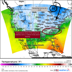
While we have a strong high to the north, it is a bit TOO far north to do us much good here. Any air that travels southward will have a great distance to cross and will modify as it moves south. Seeing as how it has to move over areas that are barely below freezing, there’s a good chance that by the time it reaches the areas in question, it won’t be cold enough any longer to make a difference. Also, temperatures ahead of the system are relatively warm, with the exception of the elevations. Most locations are at or above freezing. With no true cold air incoming, this is unlikely to change much over the course of the storm. A storm can create its own cold air through evaporation – moisture falling into dry air aloft and evaporating, cooling the air around it- but you’d need a decent layer of dry air aloft and enough moisture above that for this to occur.
Moisture
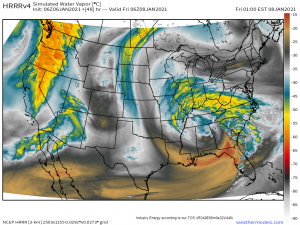
This is one requirement we can definitely check off of our list. A large area of moisture exists with dry air locked well to the south and west. It’s possible that the dry air could work in a bit toward the end of the storm through advection in the form of a “dry slot,” especially on the southeastern side of the low. However, enough moisture exists north of the center of low pressure to provide continuous, widespread precipitation.
Location of the Low
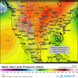
This requirement poses a bit of a problem. Though the low is pretty far south, it may not be quite far enough. The location of the low places the areas in question (Tennessee, North Carolina) sort of half in and half out of the cold sector. Though the low is decently weak, some warm air advection will still happen on the east side of the center. With temperatures borderline beforehand and no true cold air incoming, this could wreck chances for any real, accumulating snow and point toward more of a mix or cold rain.
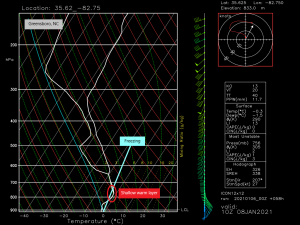
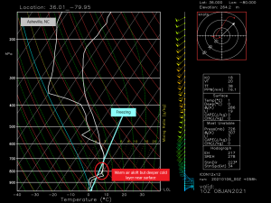
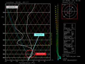
Looking at the soundings I’ve included above, we see evidence of warm air advection aloft.
Most noticeable would be in the sounding for Gastonia, NC. There we see a relatively deep warm layer with a very shallow layer below freezing at the surface. Any snow that falls will melt in the warm layer and then possibly, if it has time, refreeze on the way to the surface. Here we could see either just a plain, cold rain or maybe some sort of mix of sleet and freezing rain with a few brave snowflakes thrown in.
Both Asheville and Greensboro have relatively shallow warm layers (further north/west away from the center of the low). Greensboro sees a more shallow layer of cold air near the surface than Asheville, however, meaning their precip will likely be a mix of sleet and snow. Asheville may see some mixing, but will likely stay mostly snow, especially on the back side of the system.
This is a tough forecast for sure. The only place I really see this being a slam dunk for snow is the Appalachians of North Carolina where it will not only be cold enough, but a favorable easterly flow will trigger an upslope event, lifting the moisture into the cool environment of the mountains and enhancing totals.
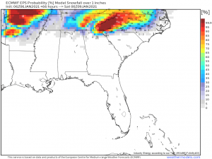
Probabilities tend to agree. The best chance for solid, accumulating snow is by far over the mountains. Once the low passes off to the east and the areas in question are entirely in the cold sector, any moisture left over could then be snow should the temperatures be able to fall enough before dry air moves in, anyway. Greatest chances for this then would be north/northwestern North Carolina and southern Virginia, where temperatures will already be favorable.
In summary: the only area pretty much guaranteed snow is the Appalachians. Other than that, there is a decent chance of some accumulating snow in far north North Carolina/south Virginia where warm air aloft won’t be as big of a problem. The elevations of Tennessee (Smokies, Plateau) also have good chances while the valley areas (Knoxville) will have the same mixing issues as parts of North Carolina due to borderline temperatures and no true source of cold air.
Well, that was a lot to write! We will, of course, update y’all as needed if things change between now and the onset of the storm late tomorrow.
Have a wonderful day!!
