A Large-Scale Natural Phenomenon Took Place This Week: A Sudden Stratospheric Warming!
Earlier this week, we officially had declared an official Sudden Stratospheric Warming. By definition, this is where the zonal mean winds at 10mb (> 12 miles above Earth’s surface) reverse completely from westerlies to easterlies. This embodies a significant disruption to the vortex through rossby waves (i.e. troughs) that basically can manifest strong destabilization to the vortex by impacting it through unique energy dispersions. They can travel into the stratosphere and “break” (think of a cresting wave on a beach), thereby creating “attacks” on the vortex’s structure depending upon exactly how strong they may be and duration. Not every single time this instance happens leads to an automatic disruption, but that is the general gist of how this occurs in a very simplistic explanation.
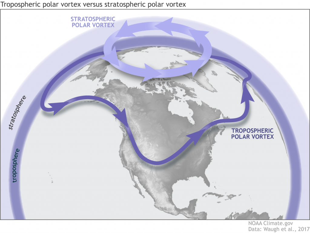
Now, don’t get this confused with the tropospheric polar vortex, which is a permanent atmospheric entity that becomes most prevalent during the winter of course as when we see the strongest dipole of arctic air in the poles, and warm air toward the equator. This is where the arctic air is confined toward, encased by the polar jet. We always see arctic outbreaks “bleed” into the middle latitudes whenever the polar jet is forced southward. We also tend to see large undulations as cold, arctic air can spill southward as the polar jet simply divides the cold air from the warm air. Again, this is in the troposphere where our weather happens! The stratospheric polar vortex, however, is a semi-permanent feature and is separate from the tropospheric polar vortex. It develops late fall as we see the seasons change toward fall and winter once the Northern Hemisphere is tilted away from the sun. This is when it begins to generally strengthen during winter, and can either remain strong through the winter months or endure disruptions from below. Then by Spring, it slowly weakens becoming essentially non-existent where the zonal mean winds are completely reversed. We repeat this cycle every year. We see the differences portrayed very nicely below via a nicely written blog from the NWS.
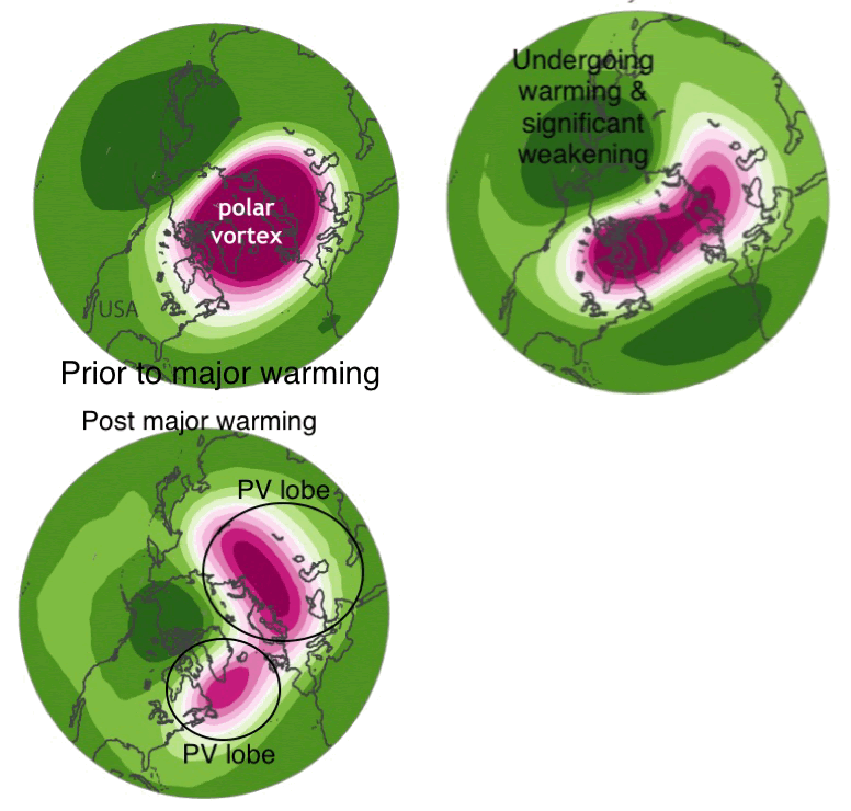
Through animated GIF’s below, I’ll explain the fascinating phenomenon that transpired earlier this week. Using 10mb geopotential heights where pink represents the stratospheric polar vortex and the green represents higher pressures. In three stages:
- Initial coherent vortex over the North Pole prior to a major warming event.
- The vortex undergoes major warming & disruption, where it’s enduring stretching and weakening.
- The end result of a completed major warming event.
I should emphasize that just because we see a split at 10mb (~ 30mi high), it doesn’t necessarily mean that the bottom portion of the vortex is completely altered. In fact, it can remain intact, though still is weakened relative to its state prior to a major warming event. Furthermore, research is still ongoing in exactly how following these unique events, what happens in the troposphere even though we have sufficient evidence & confidence through case studies of prior events of what may follow. Not all SSW’s are the same!
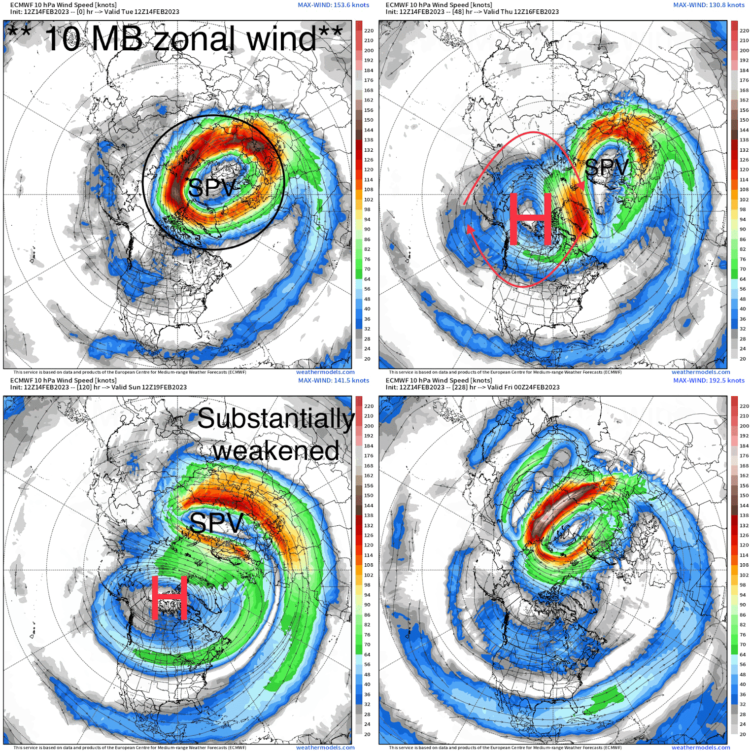
Now, lets take what happened this week by looking at the stratosphere 10mb winds via ECMWF. I did a “play-by-play” depiction of what happened just prior to the major warming event, during, and the forecast to follow. The vortex, initially coherent and quite circular, gets shifted and deformed at 10mb via large-scale ridging (high pressure). Below, tropospheric waves helped facilitate that large high pressure, and in turn caused a large disruption. We then see what was initially a strong, cyclonic vortex, become significantly altered and weakened. It also was shifted off kilter (something steady-state that gets knocked off like a spinning top will lose control). Research does show there’s some correlation between splits, and unsettled / cold weather impacting Europe while the U.S. is much less certain. Obviously do not automatically think this is the infamous “Beast From The East” (2018), because again not every single SSW event is the same!
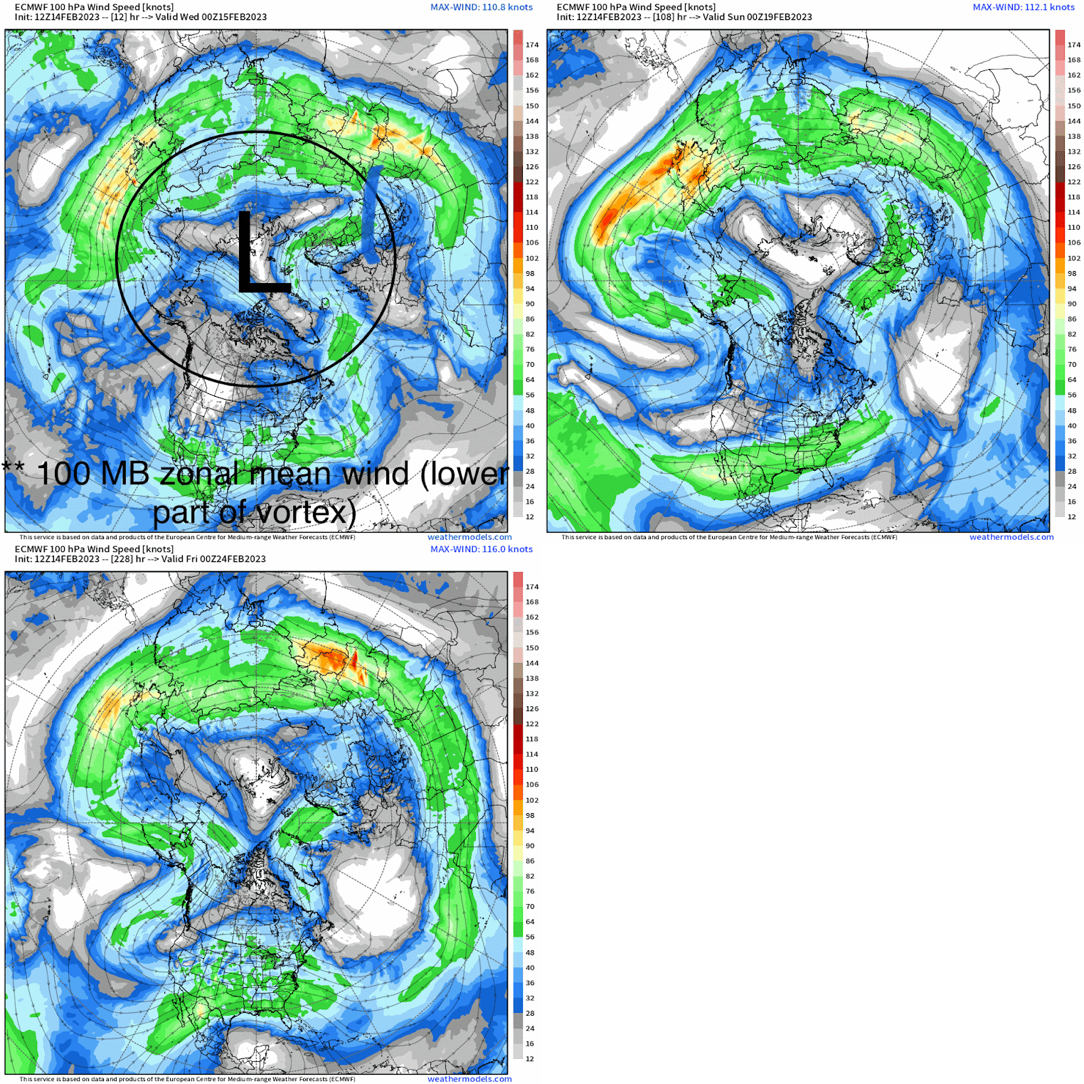
Now, going back to the original point of 10mb (top of stratosphere) versus the lower portions of it (100mb). Here, we actually see the vortex still intact, though more undulations as we progress deeper into February indicating some weakening. Again, we don’t know how this specific event pans out in terms of coupling between the stratosphere and troposphere. What could happen is that above 100mb, the vortex is completely disrupted and weakened; however, below, the tropospheric polar vortex is strong and keeps the arctic air still confined toward the North pole. On the contrary, we can see what many typically think initially is that we do see this successfully trickle down into the troposphere causing dramatic impacts like high-latitude blocking. This would result in arctic air masses spilling southward and subsequently causing much more in the way of wintry weather.
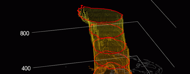
Now, one of my all-time favorite websites (huge shoutout to Zachary D. Lawrence) to view certain parameters pertaining to the stratosphere can be accessed in the hyperlink. There’s nothing more aesthetically appealing then observing a 3D visualization of a process such as this! Below, we go from just prior to the major disruption, to a complete split above 50mb (from the 14th to this weekend). We see the reversal of the 10mb winds and how the vortex responds, but what is also important to note is that as we reach the bottom of the vortex, it’s still intact though not as much as it was prior to the warming (verbatim).
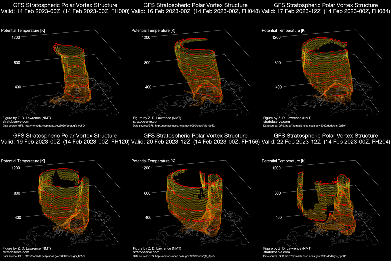
Above was all an explanation to show, explain, and reveal how a major SSW event transpires since we had one occur this week! It’s nearly unfathomable how a process such as this can occur! The atmosphere and all that is connected truly is awe-inspiring!
Now, there are hints (further delved into in Saturday’s blog) that we may see high-latitude blocking (i.e. -NAO / -AO) occur in the troposphere as we progress into March. I also should note that the impacts, if successful in that the stratosphere “links” to the troposphere, typically takes weeks for our sensible weather patterns to be impacted (usually up to 60 days post disruption). Again, I want to emphasize is that there is a great deal of uncertainty and variation in what exactly happens following these events despite some correlation and research. The latter, though, basically represents the fluid that is the atmosphere because it’s always yielding uncertainties and will continue to do so, which will render unrelenting scientific findings!


