A Dangerous Day Ahead
Confidence has increased in today being a highly impactful severe weather day with all hazards possible.

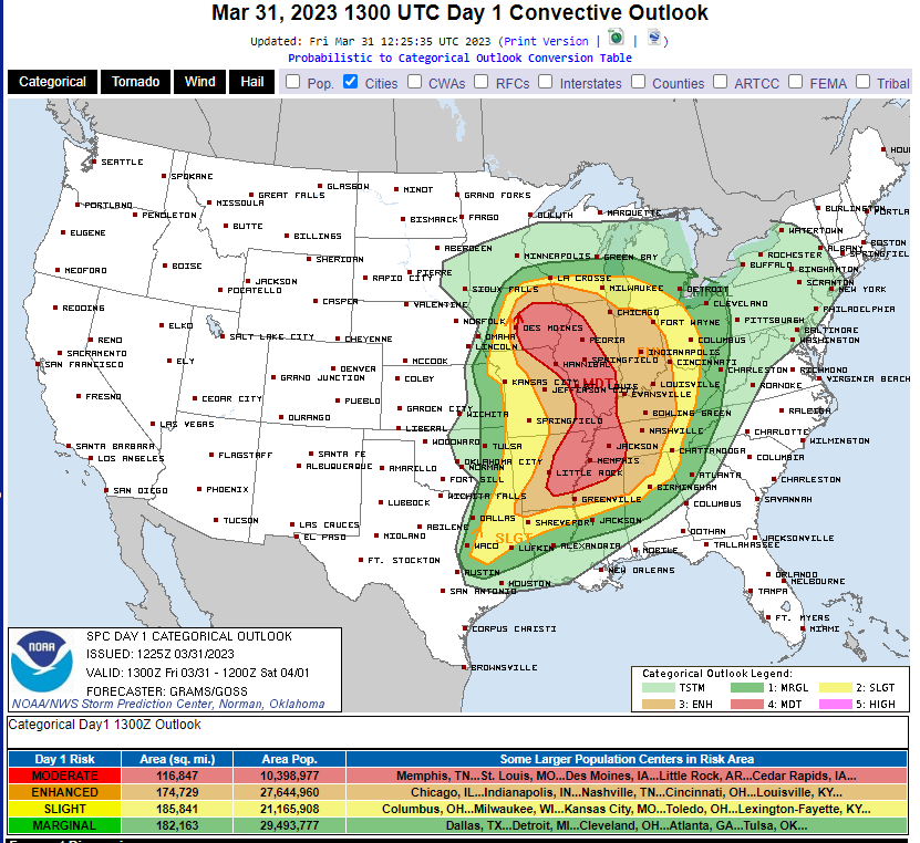
The moderate risk has been expanded this morning and now includes a large portion of the Mid-Mississippi River Valley from the Wisconsin border down through northern Mississippi.
What does this mean? Generally, it means those inside this defined risk area have the highest probability of experiencing today’s most potent storms.
However, it’s important to point out that anyone in any of the defined areas on the map above has a chance to receive severe weather today. Don’t let your guard down simply because you’re in the yellow (slight) or green (marginal). Storms don’t follow boundaries drawn on maps. Severe weather can still occur in these areas, it’s just possible that it will be scattered or isolated rather than widespread.
Armando wrote an in-depth blog on this threat yesterday, so this morning I’m merely going to update the timing and hazards expected.

Timing:
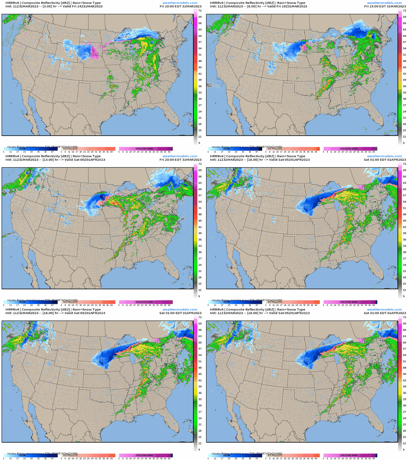
Storms should begin to fire in the early afternoon hours. At the moment, it seems that two rounds of storms are possible for many in today’s risk areas.
The first round may be especially potent as discrete (single) supercells form in the open warm sector. Strong, long-track tornadoes are possible from these cells as is large hail.
The second round will come ahead of the cold front itself. This may also start off discrete, but quickly grow upscale into a line. This line will eventually overtake the discrete cells in the open warm sector and become the primary mode of convection. Damaging winds, some in excess of 75 mph, will become the primary hazard. However, tornadoes will remain possible with any supercells embedded in the line itself.
The threat for severe storms will persist into the overnight hours, weakening some with eastward extent in the early morning hours.

Hazards:
With a strong low-level jet and a roaring mid-level jet in place, this will be a highly sheared environment. Add to that plenty of available instability and lift, and we have an environment capable of very dangerous weather.
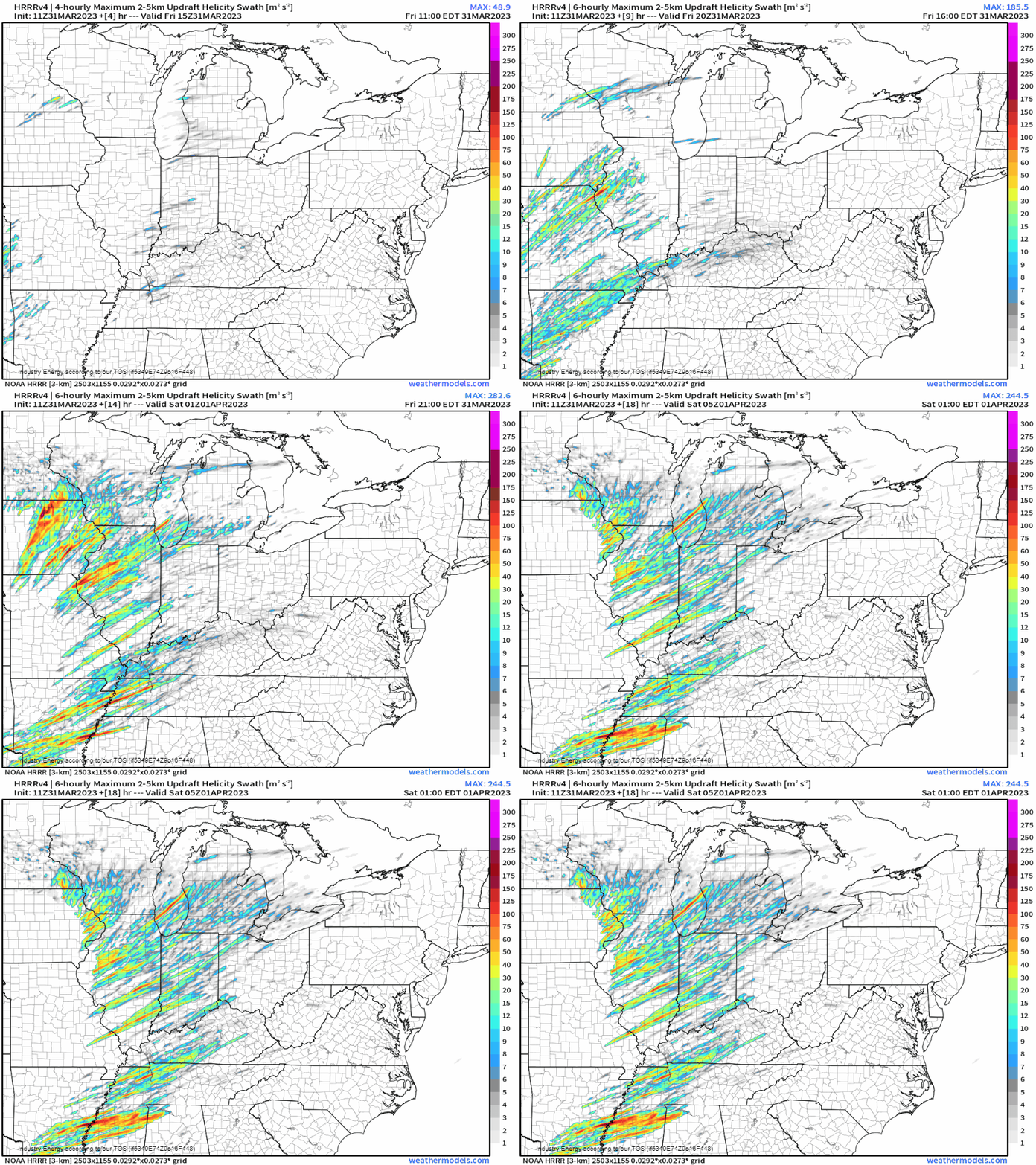
The map above is the modeled updraft helicity swaths. This should not be taken verbatim in location nor as confirmed tornado tracks. Updraft helicity shows us how much potential rotation a modeled storm may have (a supercell). Whether or not it produces a tornado is dependent on other variables as well.
But, as we can see, today’s storms will have plenty of rotation potential. This points towards supercells, as already mentioned. Supercells will be capable of large hail, damaging wind, and, yes, a few tornadoes. Tornadoes that form from the aforementioned supercells may be strong (EF-2+) and long-tracked.
You’ll notice the UH swaths decrease in intensity with eastward extent. At this point, convection will have evolved into a line and damaging winds will become the main hazard. However, as mentioned above, a tornado or two remains possible embedded in the line.
Take Action:
- A large part of the Mississippi River Valley and surrounding regions is under threat of severe weather today.
- Two rounds of storms are possible for many in the defined risk area. Don’t let your guard down after the first round.
- Everyone needs to have multiple ways to receive warnings. A NOAA weather radio with battery back-up should be your primary source and at least one other (weather app, wireless EMA, radio, etc).
- DO NOT rely on outdoor sirens as a primary warning source. They are not meant to be heard indoors and also may not sound in some cases.
- Charge your devices and keep them charged. There is a widespread damaging wind threat and power may go out for multiple hours.
- Storms will be moving very quickly. It is important to take action immediately if a warning is issued.
- Make sure your safe space is ready to go. This should be on the lowest floor of your home in the most interior location you can find. Put as many walls between you and the outside as possible. Everyone needs hard-sole shoes and a helmet.
- Due to the potential intensity of the damaging wind threat, shelter for a severe thunderstorm warning as you would for a tornado warning.
- Warn your friends, warn your family. Increase awareness and preparedness as much as possible ahead of this event so no one is caught off guard.
Since this severe threat covers such a large area, it’s nearly impossible for me to cover everyone’s area specifically. Check out your local NWS forecast and also your local broadcast meteorologists’ coverage for specific times and threats. They’ve got your back today.
Stay safe!


