A Chance for Snow for Parts of the Mid-Atlantic Tonight
Good morning! Well, we have another active weather day in what has already been an eventful week… and it’s only Wednesday.
A few things are going on across the country. First, we have the atmospheric river event bringing crazy rain and snow totals to the west coast. I’m not going to spend any time on this today since Jacob wrote an extremely detailed blog analyzing this event yesterday. Give it a read if you haven’t already!
Next, we have a system moving east this morning that has the potential to bring some snow to parts of the mid-Atlantic. About 5-7 days ago or so, you may have read posts on social media that heralded a hurricane-strength system that was going to bring crazy snow totals to the region. Yeah, not happening.
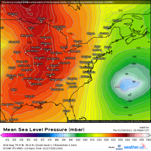
The system will indeed strengthen impressively.. but not until it’s well offshore.
There are a few reasons why this won’t end up being the monster the models suggested it would be almost a week ago. We just looked at the first one.
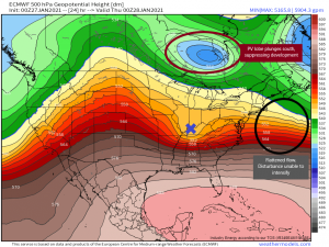
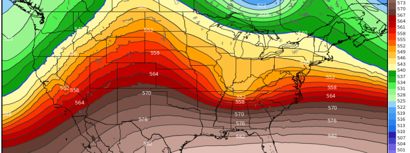
The reason it won’t strengthen until it exits east is two-fold. First: Monday’s system took it’s time exiting. It’s slow shuffle off to the east did not leave much space between disturbances and resulted in a “flattened” flow, leaving the incoming disturbance no ability to dig down and intensify. Second: A polar vortex lobe is in play. It’s southward progression suppressed the system’s development and worked with the flattened flow to keep it from intensifying. What we are left with then is a rather weak, here-and-gone rain to snow (non)event.
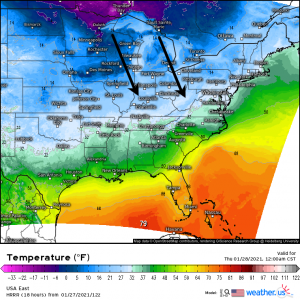
So if we aren’t seeing a blockbuster storm, what are we expecting? Well, antecedent temperatures right now are warm. A large portion of the mid-Atlantic is expected to rise into the 50’s today so this event will begin as rain.
Thanks to the aforementioned polar vortex lobe, we will have cold air rushing south quickly as the low passes. This will encourage a change-over to snow from west to east this evening and overnight.
As we know from past blogs, we need a few ingredients for a southern snow storm: thermal support, a weak low close to the Gulf, and moisture. We’ve already established that there will be cold air. The location of the low is a little less than ideal. Though it is weak, cutting down on the warm air advection from the south, it’s a bit far north. The cold air won’t be able to rush in until after the low passes meaning whatever snow there will be will dependent on the remaining, back-side moisture, which tends to be limited in these systems due to location.
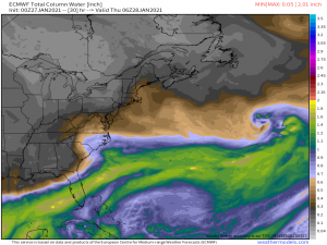
About that moisture:
Not a whole lot of it available. The deep moisture stays locked to the south, leaving this system with very little to work with. It does, however, seem to be able to advect just enough near the center that if we can get decent lift from the low’s vorticity, we may be able to see a few heavy bursts over central North Carolina and southern Virginia.
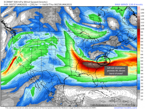
Divergence aloft associated with the left exit region of the jet streak could give us the boost we need to send the moisture up and squeeze some snow out of it. Surface temperatures should be near/below freezing at this time so, with enough lift, this could definitely be a decent burst of snow. Now, snow falling and snow sticking are two different things. As mentioned earlier, antecedent temperatures are warm so surfaces such as pavement will need to cool a bit before any accumulation can happen. We are more likely to see accumulation on grassy areas and elevated surfaced at first. If we can manage decent snowfall rates, we could cool the pavement enough for a slushy coating.
This system will be a fast mover so accumulation really depends on how fast that change over from rain to snow happens plus how much snow we can squeeze out of that small window where we have adequate lift.
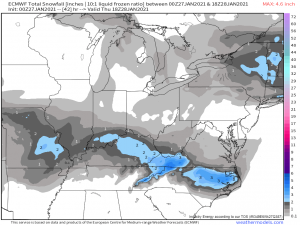
I’ve chosen to use the ECMWF here since it’s taking the middle ground with accumulations. Obviously the Appalachians will see the highest totals because, say it with me: orographic lifting! We know how that works by now. But we also see the potential on this map for that left exit divergence to really deliver for central North Carolina. To see the three inches suggested here though, we are going to need some heavy snowfall rates to overcome the warm ground temperatures. Is it possible? Certainly, if we have the lift for long enough. Is it likely? Well, there is certainly the potential for some heavy banding here to overperform. That said, there is also the potential for it to severely underperform or completely bust. If we DON’T end up with adequate lift, accumulation may be nearly non-existent as we don’t have much moisture to work with in the first place.
So, in summary, expect rain to snow today and tonight for the mid-Atlantic. Totals will be highest in the Appalachians, as usual, but there is potential for a quick burst of fairly heavy snow for Central North Carolina as well. I know a lot of NC snow lovers are hoping this pans out and I sincerely hope y’all get your wish. As for me, I’ll be lamenting the loss of yesterdays temperatures in the upper 60’s and hibernating til spring.
Have a wonderful day, y’all!
