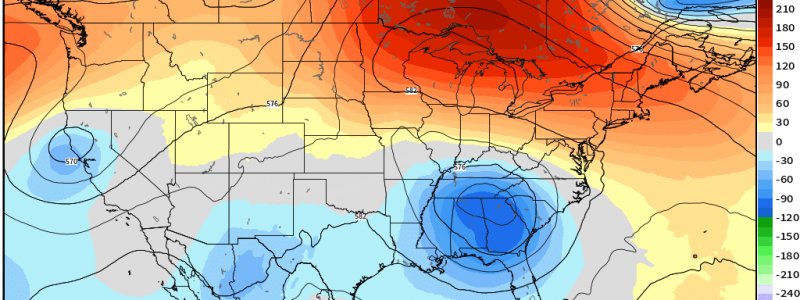
Blocked: Your Memorial Day Weekend Forecast
Memorial Day weekend is typically seen as the official start of the summer season. Many schools are out, weather is generally shifting into that summer warmth, and an extra day off work just begs for those weekend-long celebrations. As many of these celebrations occur outdoors, the weather has the power to make or break Memorial Day weekend.
What does the forecast hold for our long weekend? Let’s check it out!
Saturday:
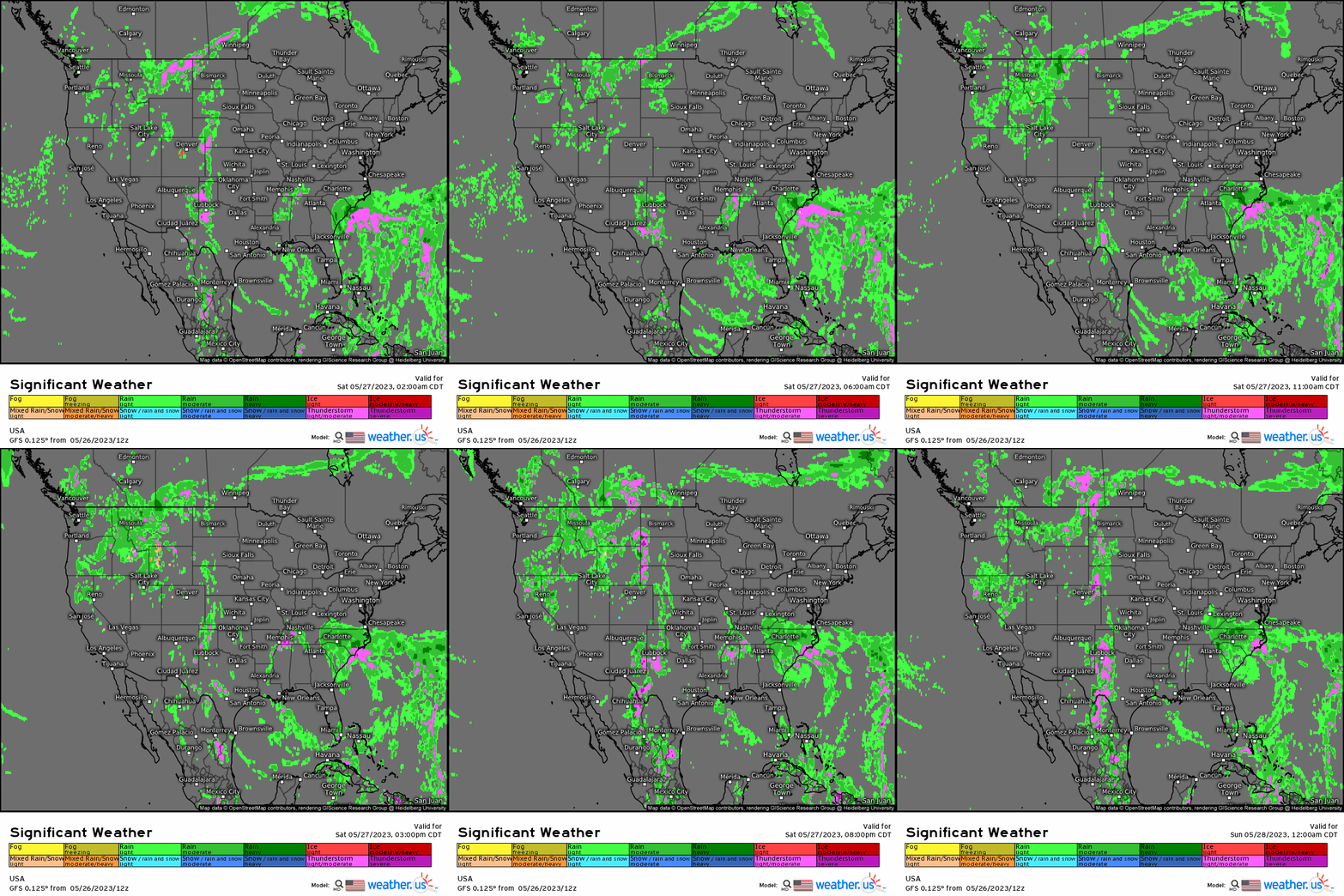
This will be a weekend of the “haves” and “have-nots”.
Our significant weather loop above makes it clear who will be in the “have-not” category.
- A coastal low in the Southeast will keep conditions soggy, breezy, and cooler than average. Flash flooding could become a real concern, especially in the Carolinas, as heavy rain persists for mulitple days. Additionally, rough seas and rip currents are expected as this low swirls onshore, making any plans to go boating or swimming a no-go.
- Moisture streaming into the High Plains will set the stage for a severe thunderstorm risk. Hail and damaging winds will be the main threat, but a tornado or two is possible.
- The Northwest/Great Basin region will remain soggy as an upper-level low and anomalous moisture sits over the region. Due to the sluggish nature of the low and anomalous moisture available, some flash flooding is possible.
As far as the “haves” go:
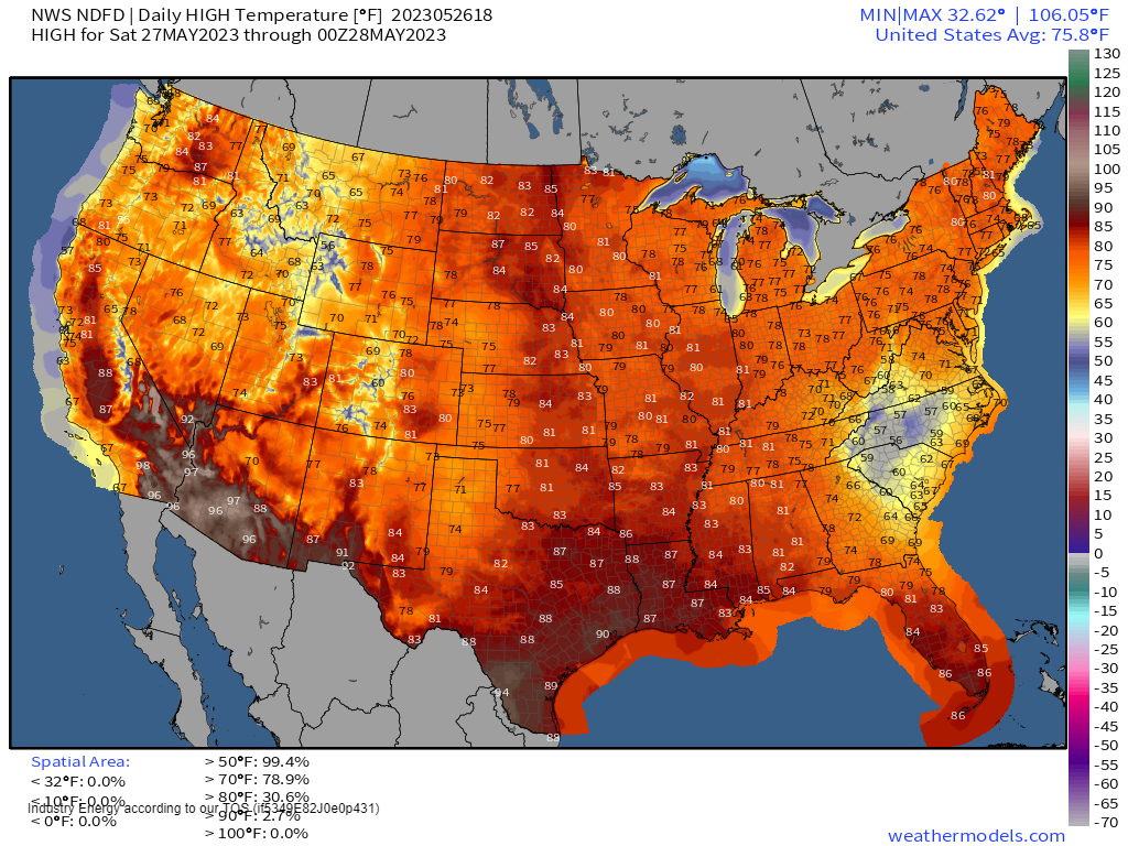
- As our Rex Block pattern matures, the ridging present over the Mid/Upper Mississippi Valley region, the Great Lakes, and the Northeast is evident by the lack of unsettled weather in the loop above. Above average temperatures and pleasant, sunny days will reign here.
Your high temperature snapshot for Saturday:
Sunday:
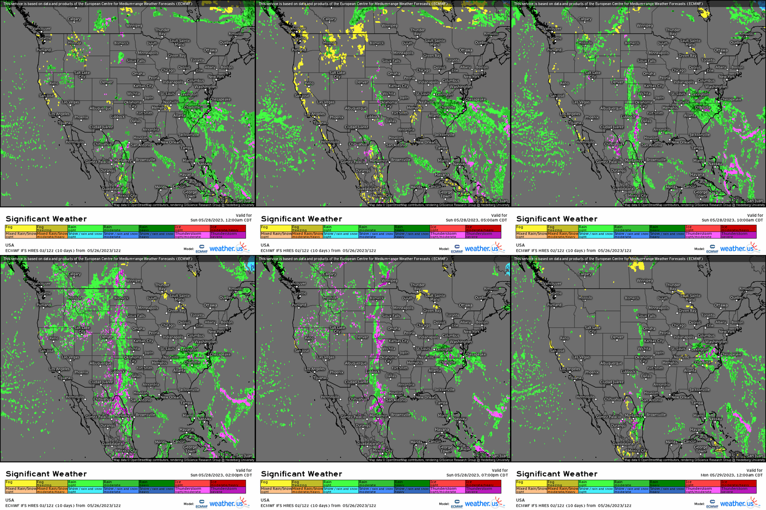
Unfortunately for our have-nots, the pattern will remain much the same for Sunday as our Rex Block dominates the flow.
- The coastal low will continue to inundate the Southeast with rain, wind, a chance of flash flooding, and less than ideal beach conditions.
- The High Plains will have another, somewhat more limited shot at severe weather. The threats will remain the same as Saturday: damaging winds and hail, with a non-zero tornado chance.
- As the Rex Block persists over the Eastern US, the upper-level low in place over the interior Northwest/Great Basin region will remain there. Showers and storms are again possible as is isolated flash flooding.
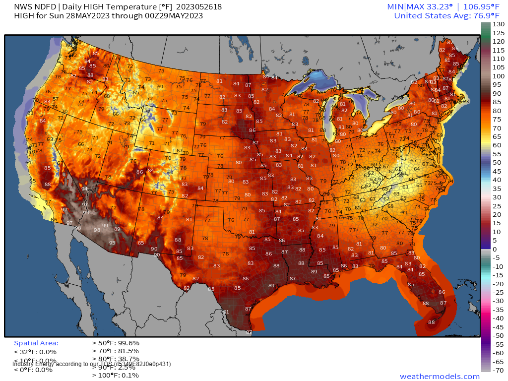
I’ve already mentioned that the Rex Block will remain firmly in place, so it stands to reason that the gorgeous weather courtesy of the ridging portion of the block will also persist. Another beautiful day is in store for the Mid/Upper Mississippi Valley, the Great Lakes, and the Northeast.
Your high temperature snapshot for Sunday:
Monday:
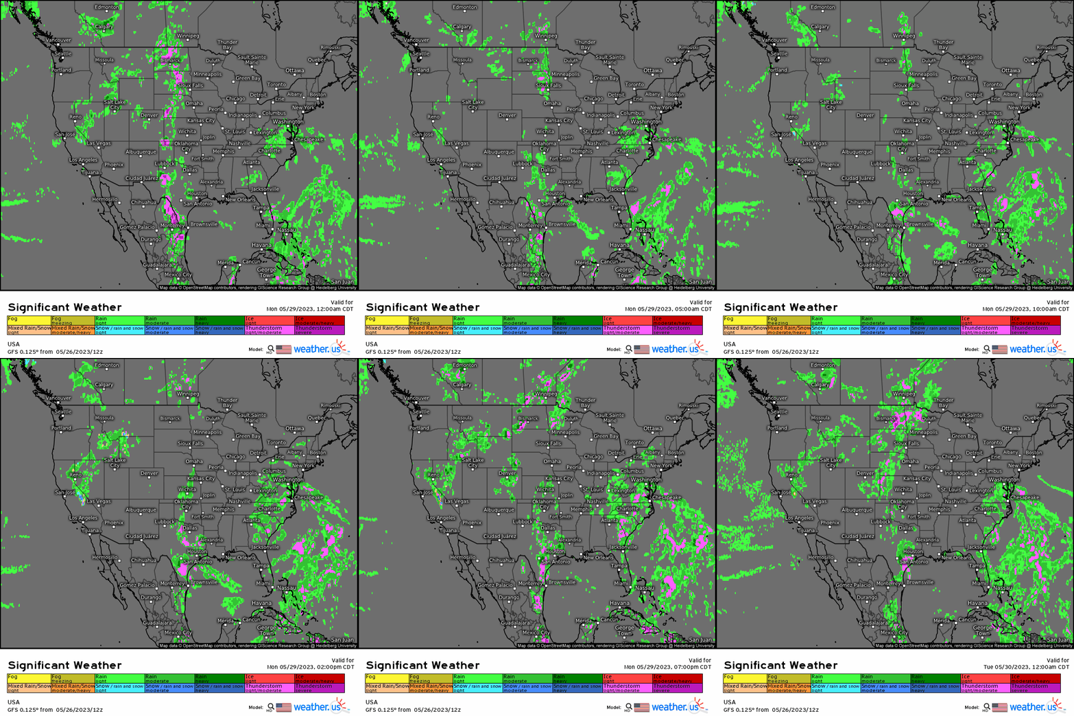
I’m beginning to sound like a broken record here, but I fear more of the same is possible for Monday.
- The Rex Block persists over the Eastern US. The Southeast remains soggy while the northern portion of the Eastern US remains dry and warm.
- The Western upper-level low will continue wandering the interior West, sparking showers and storms as moisture keeps streaming north into the region.
- Some severe weather may remain possible across the High Plains, but confidence is lower than on Saturday and Sunday at the moment.
Your high temperature snapshot for Monday:
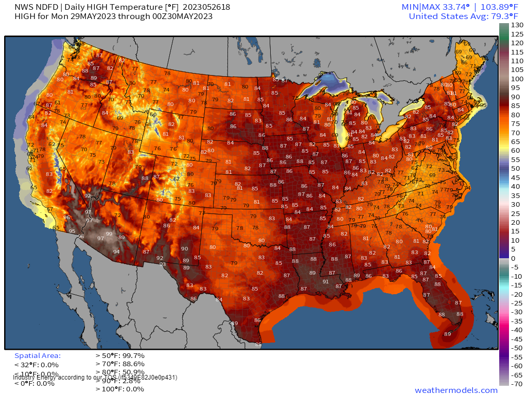
The gist of this holiday weekend forecast is this: if you have crappy weather on Saturday, expect it to remain relatively lousy for the entire long weekend. If you’re lucky enough to be under the influence of the ridging portion of this nasty block, you’ll keep your fabulous weather for the entire weekend.
Our Rex Block will slowly start to unravel toward the middle of next week. As for what’s ahead, we’ll take a look at that when we come back on Tuesday.
If you’re looking for a more in depth forecast for your area, visit the city-specific products available on the weather.us page or the City Charts section of weathermodels.com!


