Spring Is Back, And So Is Severe Weather
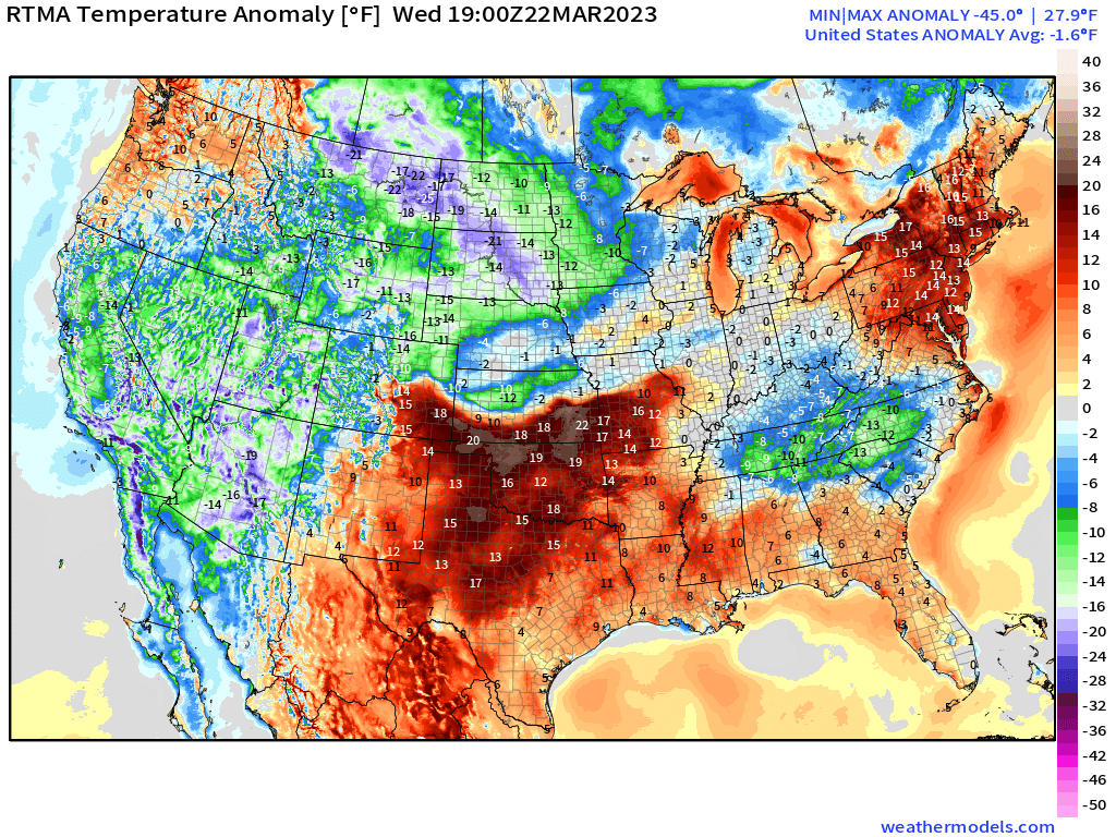
Now that the well-below average temperatures have (for the most part) vacated the Eastern US, Spring is about to return with all the subtlety of the Kool-Aid Man crashing through the nearest wall.
Both temperatures and moisture are increasing across the Southern Plains and Mid-South today ahead of our next big weathermaker, as evidenced by the map above.
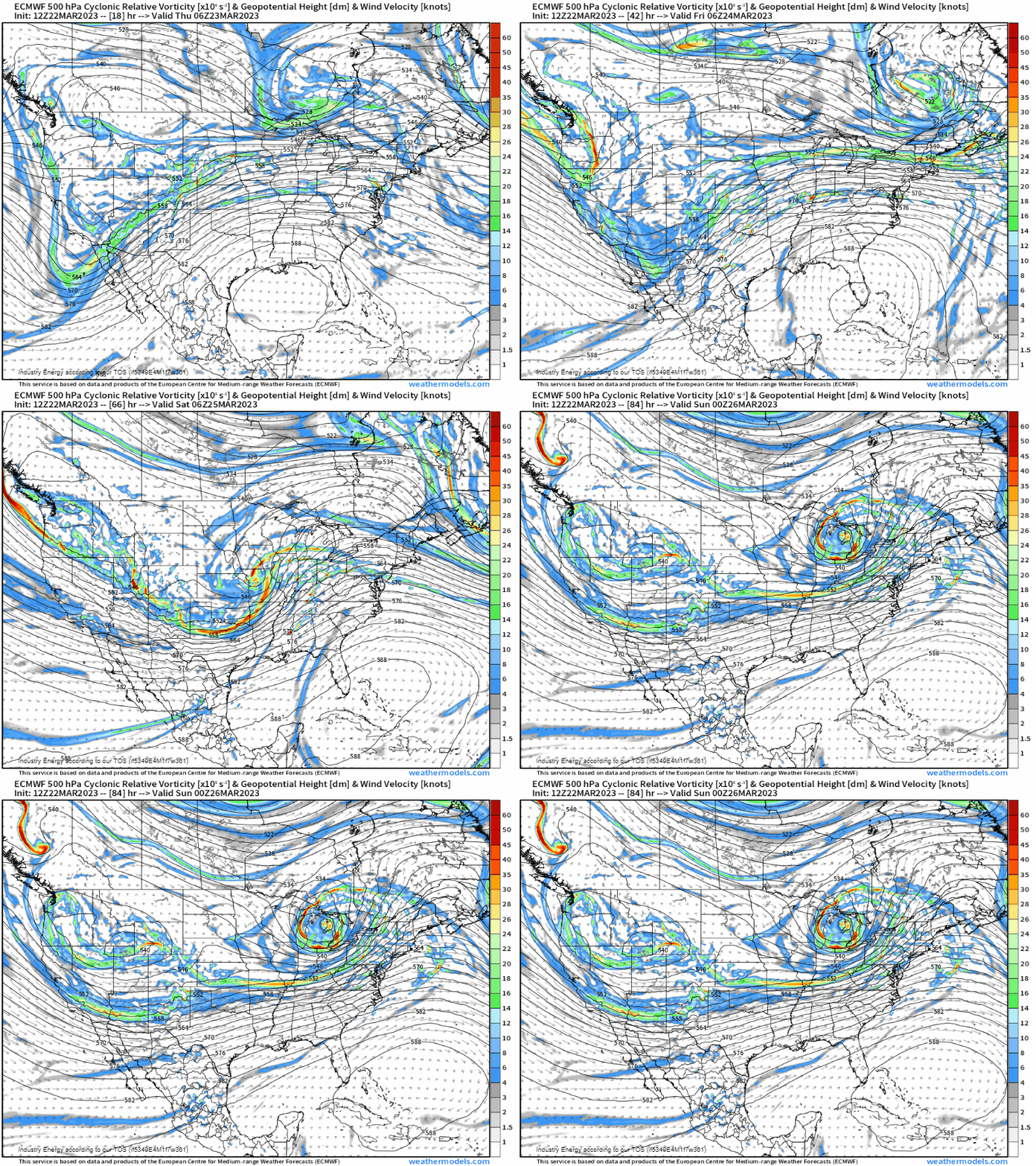
The trough associated with the powerful low that brought wild weather to California yesterday has begun rolling eastward. An embedded shortwave will help to spark a severe threat that begins Thursday and may become much more potent on Friday. Let’s look at each day individually.
Thursday

As the aforementioned trough descends the Rockies tomorrow, a weak surface low will begin to materialize as surface cyclogenesis takes place late in the day. This places parts of Central Texas and Central Oklahoma under the gun, so to speak.
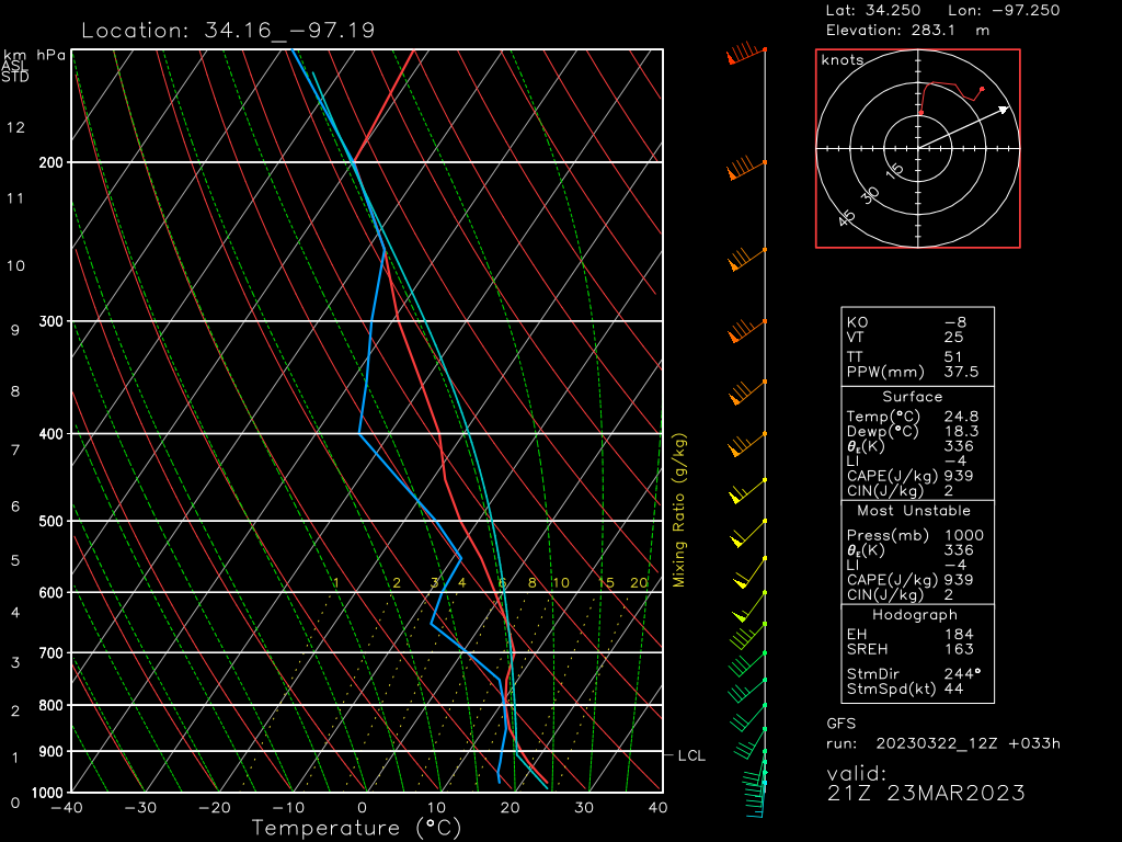
The surface low is forecast to remain weak through Thursday – a factor that will effectively limit the potential hazards seen from any storms that form.
With no real strengthening in store for the low through late Thursday, low level shear – both speed and directional – will remain lackluster. Deep layer shear will be adequate to organize storms and allow for a few supercells as they fire off the dryline in the afternoon. However, nearly unidirectional low-level shear and no meaningful increase in speed with height through the lower levels will greatly limit the tornado potential. That’s not to say that a tornado or two isn’t possible, just that the risk is rather low.
Steep lapse rates and decent elevated CAPE will allow for the main hazard to be large (or potentially very large) hail.
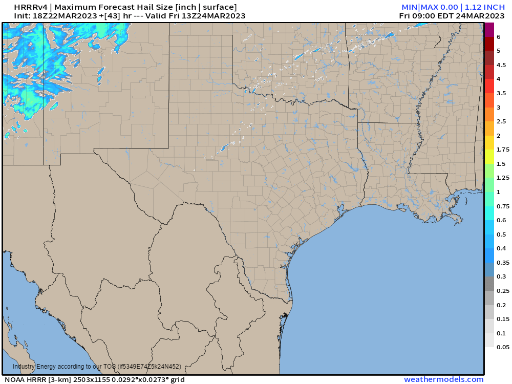
Damaging winds within some of the stronger storms are a possibility as well. But for now, the biggest threat from Thursday’s storms seems to be hail.
That will not, however, be the case on Friday.
Friday
The weak low that is expected to limit severe potential for Thursday will begin to deepen fairly rapidly by Friday.
With a strong jet streak aloft and an intensifying LLJ, shear will not be a problem this time around.
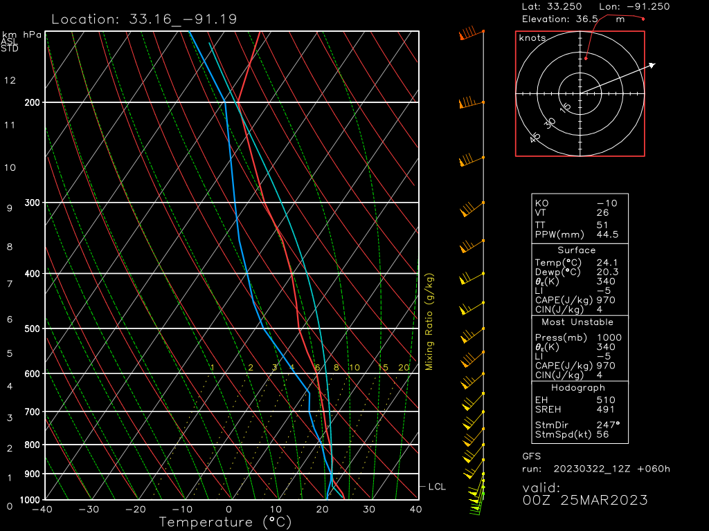
Forecasted soundings depict a very strong LLJ in place ahead of the storms Friday late afternoon/evening. Directional sheer modeled isn’t the best we’ve ever seen, but with winds veering from SSW at the surface to WSW aloft, it should be adequate for a tornado threat. Discrete supercells are expected initially, and it’s during this period that the threat of strong tornadoes will be at its highest.
Damaging winds will also be a concern, especially as convection evolves into a more linear mode in the evening hours.

The current thinking is that storms will begin to intensify in the early afternoon hours over Eastern Texas. As they move east, they’ll encounter a more unstable atmosphere over Louisiana, Arkansas, Mississippi, and Western Tennessee. It is here where the “highest quality” ingredients will be found and the severe threat is expected to be maximized.
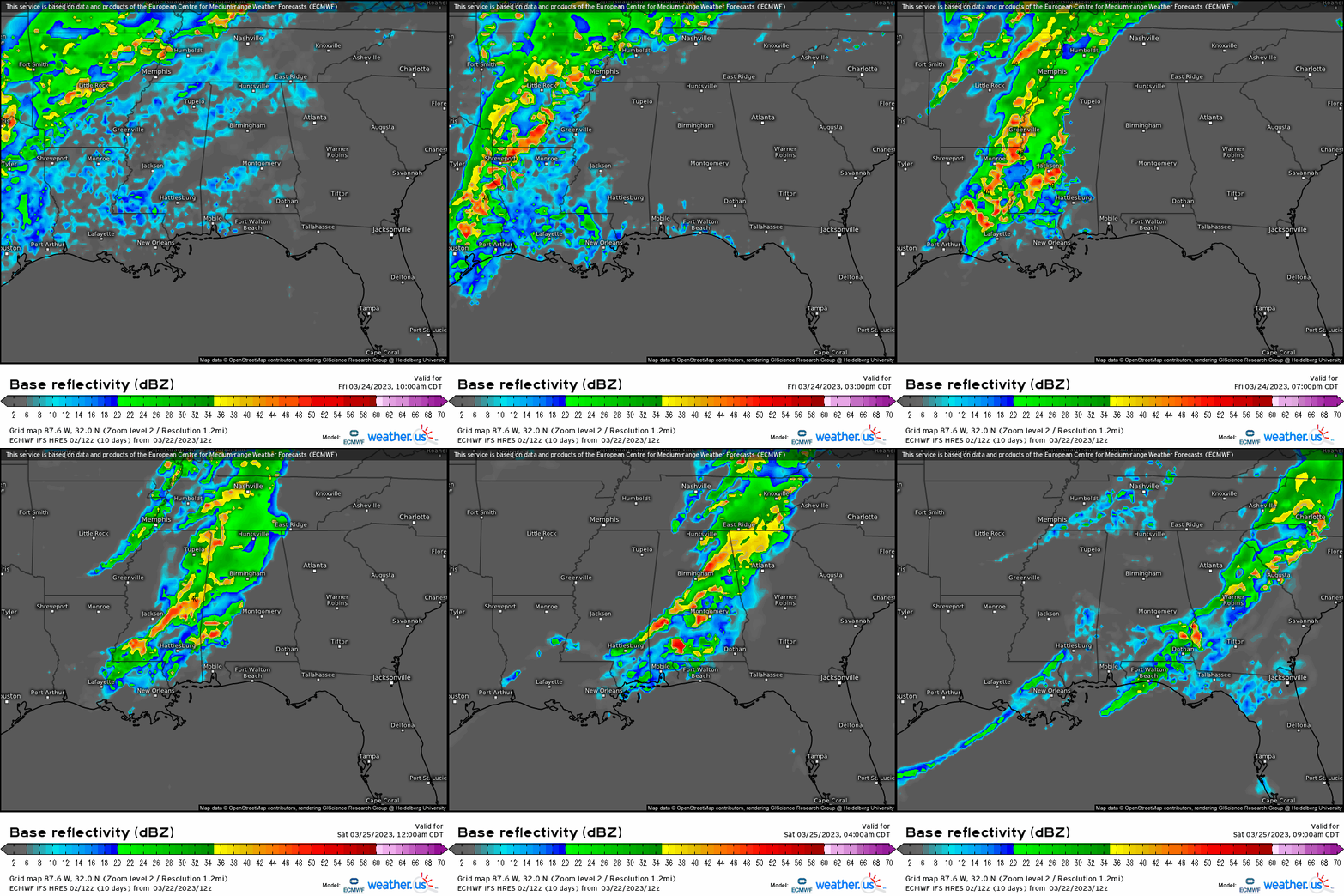
As far as timing goes, expect the event to kick off over eastern Texas in the early afternoon hours. The threat will steadily move eastward with time and is expected to be at its most potent in the late afternoon/early evening hours. The severe threat is expected to persist into the overnight hours for places like Alabama and some of Middle Tennessee, so don’t let your guard down once the sun has set.
Hi-res models are just coming into range for Friday’s event, so I would expect a few adjustments to the forecast and “most at risk” area over the next day as we really get a handle on the conditions.
Take Action:
- There is a risk for severe weather both Thursday and Friday this week. If you are in the defined risk area, check your forecast often to have the most updated information.
- Thursday’s main hazard seems to be large hail, but a tornado or two and damaging winds are also possible.
- Friday’s threat will be much more dynamic with (strong?) tornadoes possible as well as damaging winds.
- Friday’s forecast is still coming into focus. If you’re under the defined risk area, closely monitor any changes to your forecast or the timing.
- Anyone at risk for severe weather either Thursday or Friday should have multiple ways to receive warnings, including at least one that will wake you. Have your safe space ready to go should you need it.
- Warn your friends, warn your family. Increase awareness for this event in the hopes that no one is caught unawares.


