
Thinking Spring
It’s just about that time of year again where elected officials yank a grouchy rodent out of his warm burrow and determine the long-range forecast based on weather or not said rodent has seen his shadow.
While this is great for entertainment purposes (though perhaps not for the groundhog himself), we all know, or should know, there’s no actual science to it.
Luckily, we have forecasting tools based in science that can help us determine the chances of an “early” spring. While I personally am not a fan of forecasting beyond 7 days, there is skill in pattern recognition and teleconnection analysis to determine likely scenarios. So, will we see an “early spring?” Let’s take a look.
We’ll start with our teleconnections.
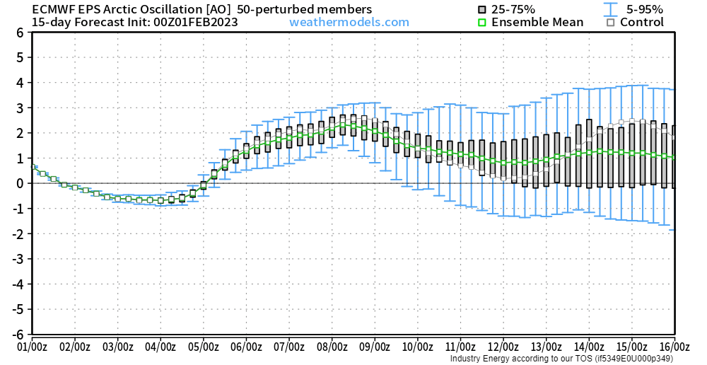
The Arctic Oscillation (AO) is currently weakly negative, meaning that some Arctic air is filtering southward. This is apparent from the current frigid temperatures in the Central US and the forecasted quick hit of Arctic air for the Northeast later this week.
After that, however, the AO looks to become positive for the medium-term. This means that any Arctic air will remain firmly locked up in its rightful place. Any Arctic intrusions into the lower 48 seem unlikely from next week through mid-month.
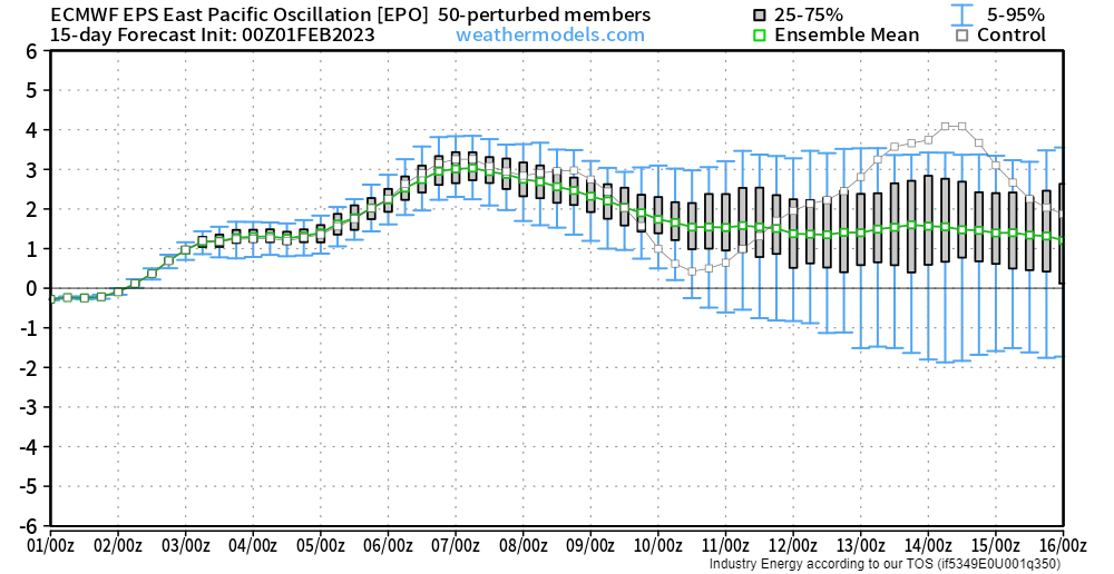
The East Pacific Oscillation (EPO) is currently neutral, but trending toward the positive phase.
In it’s positive phase, low pressure is found in the Gulf of Alaska. The flow around the low pumps temperate maritime air into the lower 48.
In contrast, a negative EPO would indicate ridging over the Gulf of Alaska which, if amplified enough, would promote cross-polar flow and Arctic intrusion into the lower 48.
So, with the EPO in it’s positive phase, Arctic air filtering south is much less likely.
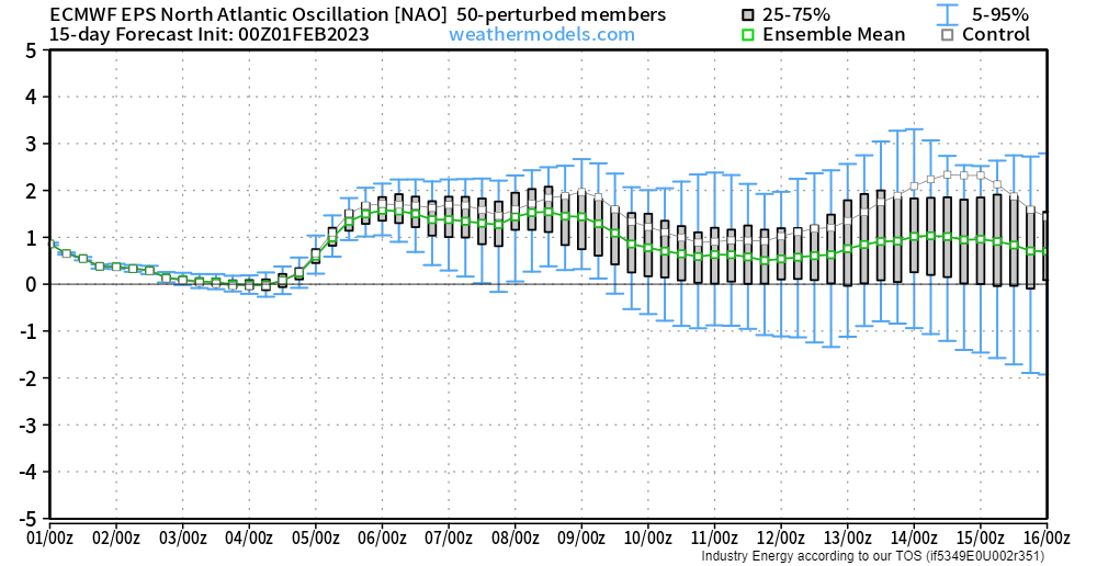
The North Atlantic Oscillation is currently weakly positive and forecast to trend neutral and then return to a stronger positive phase in the medium term.
This indicates a lack of high-latitude blocking. In other words, blocking high pressure near Greenland/Iceland is nowhere to be found. The flow across the US can move along without a hitch. While this doesn’t guarantee that there will be no cold air intrusions (we’ll need to look to the EPO and AO to determine that), it does suggest that if any cold air does materialize, it will likely be short-lived.
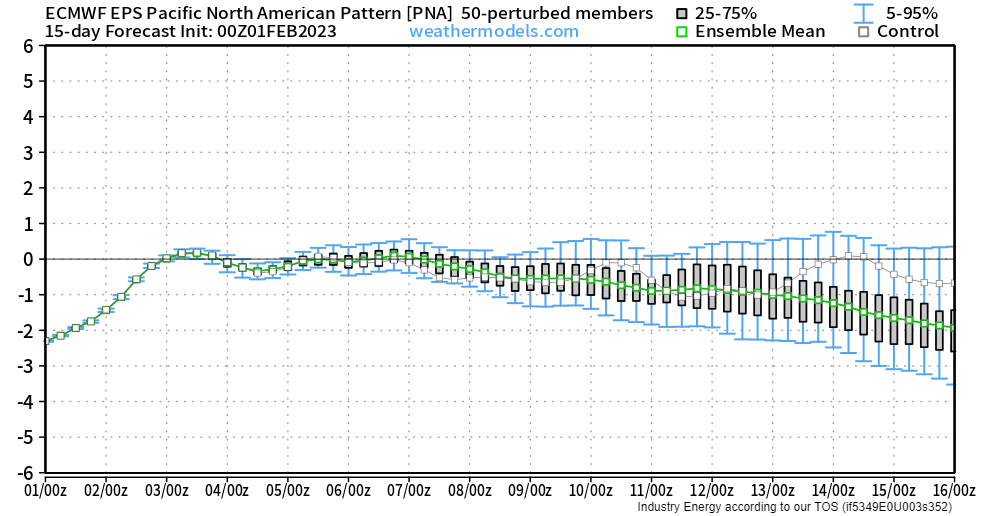
The Pacific-North American Pattern (PNA) is currently in it’s negative phase. This would indicate troughing in the West and ridging in the East. As we currently have an active pattern out west and the southeast ridge holding strong in the East, we know this to be true.
In the medium-term, the PNA is forecast to remain neutral or trend back toward the negative phase. This would point toward continued ridging in the East and more neutral-to-variable heights in the West (a flip-flop from troughing to ridging and back again).
So, let’s put all of these together and see what we’re looking at:
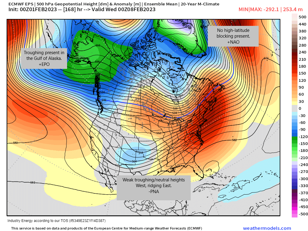
By looking at the 500 mb height anomaly, we can clearly visualize what I outlined above.
- Troughing is present in the Gulf of Alaska indicating a +EPO.
- Weak troughing/neutral heights are present in the West with ridging apparent in the East indicating a neutral to negative PNA
- Deep troughing is apparent over Greenland. No high-latitude blocking is in sight, indicating a +NAO
- Polar heights are fairly neutral and not stretched southward, indicating a neutral to positive AO.
What does that mean for temperatures at the surface?
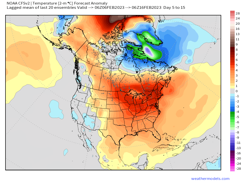
After this weekend and through roughly mid-month, it suggests more “spring-like” weather east of the Rockies while those west of the Rockies experience near-average conditions.
So it seems that, at least in the medium term, some of us will experience an early spring. Can it change? Of course. The forecast is always evolving as factors come into focus.
Will it last? It’s a bit too early to make that call. Historically, however, February is a bit too early to be completely done with colder air anywhere.


