Using Teleconnections to Look For Wintry Weather in the East
Tornadoes in November are weird. I mean, we know they occur – and quite often at that. But it just doesn’t feel very festive when you’re decorating that Christmas tree while simultaneously keeping one eye on the wall-to-wall tornado warning coverage from your local station.
So then, when will it FEEL like Christmas over here in the Eastern US? While we can’t really say with any certainty, we can use teleconnections to identify a pattern that may bring some of us cold temps and wintry weather.
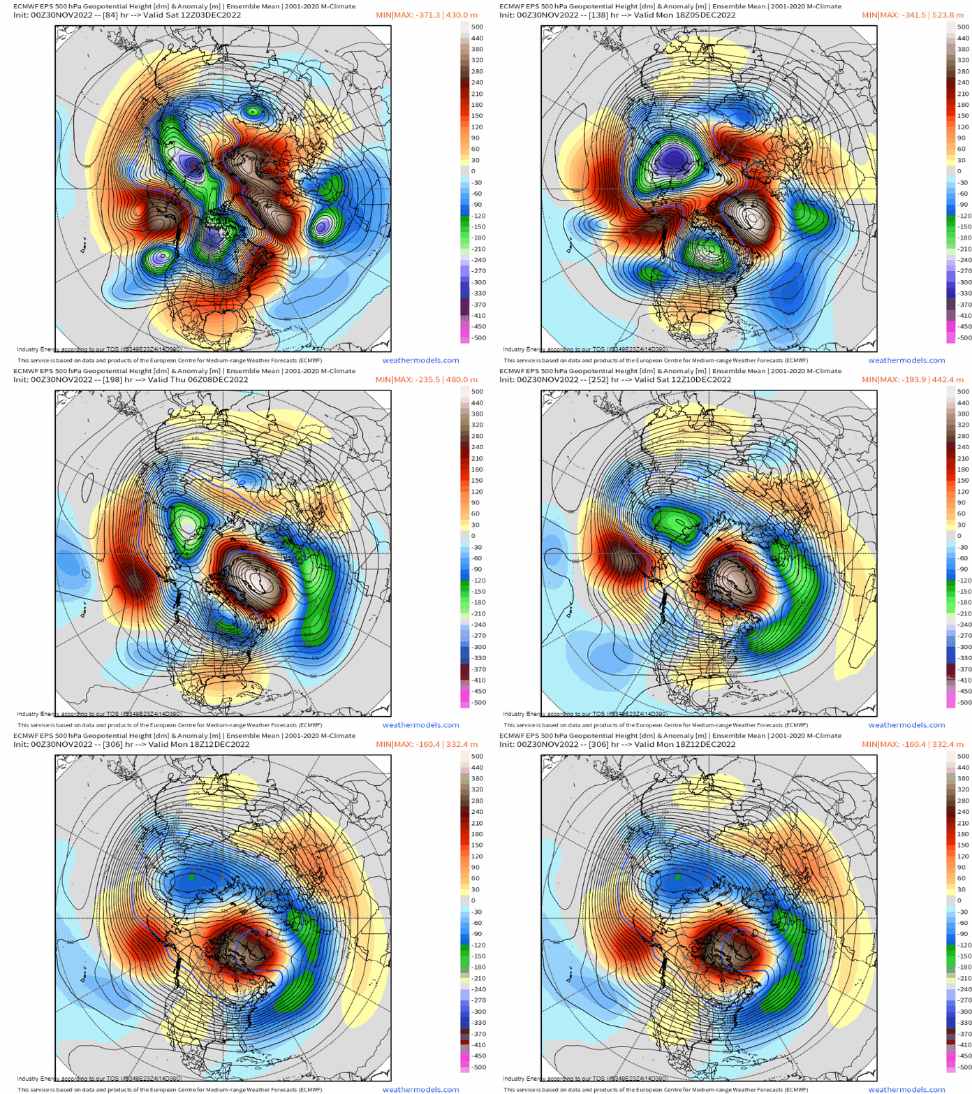
Our atmosphere is a fluid. Every motion has a downstream impact. Just look at the graphic above: where one ridge rises, a trough must dig, etc.
Changes in phases of certain teleconnections (weather patterns in other parts of the world) can produce conditions favorable for a cold and snowy pattern in the Eastern US. To identify this possibility, we need to look at the Artic Oscillation (AO), Eastern Pacific Oscillation (EPO), North Atlantic Oscillation (NAO), and Pacific-North American Pattern (PNA).
The ideal configuration for a period of winter weather in the eastern US is a -NAO, -AO, -EPO, and +PNA. Can other combinations still produce winter weather? Sure, but this combination is almost a guarantee.
Arctic Oscillation
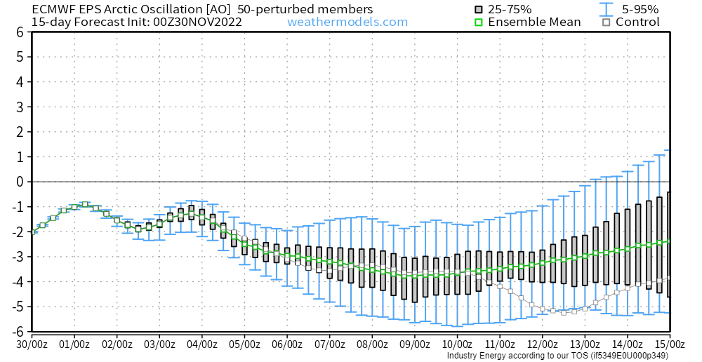
The AO determines whether or not there will be a supply of Arctic air available to fuel winter weather. A +AO indicates that Arctic air will stay locked up near the poles while a -AO indicates the potential for Arctic air to escape southward.
While the AO is vaguely negative right now, it looks to become more significantly negative around the 2nd weekend of December.
Eastern Pacific Oscillation
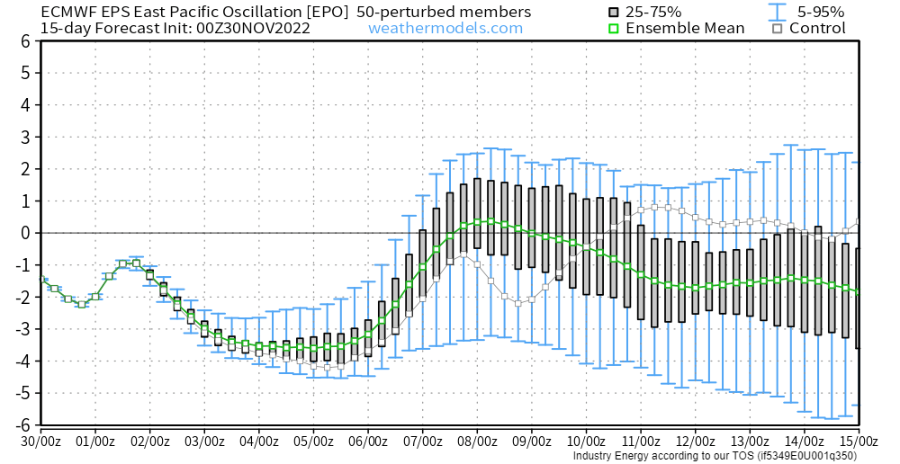
The state of the EPO controls whether or not there is a chance for cross-polar flow. Or, in other words, a path for Arctic air to flow across the pole from Siberia and spill into lower latitudes. During a -EPO, a ridge builds over Alaska. The more amplified this ridge is, the greater chance for cross-polar flow. Conversely, a +EPO indicates a large, persistent low in the Gulf of Alaska and results in warmer weather for the lower 48.
The EPO looks like a bit of a roller coaster ride in the short term – swinging from decently negative to vaguely positive. But toward the 2nd weekend in December (when the AO may go rather negative), it dips back to somewhat negative.
So, so far for the period around the 2nd weekend of December, we have a -AO and a somewhat -EPO.
North Atlantic Oscillation
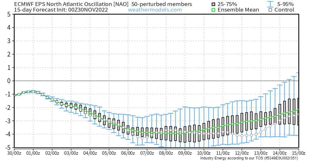
The NAO, in its negative state, indicates high-latitude blocking over Greenland. This lingering area of high pressure causes the flow to stagnate. The storm track is often underneath it and can result in persistent storminess for the Eastern US. Conversely, a +NAO has no such block and the storm track moves quickly across the Atlantic.
Can the Eastern US still get winter weather with a +NAO? Yes, but they’re often quick-hitters and rarely significant events.
The NAO, which is vaguely negative now, is forecast to become substantially negative as we progress through early December and strong high pressure retrogrades westward near Greenland.
If you’re keeping track, that’s now a -AO, -EPO, and -NAO for the time frame near the 2nd weekend of December.
Pacific-North American Pattern
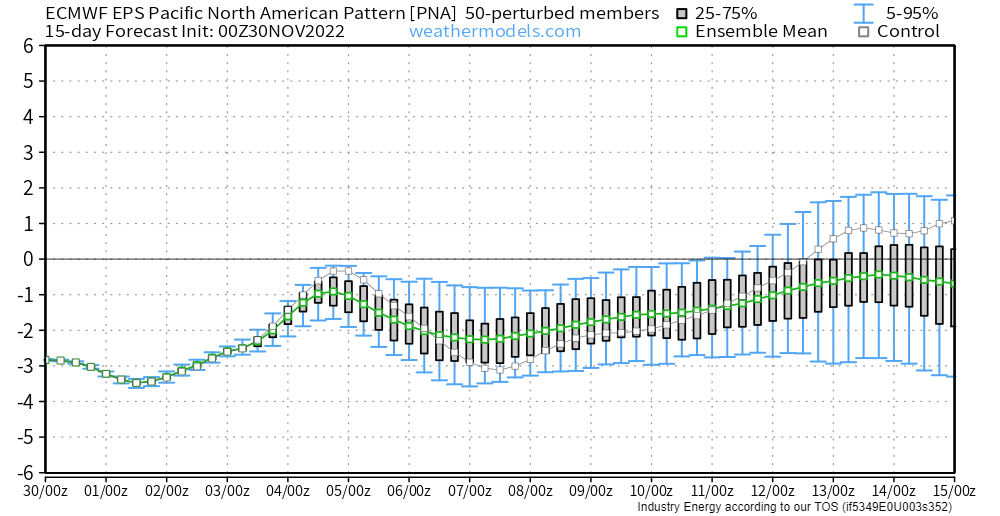
The state of the PNA generally indicates where troughing and ridging is located over the lower 48. In it’s negative state, troughing is likely over the Western US with ridging in the East. Conversely, a +PNA indicates ridging in the West and troughing in the East.
The caveat here is that sometimes a weakly negative PNA can result in some degree of troughing in the East as well.
So, using these ensemble forecasts (which are NOT gospel, especially since it’s roughly 10 days out and can change a lot in that time), we now have a -AO, -EPO, -NAO, and a PNA that could be somewhere near neutral during the time frame around the 2nd weekend of December.
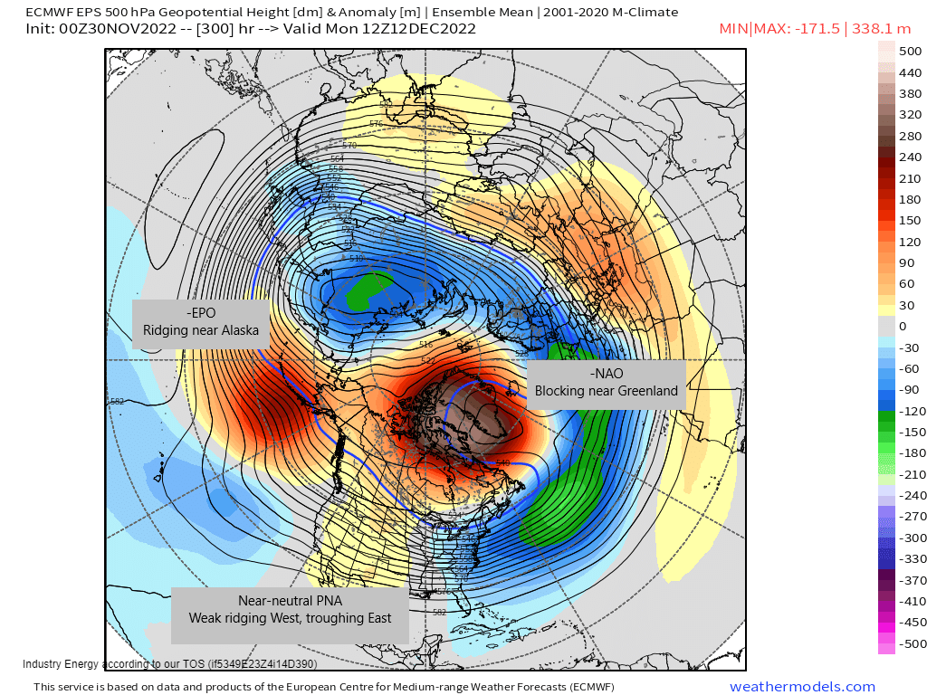
Looking at a 500 mb height anomaly map, we can see 3 of the 4 teleconnections as we discussed them above. If you’ll check out a 850 temperature map, you’ll see Arctic air flowing southeastward into the Eastern US around this timeframe as well.
Just a note: I used the EPS for this explanation just to be consistent. However, it’s worth mentioning that the GEFS currently displays a very similar forecast.
Again, we are at least 10 days out from these patterns combining, so it is by no means a certainty that it will occur as forecast here. But, part of forecasting is looking ahead to see what could be while constantly adjusting to new data as it arrives. For now, with general agreement between the GEFS and EPS, those of us wishing for a little holiday cheer can hope it does play out as forecast.
Hope you learned something new today!


