A Meteorological Col Incoming – Ridging on Both Sides of Country with Below Average Heights in The Middle
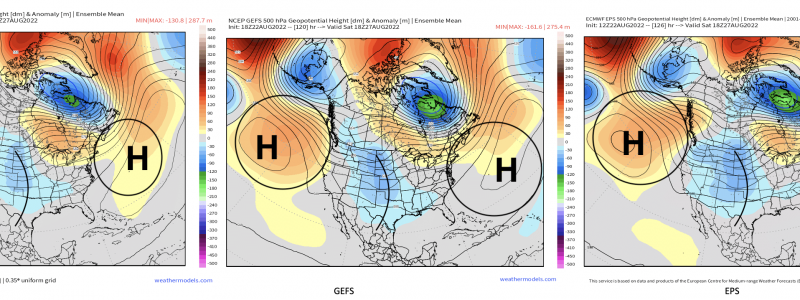
A “col” in meteorology is simply the point of an intersection between two areas of high pressure, or two areas of low pressure. We’ll be seeing an example of one across the CONUS that manifests into the end of the month and into the month of September.
In this case, toward the end of August, the z500mb geopotential height pattern will do a “reshuffling”. There is a great deal of agreement amongst various ensembles as well!
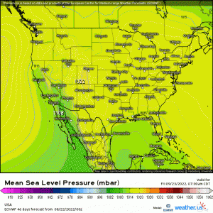
Below displays the EPS Mean Sea Level Pressure (MSLP) through the end of the month and into September. Notice how relatively above average pressures prevail west and along the Rockies, and then along and east of the Appalachian Mountains. Meanwhile, slightly below average/average pressure dominates the midsection of the country down into and across the Southwest and Deep South. The latter we can expect an active pattern for precipitation (which is welcomed especially given the large drought across these regions) and mitigating blistering heat. The former is where we can expect above average temperatures and average precipitation (barring any nearby and close call tropical cyclone rainfall!), except the Pacific NW and West coast will likely deal with more sinking air given the persistence of ridging.
Regional Breakdown:
Out across the Pacific Northwest, Intermountain West, and generally West of of the Great Plains – Upper level ridging will return. Once again, an anomalous ridge will build and center itself across the Northwest region and into British Colombia early next week, once the troughiness extends eastward. This’ll bring above average temperatures to these aforementioned areas and below average precipitation heading into early September.
Along and east of the Rockies, Great Plains, and into the Midwest – expect seasonable temperatures downstream of the upper-level ridge axis with near average precipitation expected. Further to the Southwest and Deep South, this is where we expect the focal point (i.e. “col” reference) for below average heights and possibly above average temperatures as a result.
Downstream the general mean troughiness, above average heights are expected to billow along and East of the Appalachian Mountains down into the Southeast. With that expected, above average temperatures and humidity will follow. Seasonable to slightly above average precipitation can be expected given the moist southerly/southwesterly flow in between the trough across the Midwest and Deep South, and the Bermuda ridge out across the western Atlantic.
This weekend, as shown by ensembles of the GFS, ECMWF, and the CMC; a long wave trough propagates from the upper Great Plains/Northern Rockies down toward the midwest. Behind it, upper-level ridging builds into the Pacific NW. Downstream of the trough, heights begin to rise east of the Mississippi River. Herein is your visualization of the col with the area of lower-than-average heights centered in between two areas of mid/upper-level ridges.
Link for all three ensemble forecast systems
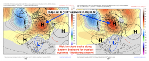
Next week and into September, an anomalous ridge builds into Southern Canada and across the Intermountain West. We see the mean trough allocate and begin to meander across the Deep South and Midwest while ridging continues to build out across the Eastern Seaboard.
By September, we see the same quasi-stationary pattern as advertised earlier in the forecast period with ridging on both coasts and including Central Canada, with troughing over the midsection of the U.S. I did want to include that there is certainly risk for a track that theoretically track very close to the Eastern Seaboard given this mid-level height pattern. It’s during this period as well (8-15 Day) we may be a bit busy with the state of the tropics out across the Atlantic (TBD!).
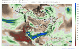
Lastly, here’s the CFSv2 (a climate model used for medium to long range forecasting) corroborating with the discussed height pattern, the expected precipitation output for the various regions. You can denote the dipole of dry West/Northwest and wet South/East, consistent with the synoptic pattern.
Those who are sick of the heat and summer in general, just know that Meteorological Fall is literally on our “doorstep”, as September 1st is already next week!


