Southern Severe, Northern Ice
There’s no rest for the weary this week as another potentially impactful system takes shape. This will be the 4th big weather-maker since New Years! 2022 really has no chill so far.
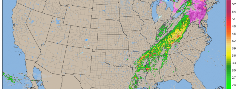
This upcoming system has two parts to it – a southern severe component and a northern winter weather component. Let’s take a look at the set-up.
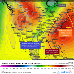
I’ve annotated the graphic above in an effort to give you a visual of the conditions involved in the set up since it is somewhat complicated.
A broad area of low pressure descending the Rockies will split into two as it moves east. The primary, more powerful low will form and deepen in Canada while a secondary, much weaker low sweeps into the Southern Plains.
The southern low will facilitate moisture return and provide enough lift later today for a few storms to form ahead of a front.
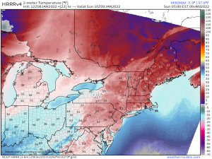
The northern low will advect relatively warmer air northward ahead of its front, making this largely a rain event. The exception will be areas east of the Appalachians where cold air damming will keep surface temperatures cold enough for mixed precip.
Let’s look at these halves separately.
Severe Threat
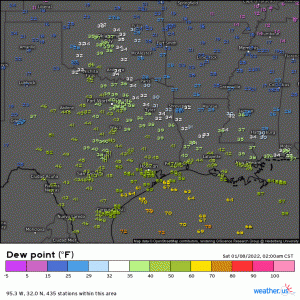
Already this morning we can see moisture return underway in the Western Gulf as dew points in the 60s creep northward.
With a strong low level jet already in place and forecast to continue/increase throughout the day, a steady stream of moisture will be brought into this area. Though deep layer shear isn’t the best, the strength of the low level jet will make up for what the upper atmosphere is lacking.
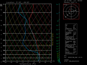
This is a forecasted sounding from just north of Houston for this afternoon. It shows a wide, curving hodograph indicative of strong low-level shear along wind winds backing from the southeast for a bit of added directional shear.
Lapse rates aren’t that great, however, and this may be a limiting factor in regards to how widespread the severe threat becomes. Without that sharp decrease of temp with height, supercells don’t have the ability to really strengthen. Still, these conditions could be enough for a few rotating storms that produce a tornado or two this afternoon.
Later tonight, cooler air from the northwest is expected to overspread the region aloft. This would increase the lapse rates and introduce the risk of severe hail to parts of Arkansas in the overnight hours.
The threat then shifts to the Deep South on Sunday.
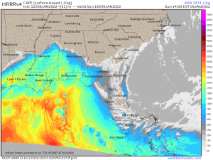
Continued convection ahead of the cold front is expected early Sunday into the evening hours.
The warm front isn’t forecast to lift very far north, therefore the better environment for a few strong to severe storms will exist closer to the central Gulf Coast. It is here we will find the risk for an isolated tornado or two.
Overall, this isn’t expected to become a very potent threat. However, there is still some risk. Be weather aware from the Southern Plains through the Deep South today and tomorrow.
Winter Weather
As I mentioned initially, the primary low located in Canada will be pulling some warm-ish air northward ahead of the front, making this mostly a rain event.
The exception will be parts of the Mid-Atlantic/Northeast – mainly Pennsylvania, New York, and some of New Jersey – that are east of the Appalachians.
The clockwise flow around an area of high pressure just offshore will direct colder air from eastern Canada back toward the northeast. This colder air flows inland and meets the Appalachians. Since cold air is dense, it is unable to rise over the mountains and instead lingers in place. This is called Cold Air Damming.
Warmer air being pulled north by the low will overspread the colder air, creating conditions ripe for freezing rain.
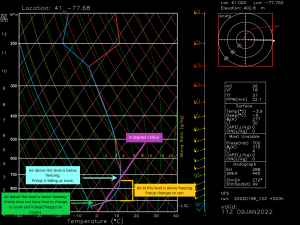
The above is a forecasted sounding pulled from Northeast PA around dawn. You really don’t get more of a classic freezing rain sounding than this.
The air aloft is below freezing, except for a shallow layer not far above ground level. The air at ground level is well below freezing. The precip will begin as snow aloft, then change to rain in the warm layer. Once it re-enters the very shallow cold layer at the surface, it won’t have time to refreeze into snow and instead will freeze on the surface it comes into contact with.
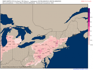
As the air at the surface isn’t expected to warm very much ahead of the cold front, this could lead to a prolonged period of freezing rain resulting in hazardous ice accumulation.
Poor road conditions and even a few power outages due to falling tree limbs are possible.
If you wake up tomorrow in the northeast and your surface temperature is below freezing, do yourself a favor and stay home. Roads will likely become very slippery very quickly and you risk accidents or even becoming stranded.
If you have no choice but to travel, make sure you have enough supplies in your car to last if you do become stranded. Food, water, ways to stay warm, a full gas tank – all these things are necessary. Prepare today if need be.
Stay safe!
