New Year’s Severe Update
Though we don’t quite have all the answers just yet, I promised an update on the New Years Eve/Day severe threat. Let me start this off by saying this has the potential to be a significant threat. I say potential because it’s a bit conditional. Let’s look at what we expect and what the unknowns are.
Tonight
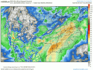
A low level jet ahead of the forming surface cyclone will begin to strengthen as early as this evening.
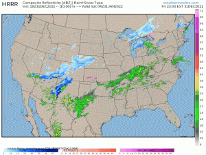
As that cranks up, so does the advection of both moisture and warmth, expanding the warm sector. Storms are most likely along the lifting warm front, where extra forcing is.
The ones that form here will be capable of damaging winds and perhaps some hail. Should any of the storms along or near the warm front be capable of developing into a supercell, the risk for a tornado or two will exist as well.
Development in the open warm sector (MS/AL) is a bit in question. Instability is currently limited and with no extra forcing, storms may not be able to get going. However, if any manage it, they will likely be supercells and carry the threat for damaging winds and a few tornadoes.
The areas most as risk are far eastern TX, AR, northern LA, TN, KY as the warm front lifts, however points further south need to monitor development as well.
I realize tonight is New Years Eve and people like to party. This is not the night to go get blind drunk if you’re in the states I just mentioned. Keep your weather radio on or make sure you have a way to get warnings if you’re out celebrating. Have a plan to shelter either at home or know where to shelter if you’re out.
Much of this activity won’t kick off until closer to midnight and dangerous weather could be occurring while you’re out and about. Be weather aware through the evening into the overnight hours.
Tomorrow
Tomorrow morning, the cold front will be working it’s way east and the threat is (conditionally) much greater.
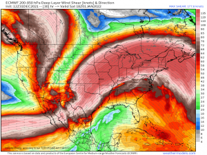
Instability is forecast to remain somewhat weak as ongoing showers and storms keep the clouds around, inhibiting daytime heating. However, the forcing with the front combined with the forecast deep layer shear is more than enough to overcome the issue of mediocre instability.
Deep layer shear on the order of 50 to 60+ kts is forecast. An environment like this is simply ripe for strong tornadoes.
Except for one thing standing in the way. This is the conditional part.
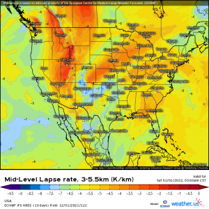
Warm air in the lower levels is forecast to keep lapse rates down.
In other words, the atmosphere may remain capped. We need steady, significant cooling with height in order for a storm to really take advantage of the environment and strengthen through updrafts. The instability would need to be somewhat greater to break the cap without the assistance of frontal forcing. If the cap aloft materializes as forecast, it could prevent multiple strong supercells from forming and instead lend to a few isolated stronger storms.
If the warm air aloft does not materialize or erodes quickly, there won’t really be anything stopping this from becoming a potentially significant event with strong tornadoes possible.
Really, quite a bit depends on the existence and strength of the cap tomorrow. Regardless, there will be a line of convection preceding the front and damaging winds are possible along with a few QLCS tornadoes.
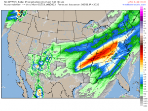
There is also a risk for flash flooding.
This system will have access to anomalous moisture. The area it is tracking over just received a soaking from a system that rolled through earlier in the week. The ground is saturated and has not had a chance to dry out between rounds of on-going rain.
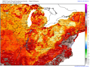
FFG values are pretty low from Central Alabama, into Tennessee, Kentucky, Ohio, and West Virginia.
The heaviest rain will be focused along the frontal boundaries – first the warm front and it lifts and stalls and then with the cold front as the convective line swings through. Heavy totals are possible and unfortunately, the corridor of heaviest rainfall runs over areas with low FFG values.
Safety
Remain aware of the weather this evening, overnight, and throughout the day tomorrow. Monitor the evolution of the forecast as one relatively small change can make the difference between widespread severe storms and isolated severe storms.
If you’re out tonight, have a plan to shelter in case you need it plus have ways to receive warnings. If you’re driving, be mindful of the flash flooding risk and don’t drive across a flooded roadway.
Be safe, y’all. And Happy 2022!
