99L’s Future Uncertain, Still a Potentially Significant Threat
If you’re at all in tune with the weather community, you’ve likely been hearing quite a lot of chatter about Invest 99L in the Caribbean. In fact, you may have read Jacob’s blog on the subject yesterday. Today’s blog will be building off that subject because, frankly, 99L is poised to pose a very real threat to the Gulf Coast. More importantly, with impacts expected by the end of the weekend and great uncertainty in the forecast, those potentially in the path need to be paying attention and preparing.
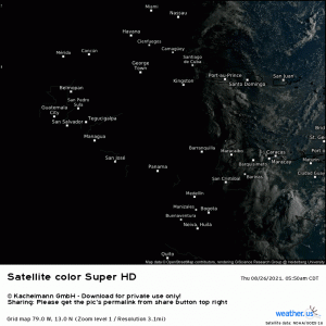
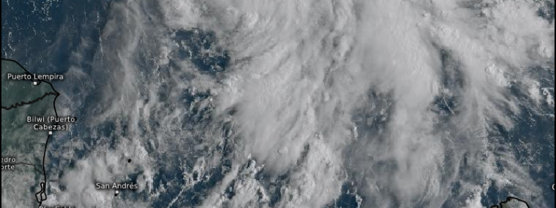
The first visible satellite images this morning show an organizing system steadily bubbling away in the NW Caribbean with perhaps a hint of a center. Though it is being sheared some from the WNW, development into a TD or TS is expected later today.
Where the center decides to set up is actually pretty important.
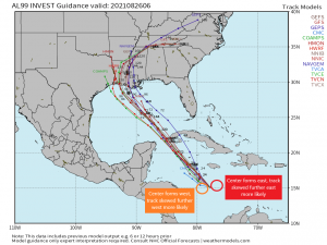
Should it form west of what is currently expected, the track forecasts will nudge to the west, keeping a Texas landfall in play. Should the center form east of what is expected, track forecasts will nudge east, perhaps putting an eastern LA/western MS landfall in play.
After examining the visible satellite images available so far, the western solution seems less likely as the storm seems to be consolidating closer to Jamaica. This is likely why this morning’s spaghetti models have all but taken a mid/southern Texas landfall out of the picture. Still, as a center is not apparent quite yet, uncertainty remains.
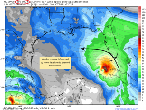
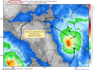
While the center is important for ultimate track, it’s not the only factor. Strength will also determine where the TC goes. A stronger storm will be steered by upper level winds while a weaker storm is influenced by lower level winds.
Ultimately, this storm will be influenced by the clockwise flow around a strong high to the east. However, wind direction is never exactly the same in all levels of the atmosphere. Different levels experience different influences, especially closer to the surface where we must contend with factors like friction or turbulent drag that change the direction of the wind.
So, in the case of a weaker TC:
The lower levels will steer it, making its direction a bit more WNW.
In the case of a stronger TC:
Upper levels will influence it, making its direction more NNW.
You can see how factors yet to be determined (center location, strength) have a huge impact on ultimate track and account for the degree of uncertainty we’re seeing right now.
As far as intensity goes, any land interaction will determine the early intensity. Should 99L cross Cuba as some models suggest, the interaction could disrupt it’s circulation (remember when Fred all but died almost 2 weeks ago?). However, assuming the circulation remains intact to some degree, an extremely conducive environment awaits 99L in the Gulf.
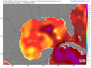
Extremely warm waters, with a significant pocket of heat potential near where 99L is forecast to track, and negligible wind shear will offer the TC the perfect environment in which to intensify.
The board is set for a potentially significant storm. We just need to see where the pieces fall before making any further calls on landfall/intensity.
When I began this blog this morning, my main intent was to communicated not only the potential, but also the uncertainty. It’s easy to get worked up over single, deterministic runs of one model. Ignore them. Until that center forms, they carry no weight. Is a strong hurricane possible? Yes. It’s August, the Gulf is warm, and shear is low. But for now, we wait and watch the trends.
On the other hand, the amount of uncertainty is a bit of an issue. As far as a timeline goes, there really isn’t much time between expected formation (when the forecast becomes more solid) and expected impacts. As it stands now, impacts could begin as early as Sunday night. For this reason, I strongly encourage those from Texas to Alabama to begin making plans and be ready to execute them should you find yourself in the cone come tomorrow evening. You will not have much time to complete your preparations.
In summary: uncertainties abound, for now, with 99L. The Gulf coast from Texas to Alabama needs to have their plan ready in case they need to execute it once the forecast becomes more certain as effects may be felt as early as Sunday evening. Monitor the trends closely and ignore the hype of single, scary model runs.
