Henri Threatens New England With First Hurricane Landfall in a Generation
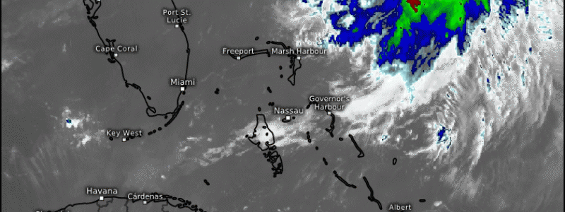
Tropical storm Henri churns over open water between Bermuda and Florida today, slowly moving a bit north of west. There is increasing confidence that the storm could be New England’s first hurricane in 30 years.
This blog will outline the meteorology of the storm, and then will outline the probable impacts. I recommend reading the entire thing to get a grasp on the physical contingencies impacting Henri, but feel free to skip to the The Impacts header if you’re suffering information overload. I get it.
The Atmosphere
As I wrote about yesterday, a likely litmus test for impacts in the northeast was how well Henri stood against strong shear imparted by a stout Bermuda-area trough. A more resilient storm would more likely hook northeast into a stout midlevel trough over the eastern seaboard, while a storm weakened would more likely follow a ridge out to sea.
Well, Henri is a fighter, and never decoupled in the face of disorganizing northerly flow. Now, as the near-hurricane-intensity storm migrates under a ridge axis to lower shear and warmer waters, it seems the weaker/out to sea option is sliding increasingly off the table as the storm has bypassed the most likely exit on the highway to New England.
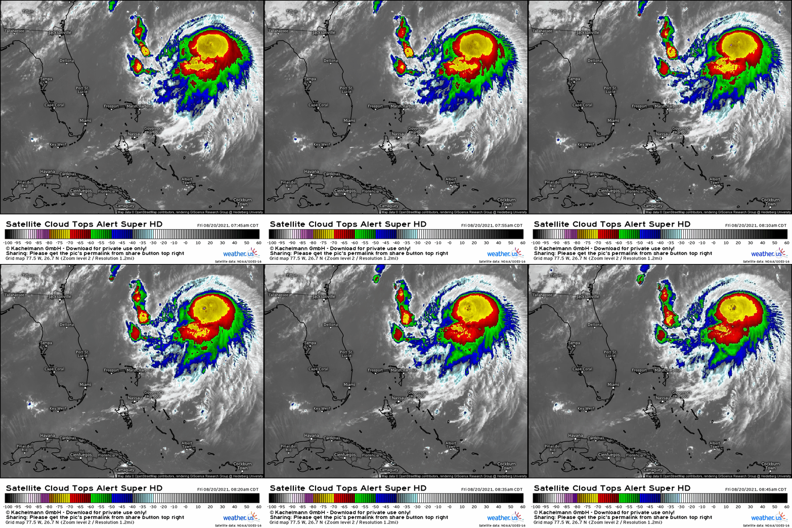
Satellite shows a storm with healthy, bubbling convection well organized around a symmetric center. Outflow fans to the south, and the cirrus field north is becoming less ‘compressed’ by northerly shear with time.
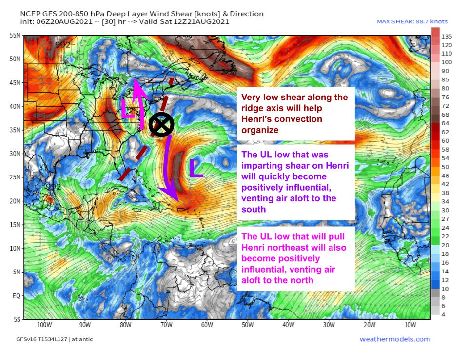
As the Bermuda trough slides southwest and a ridge develops northeast, Henri will steadily find shear decrease to very low values over the next 24 hours. In fact, upper level winds will not simply be *not unfavorable*, but rather actively favorable as northerly flow east and southerly flow west serve to ‘vent’ flow in the upper levels, helping deepen Henri more rapidly.
Sea surface temperatures will also be very favorable for TC intensification, as the sun-warmed Gulf Stream vicinity ocean water should reach a roasting 29-29.5ºC as far north as Delaware. The confluence of factors means Henri will almost certainly reach hurricane intensity by tonight, with a stretch of rapid intensification into a stronger hurricane not at all out of the question by tomorrow afternoon. I think there’s at least a 5-10% chance we see a major (cat 3) hurricane by this time tomorrow.
Also tomorrow, interactions with the east coast trough will begin accelerating Henri north at quite a fast rate. The storm’s official forecast calls for a jump of around 4º latitude in 12 hours, which means Henri’s shot at rapid intensification amidst favorable shear and bathtub SSTs will come to an end fast. Whatever intensity we see tomorrow afternoon will likely be the storm’s peak.
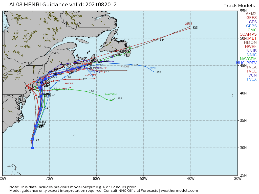
Come Sunday, the storm will likely begin hooking northeast, which will both slow it and expose it to cooler, shallower shelf waters off the New England coast. This combination will begin to weaken the storm, though baroclinic processes and a likely high baseline intensity means category 1 hurricane intensity is still probable by Sunday afternoon, when Henri will approach the coast of Long Island, Connecticut, Rhode Island, or Massachusetts. If Henri ends up weaker than a mid-range category 1 tomorrow, it will probably landfall weaker, probably as a tropical storm. Uncertainties as to exactly where this landfall will be are not overly large, but considering the populous region of interest, any shift in guidance could matter a lot.
As usual, intensity will have a big say in where the storm tracks, with a more intense Henri likely to landfall further west due to stronger reliance on southeasterly steering from the east coast trough.
The Impacts
Tropical storm Henri could be a very, very destructive storm. It could also be a fairly moderate event. The distinction depends on the exact landfall location and intensity, which we still don’t know due to the complex nature of the atmosphere and the trough/cyclone interaction that will bring Henri inland. Because of this, I’ll be speaking in approximate probabilities based on my best forecast judgement.
Wind risk
Wind is the first hazard many think of when it comes to hurricanes, and New England is unusually vulnerable to it. Much of the northeast is a mess of tree limbs, population density, and above-ground power lines that makes the region extremely susceptible to massive power outage events. This worry is deepened by the possibility of Henri being a stronger storm on landfall than the region has experienced in 30 years, meaning mature trees have never been stressed by the caliber of wind possible.
Assuming Henri makes landfall in Rhode Island or far east CT, which is currently around the center of both the NHC forecast and model guidance, the highest winds will be felt in Rhode Island, eastern CT, and eastern Massachusetts, potentially including the Boston and Providence metros. Given excessive soil saturation from Fred, which weakens the grip soil has on trees, widespread power outages are possible regardless of the intensity at landfall. If Henri impacts land as a mid-range category 1 hurricane, a reasonable worst case scenario, power outages could be the worst in modern history for the region. This will be a long fused event, and could feature high wind speeds. If Henri ends up weaker, or east over Cape Cod, wind impacts will be more moderate, though still significant.
Wind damage to homes will almost certainly be minor even in the reasonable worst case scenario of a strong category 1, though residents should take care to secure objects prone to flying around, like umbrellas and trampolines.
Further west, into central Connecticut and Long Island, wind impacts will still probably cause significant power outages, tapering off into western portions of the region. But if Henri continues trending west with landfall location, which is a reasonable worst case scenario for the region, Connecticut could see its worst power outage event ever. This will be a long fused event, and could feature high wind speeds.
Residents in all the areas mentioned above should prepare for power outages, stockpiling a few days worth of water bottles, perishable food, medication, and batteries.
All of these measures should be taken by tomorrow night before tropical storm force winds commence.
Storm surge
Storm surge could be a significant risk with Henri as the storm slows down on approach to landfall, allowing long-fetch surge accumulation over several tide cycles. This risk will be increased by the vulnerability of south-facing bays along Rhode Island, far eastern CT, and Massachusetts, and could extend into Long Island or central CT if the track trends west. If you live along vulnerable coastline in Cape Cod, southeast MA, south RI, east CT, south LI, or central CT, in that order of likelihood, prepare for the possibility of necessary evacuations.
Extended northerly flow could also send a degree of surge to places that don’t usually see it, like the north short of LI, perhaps including locations near NYC that face north.
Additional measures to protect property could be necessary, like removing boats or putting up sandbags, depending on the nuances of your situation and location. Be sure to stay tuned to advice from local officials.
All of these measures should be taken by tomorrow night before tropical storm force winds commence.
Fresh water flooding
After Fred drenched much of the northeast with excessive rainfall this week, soil moisture is about as high as it gets this time of year from Buffalo to New Haven to Concord. With an unusually slow-moving storm expected, a large swath of prolific rain could lead to substantial river, flash, and urban flooding in portions of New England.
The heaviest rain will likely be just west of the track, as no major predecessor rain event is forecast due to trough orientation. This will probably bullseye parts of RI, LI, CT, and central MA for 4-10″+ of rain, though this corridor could shift if the track does.
This could be one of the more memorable aspects of Henri. Danger is especially high from Hartford to Boston, a populous corridor that just saw 2-6″ of rain from Fred. With limited ability to take in new rainfall, critical runoff is probable, especially if the highest rainfall totals fall along this swath.
There’s also a low probability of a track that enhances orographic lift along the Catskills, which was shown by today’s HWRF. This could bring prolific rainfall (15+”) to slopes at risk of mudslides and flash flooding. Residents of this part of NY should stay tuned- while unlikely, this would be substantially impactful.
That’s all for now, folks. Stay tuned to the NHC, your local NWS office, and read this for more information on how to prepare.
Stay safe out there.


