Widespread Severe Weather Possible to Start the Work Week
The first thing I noticed when I stepped out the door this morning to take my son to school was just how humid it was.
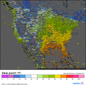
Look at those dew points. Readings in the 60s extend all the way into Iowa and Virginia and its barely past 8 am. Knowing that severe weather is on tap today and that it was already so humid made me stop and say “uh-oh.” And it’s true, this unstable air-you-can-wear along with a couple of shortwaves, an upper level trough, and a weak surface low may potentially cause all sorts of problems as we progress through the day today.
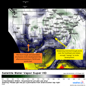
Here’s what we’re looking at for today: A more notable mid level trough and shortwaves associated with it will swing out of the four corners region during the day today and incite development in TX and OK and then points east this evening and overnight. Elsewhere, a weakening mid level trough exiting through the Ohio Valley will retain enough potency to incite development in the already-unstable air in place over the southeast.
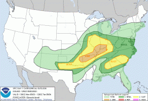
Here’s a look at the Day 1 Outlook from the SPC. I’m sharing it because a large portion of the country has potential to see severe weather today. If you reside under ANY of the colors displayed on the map, you need to know that you have some level of risk today and need to be aware. Damaging, devastating storms can, and often do, happen outside of the higher risk areas and all hazards are possible today, including tornadoes.
Texas through the Ohio Valley
This is actually a very complicated forecast due to several rounds of convection firing at different locations/different times in response to separate shortwaves and therefore having different hazards. I’ll be honest here, the complexity is confounding me a bit (remember, I’m still a student!), but I’ll do my best to outline the important points nonetheless.
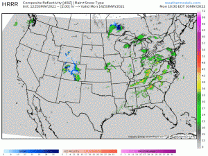
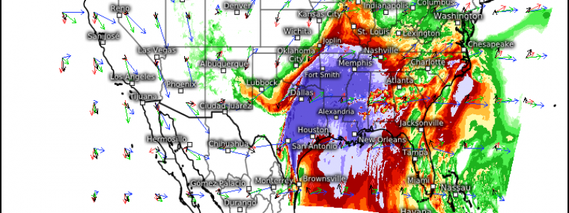
Perhaps the best way to discuss what we expect is to take a look at the HRRR 12z simulated radar since it mirrors the current thinking.
Let’s start with the more northern component: Iowa/Missouri into Illinois. As mentioned in the beginning of this post, dew points are already in/creeping into the 60s here. Surface analysis shows a rather broad area of low pressure approaching that will provide the lift to get storms going in this area. The extent to which this area of low pressure can advect in additional moisture and the amount of day time heating received will determine the hazards seen from these storms. At the very least, damaging winds and hail are possible. There is a somewhat conditional tornado threat, hinging on further destabilization, but for now, that threat remains low. An adjustment to that line of thinking may be needed should conditions become more conducive. Expect convective initiation shortly. Storms will likely be widely scattered at first but may experience upscale growth into a line once they move into more unstable air this afternoon.
Next, we look at Eastern Oklahoma into Western Tennessee/Kentucky. This is where we have the highest confidence in more significant severe weather though the SPC notes that the most uncertainty also exists here. That’s a bit confusing. Let’s leave it at this: This corridor has the most potential to produce in the biggest way today, but mesoscale uncertainties exist.
With the approach of a cold front later this afternoon/evening, initiation will be seen in Eastern Oklahoma. Storms may be widely scattered at first before forming into clusters of cells, or even supercells. In the early stages, we will see the most significant threat. Large to very large hail is possible thanks to steep lapse rates. Adequate shear could support the formation of tornadoes in the more discrete (separate) cells. As these storms progress northeastward, they will likely transition to more of a convective line with the main hazard becoming the wind. Fairly significant winds could be seen inside this line, even up to hurricane force.
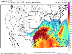
Lastly, we look at the southern high plains of Texas into the Red River region. Storms may form here behind the cold front this evening. Models suggest enough CAPE will remain behind the front (see graphic below) to allow for the possibility of the formation of a few supercells bearing large hail. Should these cells survive long enough to cross into more conducive conditions, they could re-strengthen and pose a renewed threat to Oklahoma eastward as a sort of second round.
The Southeast
The southeast will retain a risk for severe weather today thanks to a departing trough and very moist air already in place. Widespread cloud cover will hamper day time heating and the addition of further instability,
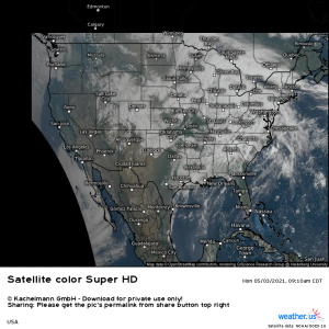
however, pockets of thin or broken cloud cover – as seen scattered on the satellite view – could lead to mesoscale destabilization and small areas with better conditions for severe weather. As noted by the slight risk area defined across AL/GA/SC, better instability thanks to more broken cloud cover and richer moisture may exist here. In fact, as I write this (10:25 am), a tornado warning has been issued for southern Atlanta.
Storm mode here is expected to remain messy. Clusters of cells, convective lines, and discrete supercells are all possible. With adequate shear in the range of 30 to 40 kts, tornadoes are possible, especially now, when surface winds are backed a bit to the SSE, giving that extra boost to rotation. Damaging winds and perhaps some small hail is also possible.
As far as timing goes, from now til this evening is the time to be alert. Activity is expected to diminish with the loss of day time heating and as the energy exits into the Atlantic.
That was a really long blog, so thanks for sticking with me if you’ve made it this far. To summarize: a large portion of the country has a severe threat today. The more significant threat exists from roughly Oklahoma through the Ohio Valley, however, the threat in the southeast should not be ignored as it has already produced a few tornado warnings this morning.
EVERYONE under any color in the Day 1 SPC outlook should be prepared for severe weather today. Have multiple ways to receive warnings. Have a plan in place and be able to execute it quickly. Monitor your local news stations for any updates or changes to the situation as it evolves. Your local meteorologists have you today. Trust them to keep you informed.
Stay safe!
