Looking Ahead at a Week of Impactful Weather
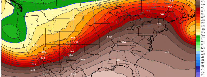
A flip flop in the pattern that we experienced over the weekend is occurring on this Monday. An area of high pressure that held up the ridge for the western states is wandering east and building a ridge over the eastern states. What goes up must come down somewhere, though, and a trough is beginning to dig deep in the west. This brings not only temperature changes, but also sensible weather changes, some of which could be significant.
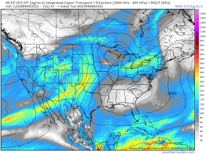
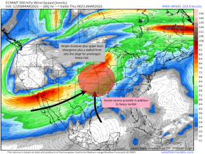
As the aforementioned high slides east and eventually sets up off the southeast coast, a strong ridge builds in. The high will funnel warm air into the eastern states but the southerly flow returns with the warm air as well, bringing in moisture and rising humidity levels. Meanwhile, a trough digs in over the western half and brings with it an upper level low that will progress east and then stall/move very slowly as it comes up against the eastern ridge. This stalled out/slow-moving low is then primed to cause all sorts of problems for the western half of the country.
Instead of going into detail on any one part of the impacts of this pattern, I’m going to give a bit of an overview since it is only Monday and most of these forecasted events occur later in the week. Jacob and I will refine the details and focus on specifics as we move into the short-range forecast period for each.
The Western Third
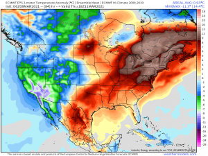
The western third of the country will be fully in the trough as it digs in. This, of course, means cooler air and below average temperatures are likely. But they will also be contending with a sluggish upper level low.
This low will have access to Pacific moisture as it comes ashore and will draw on it. Ample moisture aided by upper level divergence (lift) is a set up for heavy precipitation. This heavy precip will mainly come in the form of mountain snow both in the Sierra Nevadas and the Rockies of Colorado. The potential exists for significant accumulations so this will be an event to watch closely.
The Middle Third
This area of the country stands to see the most significant impacts from this set up. It is here the front will likely stall, allowing for prolonged precipitation leading to flooding issues. The risk of severe storms also looms on the horizons as conditions look to be conducive to at least a low-end event, if not more.
(gif) Link
At the onset, the system will be able to draw moisture from both the Pacific and the Gulf, funneling it into the Plains states. As the low moves (oh-so-slowly) east and deepens, it stops drawing from the Pacific but is able to ramp up the southerly flow from the Gulf, allowing for deep moisture to remain in place.
So with ample moisture, upper level divergence assisting in supplying lift, and a stalled front, the possibility exists for prolonged periods of heavy rainfall. Flash flooding is the most immediate concern, but river flooding could become a concern if the rain continues long enough. This pattern looks to persist through the weekend for now and some of the mid-range forecasts are showing some very heavy rainfall totals.
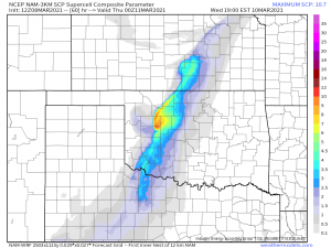
If all this talk about warm air, moisture, and lift is setting off some severe-related alarm bells in your head, you’d be right. We have a single-day severe risk for this area on Wednesday followed by a multi-day severe risk for the weekend. It’s a little early to discuss the weekend threat, but we can take a first glance at Wednesday’s set up.
Currently, far northern Oklahoma, Kansas, and Western Missouri are in a defined marginal risk. Though the set up doesn’t exactly scream “slam dunk” at the moment, it shows enough promise to warrant monitoring. Adequate shear of 50 to 60 kts will exist near the frontal boundary, lapse rates are expected to be decent- in the neighborhood of 7 to 8 degrees C per km, CAPE, though initially on the low end, is expected to rise to ~1500 J/kg as the evening progresses, and dewpoints are expected to rise into the mid-to-upper 50s.
Not a particularly exciting set of parameters, but still more than capable of producing severe weather in some form, likely damaging winds or a few tornadoes. Right now, this looks to be an evening and overnight event, so closely monitor it’s evolution and prepare accordingly. Don’t get caught off guard in the middle of the night. We’ll revisit these threats in the coming days as the forecast solidifies.
The Eastern Third
This part of the country will experience the most pleasant weather by far offered during the duration of this pattern.
Temperature anomalies soar to nearly 20 degrees above average over the northeast while the south also experiences warmer-than-average spring temperatures.
Being under this ridge doesn’t just mean it will be warm, though. It will also be rather dry. High pressure will force any rainfall up and away from the east coast, at least until the weekend. The dry weather is great news for those who want to get out and enjoy the warmth, but it comes with an often-overlooked side effect: drought. Parts of the deep south and northeast are in moderate drought. This period of dry, warm weather will only exacerbate that. There isn’t very much in the way of rainfall on the horizon for these areas in the medium range either, which means drought may worsen. Relative humidity will be increasing as the week progresses but nonetheless, use caution in your outdoor activities in regards to burning, whether it be burning trash or enjoying a bonfire.
So, that’s what we’re expecting to occur as we move through the week. The forecast can and probably will change some as the week progresses and we will keep you informed of said changes here in the blog and on Twitter. Look for more specific analyses in the coming days!

